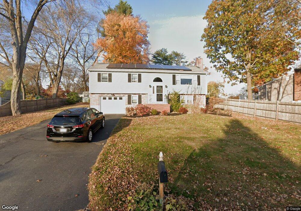
61 Longfellow Dr Newburyport, MA 01950
Estimated Value: $813,526 - $910,000
4
Beds
2
Baths
1,332
Sq Ft
$654/Sq Ft
Est. Value
About This Home
This home is located at 61 Longfellow Dr, Newburyport, MA 01950 and is currently estimated at $871,382, approximately $654 per square foot. 61 Longfellow Dr is a home located in Essex County with nearby schools including Francis T. Bresnahan Elementary School, Edward G. Molin Elementary School, and Rupert A. Nock Middle School.
Ownership History
Date
Name
Owned For
Owner Type
Purchase Details
Closed on
May 23, 2024
Sold by
Sachs Carol
Bought by
Carol Ann Sachs Ret and Sachs-Guthrie
Current Estimated Value
Purchase Details
Closed on
Mar 29, 2012
Sold by
Sachs Brian D and Sachs Carol
Bought by
Sachs Carol
Purchase Details
Closed on
May 29, 1998
Sold by
Decrescenzo Donna M
Bought by
Sachs Brian D and Sachs Carol
Create a Home Valuation Report for This Property
The Home Valuation Report is an in-depth analysis detailing your home's value as well as a comparison with similar homes in the area
Home Values in the Area
Average Home Value in this Area
Purchase History
| Date | Buyer | Sale Price | Title Company |
|---|---|---|---|
| Carol Ann Sachs Ret | -- | None Available | |
| Carol Ann Sachs Ret | -- | None Available | |
| Sachs Carol | -- | -- | |
| Sachs Brian D | $194,000 | -- | |
| Sachs Carol | -- | -- | |
| Sachs Brian D | $194,000 | -- |
Source: Public Records
Mortgage History
| Date | Status | Borrower | Loan Amount |
|---|---|---|---|
| Previous Owner | Sachs Brian D | $212,000 | |
| Previous Owner | Sachs Brian D | $215,000 |
Source: Public Records
Tax History Compared to Growth
Tax History
| Year | Tax Paid | Tax Assessment Tax Assessment Total Assessment is a certain percentage of the fair market value that is determined by local assessors to be the total taxable value of land and additions on the property. | Land | Improvement |
|---|---|---|---|---|
| 2025 | $7,021 | $732,900 | $397,800 | $335,100 |
| 2024 | $6,985 | $700,600 | $361,600 | $339,000 |
| 2023 | $6,620 | $616,400 | $314,400 | $302,000 |
| 2022 | $6,161 | $513,000 | $262,000 | $251,000 |
| 2021 | $5,539 | $438,200 | $238,200 | $200,000 |
| 2020 | $5,626 | $438,200 | $238,200 | $200,000 |
| 2019 | $5,732 | $438,200 | $238,200 | $200,000 |
| 2018 | $5,597 | $422,100 | $226,900 | $195,200 |
| 2017 | $5,411 | $402,300 | $216,100 | $186,200 |
| 2016 | $5,118 | $382,200 | $205,800 | $176,400 |
| 2015 | $4,692 | $351,700 | $205,800 | $145,900 |
Source: Public Records
Map
Nearby Homes
- 16 Newhall Ln
- 100 Turkey Hill Rd
- 17 Lavalley Ln
- 7 Peters Rd
- 237 Storey Ave
- 231 Storey Ave
- 6 Doe Run Dr
- 10 Clipper Way
- 6 Woodman Way Unit 402
- 6 Woodman Way Unit 121
- 169 Scotland Rd
- 13 Turkey Hill Rd
- 2 Hunter Dr
- 42 Myrtle Ave
- 138 Low St
- 6 Boyd Dr
- 8 Brown Ave
- 43 Ferry Rd
- 29 Columbus Ave
- 12 Roosevelt Place
- 59 Longfellow Dr
- 63 Longfellow Dr
- 18 Elizabeth Ln
- 7 Marquand Ln
- 57 Longfellow Dr
- 70 Longfellow Dr
- 9 Marquand Ln
- 72 Longfellow Dr
- 68 Longfellow Dr
- 74 Longfellow Dr
- 19 Elizabeth Ln
- 16 Elizabeth Ln
- 66 Longfellow Dr
- 65 Longfellow Dr
- 8 Marquand Ln
- 55 Longfellow Dr
- 11 Marquand Ln
- 76 Longfellow Dr
- 17 Elizabeth Ln
- 64 Longfellow Dr