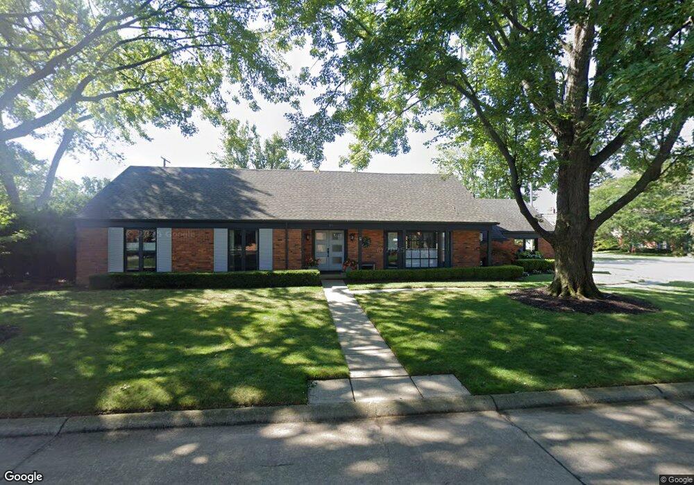
61 N Duval Rd Unit Bldg-Unit Grosse Pointe Shores, MI 48236
Estimated Value: $582,000 - $728,000
--
Bed
4
Baths
2,797
Sq Ft
$236/Sq Ft
Est. Value
About This Home
This home is located at 61 N Duval Rd Unit Bldg-Unit, Grosse Pointe Shores, MI 48236 and is currently estimated at $660,398, approximately $236 per square foot. 61 N Duval Rd Unit Bldg-Unit is a home located in Wayne County with nearby schools including Ferry Elementary School, Parcells Middle School, and Grosse Pointe North High School.
Ownership History
Date
Name
Owned For
Owner Type
Purchase Details
Closed on
May 6, 2020
Sold by
Melynk Charles S
Bought by
Flanagan Sarah and Philbin S Flanagan Living Trust
Current Estimated Value
Purchase Details
Closed on
May 25, 2017
Sold by
Rsl Group Llc
Bought by
Melnyk Charles S
Purchase Details
Closed on
Aug 19, 2016
Sold by
Roach Kenneth R and Heaton Heleen
Bought by
Rsl Group Llc
Create a Home Valuation Report for This Property
The Home Valuation Report is an in-depth analysis detailing your home's value as well as a comparison with similar homes in the area
Home Values in the Area
Average Home Value in this Area
Purchase History
| Date | Buyer | Sale Price | Title Company |
|---|---|---|---|
| Flanagan Sarah | $575,000 | Premier Title Agency Llc | |
| Melnyk Charles S | $525,000 | First American Title | |
| Rsl Group Llc | $360,000 | Greco Title Agency Llc |
Source: Public Records
Tax History Compared to Growth
Tax History
| Year | Tax Paid | Tax Assessment Tax Assessment Total Assessment is a certain percentage of the fair market value that is determined by local assessors to be the total taxable value of land and additions on the property. | Land | Improvement |
|---|---|---|---|---|
| 2025 | $13,343 | $305,600 | $0 | $0 |
| 2024 | $13,343 | $294,800 | $0 | $0 |
| 2023 | $13,343 | $259,800 | $0 | $0 |
| 2022 | $13,343 | $251,700 | $0 | $0 |
| 2021 | $13,343 | $259,700 | $0 | $0 |
| 2019 | $12,402 | $236,000 | $0 | $0 |
| 2018 | $7,880 | $224,100 | $0 | $0 |
| 2017 | $8,049 | $218,200 | $0 | $0 |
| 2016 | $10,419 | $209,200 | $0 | $0 |
| 2015 | $18,952 | $197,100 | $0 | $0 |
| 2013 | $18,360 | $183,610 | $0 | $0 |
| 2011 | -- | $208,650 | $0 | $0 |
Source: Public Records
Map
Nearby Homes
- 21560 van K Dr
- 34 Putnam Place
- 700 Woods Ln
- 580 N Brys Dr
- 22925 Gary Ln Unit 77
- 22852 Allen Ct Unit 150
- 23118 Westbury St
- 935 S Brys Dr
- 23280 Clairwood St
- 23112 Marter Rd
- 23162 Doremus St
- 22997 Carolina St
- 65 Vernier Rd
- 1039 Hawthorne Rd
- 22948 Lingemann St
- 1158 Hawthorne Rd
- 1291 Roslyn Rd
- 20670 Vernier Cir
- 926 Lochmoor Place
- 1381 Brys Dr