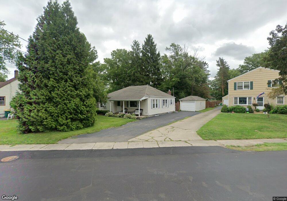
61 Newton Rd Hamburg, NY 14075
Estimated Value: $194,000 - $259,223
2
Beds
1
Bath
1,029
Sq Ft
$220/Sq Ft
Est. Value
About This Home
This home is located at 61 Newton Rd, Hamburg, NY 14075 and is currently estimated at $226,806, approximately $220 per square foot. 61 Newton Rd is a home located in Erie County with nearby schools including Hamburg Middle School, Sts. Peter & Paul Elementary School, and Hamburg Christian Academy.
Ownership History
Date
Name
Owned For
Owner Type
Purchase Details
Closed on
Sep 5, 2007
Sold by
Donahue Martin F and Donahue Marybeth C
Bought by
Deutsche Bank National Trust Co and Abfc 2004-He1 Trust Abfc Asset Backed Ce
Current Estimated Value
Purchase Details
Closed on
Jul 28, 2006
Sold by
Check Donahue Mary Beth
Bought by
Donahue Martin F
Purchase Details
Closed on
Apr 26, 2004
Sold by
Donahue Martin F
Bought by
Donahue Martin F and Donahue Marybeth C
Home Financials for this Owner
Home Financials are based on the most recent Mortgage that was taken out on this home.
Original Mortgage
$94,500
Interest Rate
5.36%
Mortgage Type
Purchase Money Mortgage
Purchase Details
Closed on
Apr 17, 1995
Sold by
Steen Douglas M Steen Robin M
Bought by
Donahue Martin F
Create a Home Valuation Report for This Property
The Home Valuation Report is an in-depth analysis detailing your home's value as well as a comparison with similar homes in the area
Home Values in the Area
Average Home Value in this Area
Purchase History
| Date | Buyer | Sale Price | Title Company |
|---|---|---|---|
| Deutsche Bank National Trust Co | $107,060 | None Available | |
| Donahue Martin F | -- | None Available | |
| Donahue Martin F | -- | -- | |
| Donahue Martin F | $75,000 | -- |
Source: Public Records
Mortgage History
| Date | Status | Borrower | Loan Amount |
|---|---|---|---|
| Previous Owner | Donahue Martin F | $94,500 |
Source: Public Records
Tax History Compared to Growth
Tax History
| Year | Tax Paid | Tax Assessment Tax Assessment Total Assessment is a certain percentage of the fair market value that is determined by local assessors to be the total taxable value of land and additions on the property. | Land | Improvement |
|---|---|---|---|---|
| 2024 | $5,749 | $63,000 | $8,500 | $54,500 |
| 2023 | $5,631 | $63,000 | $8,500 | $54,500 |
| 2022 | $5,360 | $63,000 | $8,500 | $54,500 |
| 2021 | $3,980 | $63,000 | $8,500 | $54,500 |
| 2020 | $4,615 | $63,000 | $8,500 | $54,500 |
| 2019 | $4,298 | $63,000 | $8,500 | $54,500 |
| 2018 | $4,451 | $63,000 | $8,500 | $54,500 |
| 2017 | $1,317 | $63,000 | $8,500 | $54,500 |
| 2016 | $4,329 | $63,000 | $8,500 | $54,500 |
| 2015 | -- | $63,000 | $8,500 | $54,500 |
| 2014 | -- | $63,000 | $8,500 | $54,500 |
Source: Public Records
Map
Nearby Homes
- 27 Huntington Ct
- 6309 Boston State Rd
- 11 Hunt Ave
- 88 Raymond St
- 82 Raymond St
- 25 Brendel Ave
- 187 Hunt Ave
- 42 Sandra Place
- 6145 Mckinley Pkwy Unit 31
- 6145 Mckinley Pkwy Unit 5
- 21 Dudley Ave
- 4700 Newton Rd
- 5985 Mckinley Pkwy
- 87 Maple Ave
- 38 Oliver Place
- 43 Oliver Place
- 30 Woodview Ct
- 24 Viber Unit 275
- 5962 Rosewood W
- 9 Viber Unit 263