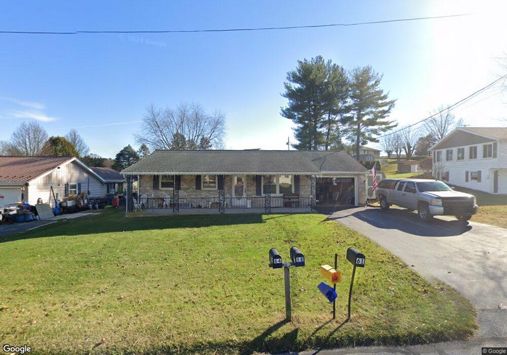
61 Peanut Dr Hanover, PA 17331
Estimated Value: $241,000 - $304,702
3
Beds
2
Baths
1,215
Sq Ft
$212/Sq Ft
Est. Value
About This Home
This home is located at 61 Peanut Dr, Hanover, PA 17331 and is currently estimated at $258,176, approximately $212 per square foot. 61 Peanut Dr is a home located in Adams County with nearby schools including New Oxford Senior High School, St. Teresa of Calcutta Catholic School - Conewago Campus, and St. Teresa of Calcutta Catholic School - McSherrystown Campus.
Ownership History
Date
Name
Owned For
Owner Type
Purchase Details
Closed on
Nov 8, 2011
Sold by
Mcwilliams Pamela D and Mcwilliams Lenny
Bought by
Pittinger Charisse M
Current Estimated Value
Home Financials for this Owner
Home Financials are based on the most recent Mortgage that was taken out on this home.
Original Mortgage
$97,000
Outstanding Balance
$66,113
Interest Rate
4.01%
Mortgage Type
Purchase Money Mortgage
Estimated Equity
$192,063
Create a Home Valuation Report for This Property
The Home Valuation Report is an in-depth analysis detailing your home's value as well as a comparison with similar homes in the area
Home Values in the Area
Average Home Value in this Area
Purchase History
| Date | Buyer | Sale Price | Title Company |
|---|---|---|---|
| Pittinger Charisse M | $75,000 | None Available |
Source: Public Records
Mortgage History
| Date | Status | Borrower | Loan Amount |
|---|---|---|---|
| Open | Pittinger Charisse M | $97,000 |
Source: Public Records
Tax History
| Year | Tax Paid | Tax Assessment Tax Assessment Total Assessment is a certain percentage of the fair market value that is determined by local assessors to be the total taxable value of land and additions on the property. | Land | Improvement |
|---|---|---|---|---|
| 2025 | $4,049 | $169,100 | $36,200 | $132,900 |
| 2024 | $3,740 | $169,100 | $36,200 | $132,900 |
| 2023 | $3,602 | $169,100 | $36,200 | $132,900 |
| 2022 | $3,492 | $169,100 | $36,200 | $132,900 |
| 2021 | $3,402 | $169,100 | $36,200 | $132,900 |
| 2020 | $3,407 | $169,100 | $36,200 | $132,900 |
| 2019 | $3,254 | $169,100 | $36,200 | $132,900 |
| 2018 | $3,186 | $169,100 | $36,200 | $132,900 |
| 2017 | $3,055 | $169,100 | $36,200 | $132,900 |
| 2016 | -- | $169,100 | $36,200 | $132,900 |
| 2015 | -- | $169,100 | $36,200 | $132,900 |
| 2014 | -- | $169,100 | $36,200 | $132,900 |
Source: Public Records
Map
Nearby Homes
- 177 Skyview Cir
- 136 Conewago Dr Unit 14
- 426 N 3rd St Unit 53
- 209 N 3rd St
- 235 Ridge Ave
- 507 Ridge Ave Unit 48
- 86 Barley Cir Unit 9
- 23 Westview Dr Unit 6
- 504 North St
- 128 North St
- 0 Red Hill Mt Misery Roads
- 618 North St
- 527 Main St
- 5955 Hanover Rd
- 11 Flint Dr
- 2779 Centennial Rd
- 65 Flint Dr
- 46 Flint Dr
- 70 Flint Dr Unit 48
- 124 Flint Dr Unit 61
- 71 Peanut Dr Unit 479
- 53 Peanut Dr Unit 28
- 75 Peanut Dr Unit 31
- 10 Locust Dr
- 20 Locust Dr Unit 43
- 22 Locust Dr Unit 42
- 64 Peanut Dr
- 56 Peanut Dr
- 79 Peanut Dr Unit 32
- 47 Peanut Dr
- 76 Peanut Dr
- 30 Locust Dr Unit 41
- 50 Peanut Dr
- 17 Evergreen Dr Unit 35
- 50 Oak Dr
- 50 Oak Dr Unit 18
- 41 Peanut Dr
- 5 Locust Dr
- 25 Evergreen Dr Unit 36
- 80 Peanut Dr Unit 2
Your Personal Tour Guide
Ask me questions while you tour the home.