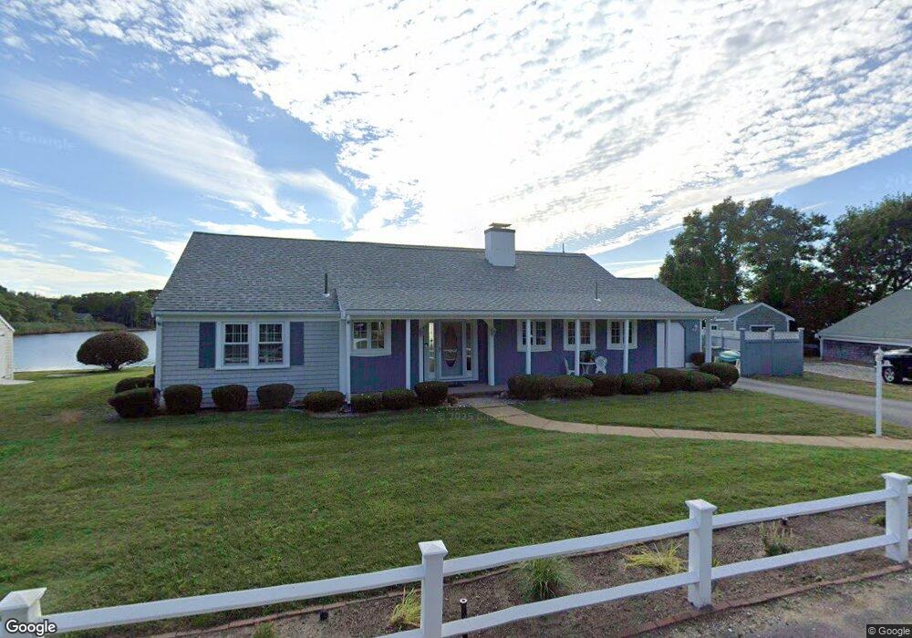
61 Stafford Cir Dennis Port, MA 02639
Dennis Port NeighborhoodEstimated Value: $1,024,000 - $1,257,375
4
Beds
3
Baths
2,549
Sq Ft
$440/Sq Ft
Est. Value
About This Home
This home is located at 61 Stafford Cir, Dennis Port, MA 02639 and is currently estimated at $1,122,594, approximately $440 per square foot. 61 Stafford Cir is a home located in Barnstable County with nearby schools including Dennis-Yarmouth Regional High School and St. Pius X. School.
Ownership History
Date
Name
Owned For
Owner Type
Purchase Details
Closed on
Jun 4, 2014
Sold by
Rogers William J and Rogers Dorothy D
Bought by
Rogers Ft
Current Estimated Value
Purchase Details
Closed on
Jun 11, 2010
Sold by
Rogers William J
Bought by
Rogers William J and Rogers Dorothy D
Create a Home Valuation Report for This Property
The Home Valuation Report is an in-depth analysis detailing your home's value as well as a comparison with similar homes in the area
Home Values in the Area
Average Home Value in this Area
Purchase History
| Date | Buyer | Sale Price | Title Company |
|---|---|---|---|
| Rogers Ft | -- | -- | |
| Rogers William J | -- | -- |
Source: Public Records
Tax History Compared to Growth
Tax History
| Year | Tax Paid | Tax Assessment Tax Assessment Total Assessment is a certain percentage of the fair market value that is determined by local assessors to be the total taxable value of land and additions on the property. | Land | Improvement |
|---|---|---|---|---|
| 2025 | $4,702 | $1,086,000 | $329,400 | $756,600 |
| 2024 | $4,605 | $1,049,000 | $316,700 | $732,300 |
| 2023 | $4,437 | $950,000 | $287,900 | $662,100 |
| 2022 | $4,184 | $747,200 | $259,400 | $487,800 |
| 2021 | $4,077 | $676,200 | $254,300 | $421,900 |
| 2020 | $3,978 | $652,100 | $254,300 | $397,800 |
| 2019 | $628 | $603,800 | $249,300 | $354,500 |
| 2018 | $2,977 | $532,300 | $197,800 | $334,500 |
| 2017 | $3,274 | $532,300 | $197,800 | $334,500 |
| 2016 | $3,200 | $490,100 | $214,700 | $275,400 |
| 2015 | $3,137 | $490,100 | $214,700 | $275,400 |
| 2014 | $3,047 | $479,800 | $214,700 | $265,100 |
Source: Public Records
Map
Nearby Homes
- 11 Lane Rd
- 24 Indian Trail
- 78 Upper County Rd Unit A&B
- 78 Upper County Rd
- 9 Country Ln
- 91 Depot Rd W
- 47 Telegraph Rd Unit 1
- 12 Candlewood Ln Unit 2-9
- 10 Candlewood Ln Unit 2-1
- 141 Division St
- 141 Division St
- 20 Aunt Debbys Rd
- 537 Depot St
- 171 Searsville Rd
- 360 Center St
- 268 Main St
- 45 Route 28
- 116 Searsville Rd
- 9 Bells Neck Rd Unit 10
- 72 Bassett Ln
- 55 Stafford Cir
- 65 Stafford Cir
- 52 Stafford Cir
- 69 Stafford Cir
- 51 Stafford Cir
- 46 Stafford Cir
- 62 Stafford Cir
- 75 Stafford Cir
- 45 Stafford Cir
- 0 Stafford Cir
- 42 Stafford Cir
- 31 Knox Rd
- 38 Stafford Cir
- 66 Stafford Cir
- 23 Knox Rd
- 39 Stafford Cir
- 17 Knox Rd
- 83 Stafford Cir
- 34 Stafford Cir
- 35 Stafford Cir