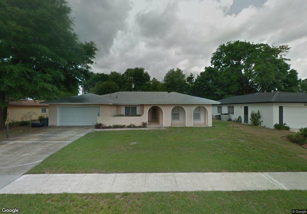
610 Brookside Rd Maitland, FL 32751
Estimated Value: $520,000 - $584,000
4
Beds
2
Baths
2,233
Sq Ft
$246/Sq Ft
Est. Value
About This Home
This home is located at 610 Brookside Rd, Maitland, FL 32751 and is currently estimated at $548,302, approximately $245 per square foot. 610 Brookside Rd is a home located in Seminole County with nearby schools including English Estates Elementary School, South Seminole Academy, and Lake Howell High School.
Ownership History
Date
Name
Owned For
Owner Type
Purchase Details
Closed on
Jan 31, 2025
Sold by
Mcmiller Patricia Leita and Norris Laneer
Bought by
610 Brookside Land Trust and Trste Llc
Current Estimated Value
Purchase Details
Closed on
Dec 13, 2016
Sold by
Leita Patricia L and Mcmiller Norris Laneer
Bought by
Mcmiller Norris Laneer and Mcmiller Patricia Leita
Purchase Details
Closed on
Sep 6, 2006
Sold by
Leita Richard and Leita Patricia
Bought by
Leita Patricia
Purchase Details
Closed on
Dec 1, 1987
Bought by
Leita Patricia L
Create a Home Valuation Report for This Property
The Home Valuation Report is an in-depth analysis detailing your home's value as well as a comparison with similar homes in the area
Home Values in the Area
Average Home Value in this Area
Purchase History
| Date | Buyer | Sale Price | Title Company |
|---|---|---|---|
| 610 Brookside Land Trust | $250,000 | Cobblestone Title Services | |
| 610 Brookside Land Trust | $250,000 | Cobblestone Title Services | |
| Mcmiller Norris Laneer | -- | Attorney | |
| Leita Patricia | -- | None Available | |
| Leita Patricia L | $78,000 | -- |
Source: Public Records
Tax History Compared to Growth
Tax History
| Year | Tax Paid | Tax Assessment Tax Assessment Total Assessment is a certain percentage of the fair market value that is determined by local assessors to be the total taxable value of land and additions on the property. | Land | Improvement |
|---|---|---|---|---|
| 2024 | $340 | $186,160 | -- | -- |
| 2023 | $340 | $180,738 | $0 | $0 |
| 2021 | $275 | $170,363 | $0 | $0 |
| 2020 | $270 | $168,011 | $0 | $0 |
| 2019 | $270 | $164,234 | $0 | $0 |
| 2018 | $257 | $161,172 | $0 | $0 |
| 2017 | $252 | $157,857 | $0 | $0 |
| 2016 | $2,030 | $155,692 | $0 | $0 |
| 2015 | $1,786 | $153,535 | $0 | $0 |
| 2014 | $1,786 | $152,316 | $0 | $0 |
Source: Public Records
Map
Nearby Homes
- 572 Green Meadow Ct
- 671 Brookside Rd
- 708 Thunder Trail
- 2514 Tuscarora Trail
- 702 Green Meadow Ave
- 2338 Tuscarora Trail
- 2634 Ultra Vista Dr
- 0 Lake Howell Rd Unit MFRO6346556
- 736 Forest Glen Ct
- 1990 Kenaston Rd Unit 1990
- 2162 Lake Howell Preserve Ct
- 778 Lake Howell Rd
- 2344 Sierra Ln
- 2955 Lolissa Ln
- 2491 Lauder Dr
- 1024 Kewannee Trail
- 1135 Thunder Trail
- 2666 Derbyshire Rd
- 2400 Deloraine Trail
- 2632 Derbyshire Rd
- 620 Brookside Rd
- 600 Brookside Rd
- 2617 Tuscarora Trail
- 630 Brookside Rd
- 611 Brookside Rd
- 2639 Tuscarora Trail
- 621 Brookside Rd
- 2611 Tuscarora Trail
- 607 Thunder Trail
- 640 Brookside Rd
- 631 Brookside Rd
- 2605 Tuscarora Trail
- 590 Brookside Cir
- 615 Thunder Trail
- 2645 Tuscarora Trail
- 2630 Tuscarora Trail
- 612 Green Meadow Ave
- 622 Green Meadow Ave
- 641 Brookside Rd
- 591 Brookside Cir