Estimated Value: $93,374 - $249,000
--
Bed
1
Bath
932
Sq Ft
$164/Sq Ft
Est. Value
About This Home
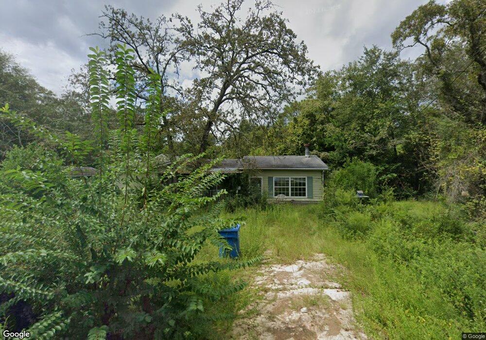
This home is located at 610 Community Cir, Jesup, GA 31545 and is currently estimated at $152,594, approximately $163 per square foot. 610 Community Cir is a home located in Wayne County with nearby schools including Martha Rawls Smith Elementary School, Arthur Williams Middle School, and Wayne County High School.
Ownership History
Date
Name
Owned For
Owner Type
Purchase Details
Closed on
Dec 7, 2022
Sold by
Landon Barbara Jean
Bought by
Lamb Kenyon Vance
Current Estimated Value
Purchase Details
Closed on
Jul 1, 2016
Sold by
Surrency Norma Stewart
Bought by
Smith Jakey Lamar
Purchase Details
Closed on
Jan 21, 2011
Sold by
Nordberg Minnie Jo
Bought by
Landon Barbara
Purchase Details
Closed on
Apr 1, 2002
Sold by
Hoagland Dennis W and Hoagland Lorrie A
Bought by
Nordberg Minnie Jo Etal
Purchase Details
Closed on
Apr 1, 1993
Bought by
Hoagland Dennis W and Hoagland Lorrie A
Purchase Details
Closed on
May 1, 1992
Purchase Details
Closed on
Oct 1, 1988
Purchase Details
Closed on
May 1, 1987
Purchase Details
Closed on
Sep 1, 1976
Purchase Details
Closed on
Jul 1, 1976
Purchase Details
Closed on
Nov 1, 1963
Create a Home Valuation Report for This Property
The Home Valuation Report is an in-depth analysis detailing your home's value as well as a comparison with similar homes in the area
Home Values in the Area
Average Home Value in this Area
Purchase History
| Date | Buyer | Sale Price | Title Company |
|---|---|---|---|
| Lamb Kenyon Vance | $50,000 | -- | |
| Smith Jakey Lamar | $5,500 | -- | |
| Landon Barbara | -- | -- | |
| Nordberg Minnie Jo Etal | $22,400 | -- | |
| Hoagland Dennis W | $22,000 | -- | |
| -- | $18,000 | -- | |
| -- | $19,900 | -- | |
| -- | $21,600 | -- | |
| -- | -- | -- | |
| -- | -- | -- | |
| -- | -- | -- |
Source: Public Records
Tax History Compared to Growth
Tax History
| Year | Tax Paid | Tax Assessment Tax Assessment Total Assessment is a certain percentage of the fair market value that is determined by local assessors to be the total taxable value of land and additions on the property. | Land | Improvement |
|---|---|---|---|---|
| 2024 | $507 | $19,154 | $1,600 | $17,554 |
| 2023 | $129 | $14,064 | $1,600 | $12,464 |
| 2022 | $443 | $14,064 | $1,600 | $12,464 |
| 2021 | $474 | $14,064 | $1,600 | $12,464 |
| 2020 | $507 | $14,534 | $2,070 | $12,464 |
| 2019 | $522 | $14,534 | $2,070 | $12,464 |
| 2018 | $522 | $14,534 | $2,070 | $12,464 |
| 2017 | $449 | $14,534 | $2,070 | $12,464 |
| 2016 | $435 | $14,534 | $2,070 | $12,464 |
| 2014 | $436 | $14,534 | $2,070 | $12,464 |
| 2013 | -- | $14,534 | $2,070 | $12,464 |
Source: Public Records
Map
Nearby Homes
- 186 Community Cir
- 200 W Melody Dr
- 125 Pleasant Way
- 131 Mill Creek Ln
- 143 Caleb Cir
- 260 Pine Ridge Rd
- 290 Yellow Pine Rd
- 95 Mayflower Rd
- 196 Pine Ridge Rd
- Lot 1,2,3 Rayonier Rd
- 556 Caleb Cir
- 1275 Rayonier Rd
- 47 Yellow Pine Rd
- 75 Woodlawn Dr
- 141 Nichols Rd
- 1276 Spring Grove Rd
- 2636 Beechwood Dr
- 1 Palm Island Cir
- 0 Palm Island Cir
- 560 Community Cir
- 658 Community Cir
- 625 Community Cir
- 311 Oak Ridge Rd
- 655 Community Cir
- 226 Community Cir
- 530 Community Cir
- 66 Community Cir
- 511 Community Cir
- 203 Oak Ridge Rd
- 741 Community Cir
- 99 W Melody Dr
- 752 Community Cir
- 485 Community Cir
- 63 W Melody Dr
- 425 Community Cir
- 155 W Melody Dr
- LOT 130 Melody Dr
- 146 Community Cir
- 0 W Melody Dr Unit 143140