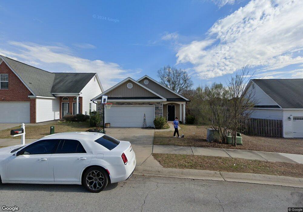
610 Dunrobin Ln Grovetown, GA 30813
Estimated Value: $239,904 - $252,000
3
Beds
2
Baths
1,480
Sq Ft
$165/Sq Ft
Est. Value
About This Home
This home is located at 610 Dunrobin Ln, Grovetown, GA 30813 and is currently estimated at $244,476, approximately $165 per square foot. 610 Dunrobin Ln is a home located in Columbia County with nearby schools including Baker Place Elementary School, Rockbridge Elementary School, and Gilmer Middle School.
Ownership History
Date
Name
Owned For
Owner Type
Purchase Details
Closed on
Mar 26, 2024
Sold by
Evans Barbara
Bought by
Evans Jason Duvall
Current Estimated Value
Purchase Details
Closed on
Aug 21, 2020
Sold by
Perry Timothy M
Bought by
Sigg James A
Purchase Details
Closed on
Jun 12, 2019
Sold by
Evans Calvin
Bought by
Evans Jason Duvall and Evans Barbara F
Home Financials for this Owner
Home Financials are based on the most recent Mortgage that was taken out on this home.
Original Mortgage
$156,120
Interest Rate
4.12%
Mortgage Type
FHA
Purchase Details
Closed on
Feb 10, 2009
Sold by
Jeff Mcnair Const Inc
Bought by
Evans Calvin
Home Financials for this Owner
Home Financials are based on the most recent Mortgage that was taken out on this home.
Original Mortgage
$145,716
Interest Rate
5.03%
Mortgage Type
VA
Create a Home Valuation Report for This Property
The Home Valuation Report is an in-depth analysis detailing your home's value as well as a comparison with similar homes in the area
Home Values in the Area
Average Home Value in this Area
Purchase History
| Date | Buyer | Sale Price | Title Company |
|---|---|---|---|
| Evans Jason Duvall | -- | -- | |
| Sigg James A | $159,200 | -- | |
| Evans Jason Duvall | $159,000 | -- | |
| Evans Calvin | $142,700 | -- |
Source: Public Records
Mortgage History
| Date | Status | Borrower | Loan Amount |
|---|---|---|---|
| Previous Owner | Evans Jason Duvall | $156,120 | |
| Previous Owner | Evans Calvin | $145,716 |
Source: Public Records
Tax History Compared to Growth
Tax History
| Year | Tax Paid | Tax Assessment Tax Assessment Total Assessment is a certain percentage of the fair market value that is determined by local assessors to be the total taxable value of land and additions on the property. | Land | Improvement |
|---|---|---|---|---|
| 2025 | $2,276 | $92,948 | $19,304 | $73,644 |
| 2024 | $2,352 | $91,787 | $20,804 | $70,983 |
| 2023 | $2,352 | $87,717 | $19,504 | $68,213 |
| 2022 | $2,113 | $79,071 | $17,304 | $61,767 |
| 2021 | $1,936 | $69,060 | $16,104 | $52,956 |
| 2020 | $1,825 | $63,600 | $14,404 | $49,196 |
| 2019 | $1,822 | $63,496 | $14,604 | $48,892 |
| 2018 | $1,729 | $59,960 | $14,104 | $45,856 |
| 2017 | $1,699 | $58,663 | $13,104 | $45,559 |
| 2016 | $1,584 | $56,585 | $12,280 | $44,305 |
| 2015 | $1,494 | $53,120 | $11,980 | $41,140 |
| 2014 | $1,423 | $49,879 | $11,080 | $38,799 |
Source: Public Records
Map
Nearby Homes
- 613 Dunrobin Ln
- 2051 Dundee Way
- 1803 Dunrobin Ct
- 3010 Kilknockie Dr
- 214 Kickham Ln
- 304 High Meadows Place
- 3027 Kilknockie Dr
- 520 Sweet Meadow Dr
- 932 Niagra Falls
- 727 Ronaldsay Rd
- 690 Ronaldsay Rd
- Montauk 2 Plan at Misty Meadows
- Haverford Plan at Misty Meadows
- Covington 7 Plan at Misty Meadows
- Kelly 9 Plan at Misty Meadows
- Riverton 3 Plan at Misty Meadows
- Oxford Plan at Misty Meadows
- Lyndhurst Plan at Misty Meadows
- Riverton 4 Plan at Misty Meadows
- Stoneridge Plan at Misty Meadows
- 612 Dunrobin Ln
- 2022 Dundee Way
- 614 Dunrobin Ln
- 2020 Dundee Way
- 604 Dunrobin Ln
- 616 Dunrobin Ln
- 627 Dunrobin Ln
- 2008 Dundee Way
- 2006 Dundee Way
- 607 Dunrobin Ln
- 2010 Dundee Way
- 611 Dunrobin Ln
- 605 Dunrobin Ln
- 618 Dunrobin Ln
- 609 Dunrobin Ln
- 2004 Dundee Way
- 620 Dunrobin Ln
- 615 Dunrobin Ln
- 2025 Dundee Way
- 2002 Dundee Way