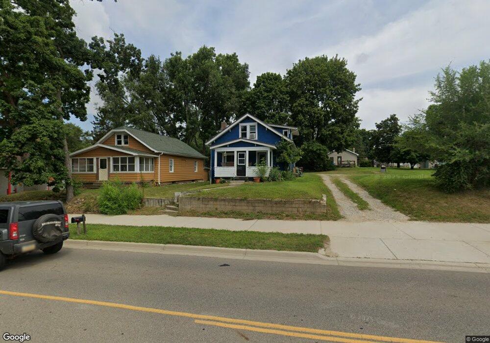
610 E Mcdevitt Ave Jackson, MI 49203
Estimated Value: $98,000 - $147,000
3
Beds
1
Bath
1,202
Sq Ft
$105/Sq Ft
Est. Value
About This Home
This home is located at 610 E Mcdevitt Ave, Jackson, MI 49203 and is currently estimated at $126,667, approximately $105 per square foot. 610 E Mcdevitt Ave is a home located in Jackson County with nearby schools including Townsend Elementary School, Vandercook Lake High School, and Jackson Preparatory & Early College.
Ownership History
Date
Name
Owned For
Owner Type
Purchase Details
Closed on
Mar 2, 2022
Sold by
Terry Ryan
Bought by
Saw Financial Llc
Current Estimated Value
Purchase Details
Closed on
Aug 5, 2021
Sold by
Foster Jennifer and Terry Jennifer
Bought by
Saw Financial Llc
Purchase Details
Closed on
Jul 18, 2017
Sold by
Terry Ryan K and Foster Jennifer L
Bought by
Terry Ryan K
Purchase Details
Closed on
Aug 23, 2013
Sold by
Gregory Pamela S and Clem Emily
Bought by
Terry Ryan K and Terry Jennifer L
Purchase Details
Closed on
Jan 14, 1998
Sold by
Clem Emily
Bought by
Clem Emily and Gregory Pamela S
Create a Home Valuation Report for This Property
The Home Valuation Report is an in-depth analysis detailing your home's value as well as a comparison with similar homes in the area
Home Values in the Area
Average Home Value in this Area
Purchase History
| Date | Buyer | Sale Price | Title Company |
|---|---|---|---|
| Saw Financial Llc | $78,636 | -- | |
| Saw Financial Llc | -- | None Available | |
| Terry Ryan K | -- | None Available | |
| Terry Ryan K | $20,000 | At | |
| Clem Emily | -- | -- | |
| Clem Emily | -- | None Available |
Source: Public Records
Tax History
| Year | Tax Paid | Tax Assessment Tax Assessment Total Assessment is a certain percentage of the fair market value that is determined by local assessors to be the total taxable value of land and additions on the property. | Land | Improvement |
|---|---|---|---|---|
| 2025 | $2,507 | $44,100 | $0 | $0 |
| 2024 | $15 | $42,500 | $0 | $0 |
| 2023 | $1,432 | $34,900 | $0 | $0 |
| 2022 | $1,744 | $43,700 | $0 | $0 |
| 2021 | $1,728 | $42,000 | $0 | $0 |
| 2020 | $1,690 | $39,300 | $0 | $0 |
| 2019 | $1,582 | $35,600 | $0 | $0 |
| 2018 | $1,542 | $34,000 | $0 | $0 |
| 2017 | $1,403 | $33,000 | $0 | $0 |
| 2016 | $661 | $31,700 | $31,700 | $0 |
| 2015 | $974 | $28,400 | $28,400 | $0 |
| 2014 | $974 | $30,100 | $30,100 | $0 |
| 2013 | -- | $30,100 | $30,100 | $0 |
Source: Public Records
Map
Nearby Homes
- 406 E Mcdevitt Ave
- 204 Meyers Ave
- 323 S Maurice Ave
- 206 W Vandercook Dr
- 108 Bagg Ave
- 118 Ridge St
- 108 S Cove St
- 411 Hinckley Blvd
- 615 Sioux St
- 2000 Evergreen Trail
- 172 Taylor Ave Unit 84
- 1 Pete St Unit 39
- 1248 Upper Lucy #111 Unit 111
- 1400 Floyd Ave
- 4030 Gatewood Dr
- 5400 Sharon Dr
- 4900 Nantucket Dr Unit 1
- VL Spring Arbor Rd
- 4600 Nantucket Dr Unit 12
- 4600 Nantucket Dr Unit 9
Your Personal Tour Guide
Ask me questions while you tour the home.