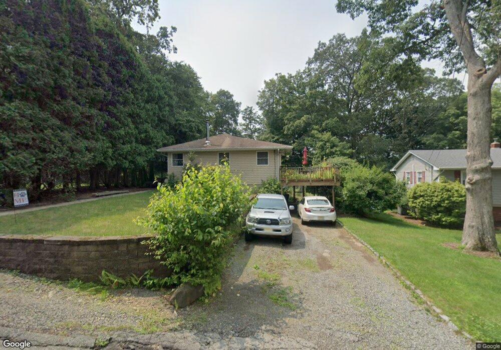
610 Stanley Place Landing, NJ 07850
Estimated Value: $416,713 - $491,000
--
Bed
--
Bath
1,224
Sq Ft
$372/Sq Ft
Est. Value
About This Home
This home is located at 610 Stanley Place, Landing, NJ 07850 and is currently estimated at $455,428, approximately $372 per square foot. 610 Stanley Place is a home located in Morris County with nearby schools including Edith M. Decker Elementary School, Mt. Arlington Public School, and Elite Prepartory Academy.
Ownership History
Date
Name
Owned For
Owner Type
Purchase Details
Closed on
Oct 30, 2001
Sold by
Koch Wayne
Bought by
Bielawski Edward and Bielawski Michele
Current Estimated Value
Home Financials for this Owner
Home Financials are based on the most recent Mortgage that was taken out on this home.
Original Mortgage
$124,800
Outstanding Balance
$48,706
Interest Rate
6.7%
Estimated Equity
$406,722
Purchase Details
Closed on
Nov 1, 1995
Sold by
Day James G and Day Leona B
Bought by
Koch Wayne R
Create a Home Valuation Report for This Property
The Home Valuation Report is an in-depth analysis detailing your home's value as well as a comparison with similar homes in the area
Home Values in the Area
Average Home Value in this Area
Purchase History
| Date | Buyer | Sale Price | Title Company |
|---|---|---|---|
| Bielawski Edward | $160,000 | -- | |
| Koch Wayne R | $120,000 | -- |
Source: Public Records
Mortgage History
| Date | Status | Borrower | Loan Amount |
|---|---|---|---|
| Open | Bielawski Edward | $124,800 |
Source: Public Records
Tax History Compared to Growth
Tax History
| Year | Tax Paid | Tax Assessment Tax Assessment Total Assessment is a certain percentage of the fair market value that is determined by local assessors to be the total taxable value of land and additions on the property. | Land | Improvement |
|---|---|---|---|---|
| 2025 | $6,008 | $295,100 | $132,300 | $162,800 |
| 2024 | $5,769 | $295,100 | $132,300 | $162,800 |
| 2023 | $5,769 | $295,100 | $132,300 | $162,800 |
| 2022 | $5,888 | $215,200 | $127,500 | $87,700 |
| 2021 | $5,888 | $215,200 | $127,500 | $87,700 |
| 2020 | $5,789 | $215,200 | $127,500 | $87,700 |
| 2019 | $5,671 | $215,200 | $127,500 | $87,700 |
| 2018 | $5,658 | $215,200 | $127,500 | $87,700 |
| 2017 | $5,593 | $215,200 | $127,500 | $87,700 |
| 2016 | $5,582 | $215,200 | $127,500 | $87,700 |
| 2015 | $5,485 | $215,200 | $127,500 | $87,700 |
| 2014 | $5,423 | $215,200 | $127,500 | $87,700 |
Source: Public Records
Map
Nearby Homes
- 537 Dell Rd
- 649 Henmar Dr
- 592 Dell Rd
- 547 Atlas Rd
- 512 Colver Rd
- 504 Ryerson Rd
- 627 E Vail Rd
- 505 Logan Dr
- 21 Laurie Rd
- 15 Auriemma Ct
- 5 Zachary Dr
- 100 Zachary Way Unit 100
- 203 Howard Blvd
- 33 Ford Rd Unit 35
- 305 Kingsland Rd
- 16 Esposito Ln
- 24 Bertrand Island Rd
- 86 Brookside Ln
- 90 Salmon Rd
- 11 Zachary Way
- 608 Stanley Place
- 612 Stanley Place
- 604 Stanley Place
- 614 Stanley Place
- 625 Henmar Dr
- 602 Dorothy Ln
- 621 Henmar Dr
- 605 Stanley Place
- 609 Stanley Place
- 627 Henmar Dr
- 619 Henmar Dr
- 629 Henmar Dr
- 603 Dorothy Ln
- 602 Stanley Place
- 615 Henmar Dr
- 631 Henmar Dr
- 603 Stanley Place
- 545 Eric Ln
- 618 Stanley Place
- 604 Dorothy Ln