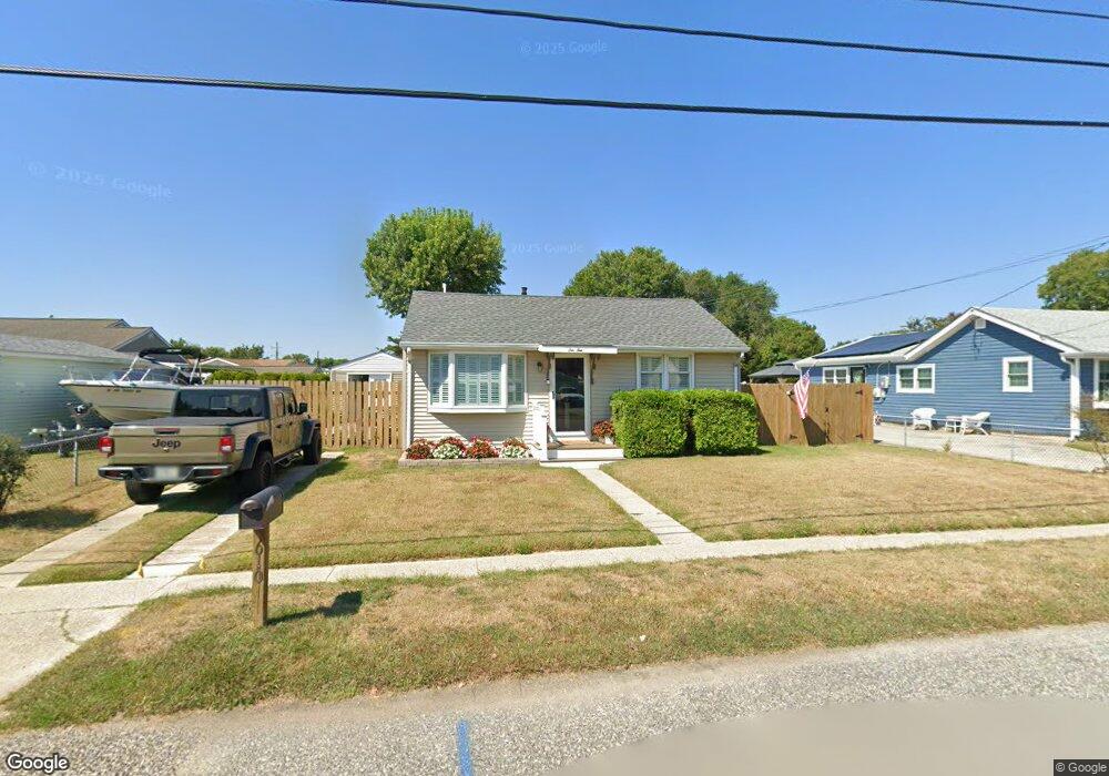
610 Wilson Ave Cape May, NJ 08204
Estimated Value: $435,397 - $514,000
--
Bed
--
Bath
716
Sq Ft
$659/Sq Ft
Est. Value
About This Home
This home is located at 610 Wilson Ave, Cape May, NJ 08204 and is currently estimated at $471,849, approximately $659 per square foot. 610 Wilson Ave is a home located in Cape May County with nearby schools including Carl T. Mitnick School, David C. Douglass Veterans Memorial School, and Maud Abrams School.
Ownership History
Date
Name
Owned For
Owner Type
Purchase Details
Closed on
Sep 25, 2018
Sold by
Widerstrom Carolyn A and Lazaro Carolyn
Bought by
Widerstrom Carolyn A
Current Estimated Value
Purchase Details
Closed on
Mar 11, 2016
Sold by
Lazaro Michael L and Lazaro Carolyn
Bought by
Lazaro Carolyn
Purchase Details
Closed on
Oct 25, 2013
Sold by
Clark Crandall A and Clark Elizabeth A
Bought by
Lazaro Michael L
Home Financials for this Owner
Home Financials are based on the most recent Mortgage that was taken out on this home.
Original Mortgage
$145,502
Interest Rate
4.24%
Mortgage Type
FHA
Purchase Details
Closed on
Apr 19, 2012
Sold by
Trego Joseph W and Trego Philip J
Bought by
Clark Crandall A and Clark Elizabeth A
Home Financials for this Owner
Home Financials are based on the most recent Mortgage that was taken out on this home.
Original Mortgage
$45,000
Interest Rate
3.91%
Mortgage Type
New Conventional
Create a Home Valuation Report for This Property
The Home Valuation Report is an in-depth analysis detailing your home's value as well as a comparison with similar homes in the area
Home Values in the Area
Average Home Value in this Area
Purchase History
| Date | Buyer | Sale Price | Title Company |
|---|---|---|---|
| Widerstrom Carolyn A | -- | -- | |
| Lazaro Carolyn | -- | None Available | |
| Lazaro Michael L | $178,000 | Group 21 Title Agency | |
| Clark Crandall A | $175,000 | Shore Title Agency Inc |
Source: Public Records
Mortgage History
| Date | Status | Borrower | Loan Amount |
|---|---|---|---|
| Previous Owner | Lazaro Michael L | $145,502 | |
| Previous Owner | Clark Crandall A | $45,000 |
Source: Public Records
Tax History Compared to Growth
Tax History
| Year | Tax Paid | Tax Assessment Tax Assessment Total Assessment is a certain percentage of the fair market value that is determined by local assessors to be the total taxable value of land and additions on the property. | Land | Improvement |
|---|---|---|---|---|
| 2025 | $3,417 | $168,500 | $117,300 | $51,200 |
| 2024 | $3,417 | $168,500 | $117,300 | $51,200 |
| 2023 | $3,368 | $168,500 | $117,300 | $51,200 |
| 2022 | $3,266 | $168,500 | $117,300 | $51,200 |
| 2021 | $3,168 | $168,500 | $117,300 | $51,200 |
| 2020 | $3,117 | $168,500 | $117,300 | $51,200 |
| 2019 | $3,040 | $168,500 | $117,300 | $51,200 |
| 2018 | $2,967 | $168,500 | $117,300 | $51,200 |
| 2017 | $2,971 | $168,500 | $117,300 | $51,200 |
| 2016 | $2,925 | $168,500 | $117,300 | $51,200 |
| 2015 | $2,831 | $168,500 | $117,300 | $51,200 |
| 2014 | $2,738 | $168,500 | $117,300 | $51,200 |
Source: Public Records
Map
Nearby Homes
- 712 Indian Ave
- 1400 Franklin Ave
- 508 Adriatic Ave
- 1500 Franklin Ave
- 602 Gorham Ave
- 402 Whildam Ave
- 712 Gorham Ave
- 702 Gordon Terrace
- 711 Beach Dr
- 507 Scotty Blvd Unit 12
- 503 Beach Dr
- 305 Whildam Ave
- 401 Beach Dr
- 1310 Browning Ave
- 1607 Scott Ave
- 113 Beachhurst Dr
- 219 Town Bank Rd
- 3911 Bayshore Rd
- 66 Beachhurst Dr
- 105 Orchard Dr
- 608 Wilson Ave
- 1001 Rosehill Pkwy
- 1003 Rosehill Pkwy
- 1005 Rosehill Pkwy
- 606 Wilson Ave
- 611 Wayne Ave
- 609 Wayne Ave
- 903 Rosehill Pkwy
- 607 Wayne Ave
- 611 Wilson Ave
- 1007 Rosehill Pkwy
- 903 Rose Hill Pkwy
- 609 Wilson Ave
- 604 Wilson Ave
- 605 Wayne Ave
- 901 Rosehill Pkwy
- 906 Rosehill Pkwy
- 906 Rose Hill Pkwy
- 605 Wilson Ave
- 603 Wayne Ave