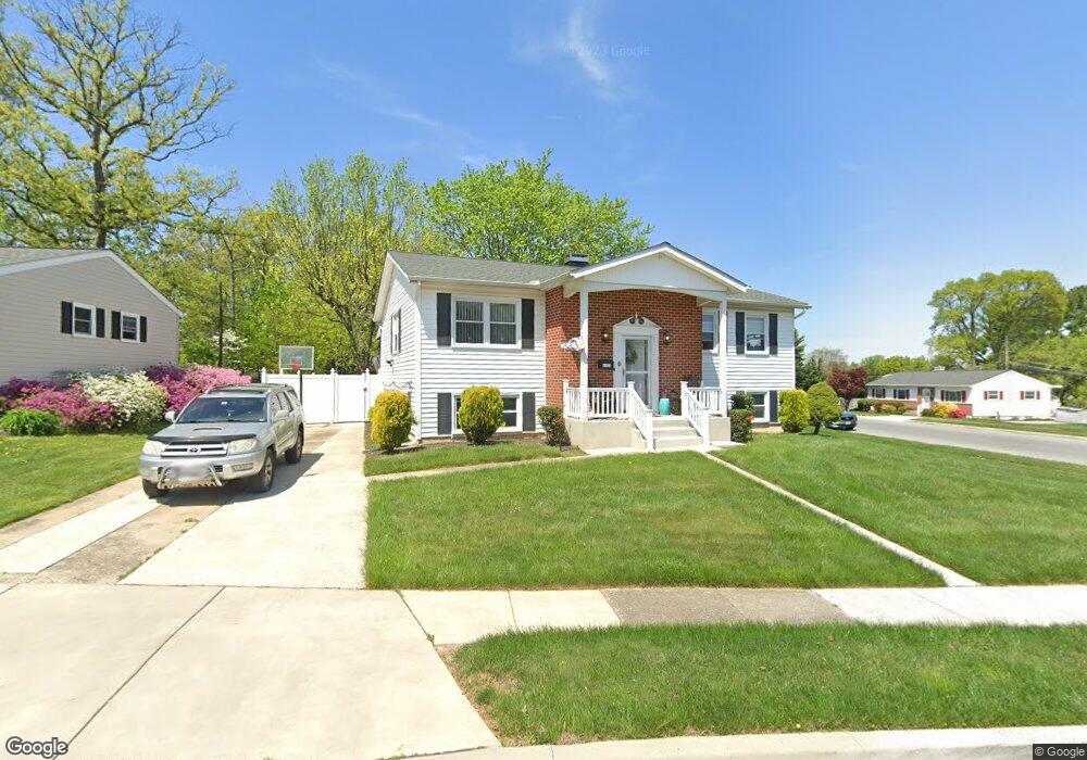
6100 Burnt Oak Rd Catonsville, MD 21228
Estimated Value: $345,251 - $448,000
--
Bed
2
Baths
1,278
Sq Ft
$312/Sq Ft
Est. Value
About This Home
This home is located at 6100 Burnt Oak Rd, Catonsville, MD 21228 and is currently estimated at $398,313, approximately $311 per square foot. 6100 Burnt Oak Rd is a home located in Baltimore County with nearby schools including Woodbridge Elementary School, Southwest Academy, and Woodlawn High School.
Ownership History
Date
Name
Owned For
Owner Type
Purchase Details
Closed on
Oct 28, 2019
Sold by
Ripple Audrey Marie and Stone Cynthia R
Bought by
Ripple William F
Current Estimated Value
Purchase Details
Closed on
Jul 15, 2019
Sold by
Ripple William F and Stone Cynthia R
Bought by
Ripple Audrey Marie
Purchase Details
Closed on
Apr 15, 2016
Sold by
Ripple Audrey Marie
Bought by
Ripple William F and Stone Cynthia R
Purchase Details
Closed on
Nov 25, 1998
Sold by
Ripple Francis X
Bought by
Ripple Francis X and Ripple Audrey M
Purchase Details
Closed on
Sep 12, 1997
Sold by
Ripple Francis X
Bought by
Ripple Francis X and Ripple Audrey M
Purchase Details
Closed on
Apr 24, 1963
Sold by
Deerfield Constr Uction Company In
Bought by
Ripple Francis X
Create a Home Valuation Report for This Property
The Home Valuation Report is an in-depth analysis detailing your home's value as well as a comparison with similar homes in the area
Home Values in the Area
Average Home Value in this Area
Purchase History
| Date | Buyer | Sale Price | Title Company |
|---|---|---|---|
| Ripple William F | -- | Accommodation | |
| Ripple Audrey Marie | -- | Freestate Ttl Consultats Llc | |
| Ripple William F | -- | Attorney | |
| Ripple Francis X | -- | -- | |
| Ripple Francis X | -- | -- | |
| Ripple Francis X | $23,000 | -- |
Source: Public Records
Tax History Compared to Growth
Tax History
| Year | Tax Paid | Tax Assessment Tax Assessment Total Assessment is a certain percentage of the fair market value that is determined by local assessors to be the total taxable value of land and additions on the property. | Land | Improvement |
|---|---|---|---|---|
| 2025 | $4,094 | $301,133 | -- | -- |
| 2024 | $4,094 | $283,400 | $78,600 | $204,800 |
| 2023 | $2,010 | $269,967 | $0 | $0 |
| 2022 | $3,894 | $256,533 | $0 | $0 |
| 2021 | $3,521 | $243,100 | $78,600 | $164,500 |
| 2020 | $3,769 | $237,833 | $0 | $0 |
| 2019 | $2,819 | $232,567 | $0 | $0 |
| 2018 | $3,704 | $227,300 | $65,100 | $162,200 |
| 2017 | $3,325 | $217,967 | $0 | $0 |
| 2016 | $2,474 | $208,633 | $0 | $0 |
| 2015 | $2,474 | $199,300 | $0 | $0 |
| 2014 | $2,474 | $199,300 | $0 | $0 |
Source: Public Records
Map
Nearby Homes
- 6031 Burnt Oak Rd
- 6200 Gilston Park Rd
- 800 Crosby Rd
- 3 Mcgrady Square
- 6263 Gilston Park Rd
- 1111 Cummings Ave
- 6028 Moorehead Rd
- 67 Walden Mill Way
- 1019 Cummings Ave
- 1418 Harberson Rd
- 1013 Cummings Ave
- 908 Vanderwood Rd
- 920 Vanderwood Rd
- 1009 Rowe Ln
- 930 Sedgley Rd
- 1007 Kent Ave
- 5926 Old Frederick Rd
- 353 N Beaumont Ave
- 2100 Chantilla Rd
- 6011 Johnnycake Rd
- 6102 Burnt Oak Rd
- 6111 Collinsway Rd
- 6105 Collinsway Rd
- 6113 Collinsway Rd
- 6104 Burnt Oak Rd Unit 1ST FLOOR
- 6108 Collinsway Rd
- 1303 Pineburn Ct
- 6036 Burnt Oak Rd
- 6103 Burnt Oak Rd
- 6104 Collinsway Rd
- 6103 Collinsway Rd
- 6115 Collinsway Rd
- 1301 Middleford Rd
- 1305 Pineburn Ct
- 6102 Collinsway Rd
- 6034 Burnt Oak Rd
- 6117 Collinsway Rd
- 1303 Middleford Rd
- 6101 Collinsway Rd