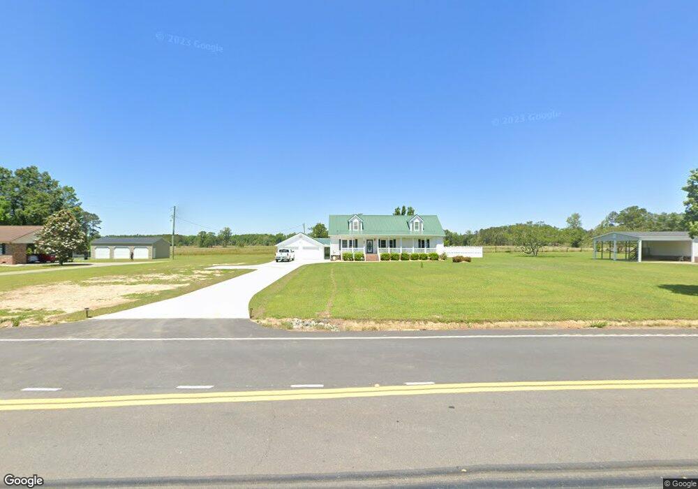
6100 Kates Bay Hwy Conway, SC 29527
Estimated Value: $316,794 - $365,000
3
Beds
2
Baths
1,568
Sq Ft
$216/Sq Ft
Est. Value
About This Home
This home is located at 6100 Kates Bay Hwy, Conway, SC 29527 and is currently estimated at $338,199, approximately $215 per square foot. 6100 Kates Bay Hwy is a home located in Horry County with nearby schools including Pee Dee Elementary School, Whittemore Park Middle School, and Conway High School.
Ownership History
Date
Name
Owned For
Owner Type
Purchase Details
Closed on
May 17, 2017
Sold by
Tyner Timothy Norris
Bought by
Tyner Timothy N and Tyner Rhonda F
Current Estimated Value
Purchase Details
Closed on
Aug 19, 2011
Sold by
Tyner Cynthia D
Bought by
Tyner Timothy Norris
Purchase Details
Closed on
Oct 25, 2010
Sold by
Tyner Timothy Charles
Bought by
Tyner Timothy Charles
Purchase Details
Closed on
Jul 20, 2009
Sold by
Tyner Timothy Norris
Bought by
Tyner Timothy Charles
Create a Home Valuation Report for This Property
The Home Valuation Report is an in-depth analysis detailing your home's value as well as a comparison with similar homes in the area
Home Values in the Area
Average Home Value in this Area
Purchase History
| Date | Buyer | Sale Price | Title Company |
|---|---|---|---|
| Tyner Timothy N | -- | -- | |
| Tyner Timothy Norris | -- | -- | |
| Tyner Timothy Charles | -- | -- | |
| Tyner Timothy Charles | -- | -- |
Source: Public Records
Tax History Compared to Growth
Tax History
| Year | Tax Paid | Tax Assessment Tax Assessment Total Assessment is a certain percentage of the fair market value that is determined by local assessors to be the total taxable value of land and additions on the property. | Land | Improvement |
|---|---|---|---|---|
| 2024 | -- | $19,290 | $5,227 | $14,063 |
| 2023 | $0 | $7,768 | $900 | $6,868 |
| 2021 | $635 | $11,652 | $1,350 | $10,302 |
| 2020 | $546 | $11,652 | $1,350 | $10,302 |
| 2019 | $546 | $14,274 | $1,350 | $12,924 |
| 2018 | $471 | $10,134 | $1,110 | $9,024 |
| 2017 | $497 | $7,836 | $1,110 | $6,726 |
| 2016 | -- | $7,836 | $1,110 | $6,726 |
| 2015 | $497 | $5,224 | $740 | $11,771 |
| 2014 | $479 | $8,196 | $1,110 | $7,086 |
Source: Public Records
Map
Nearby Homes
- 297 Harvest Ridge Way
- 232 Harvest Ridge Way
- 380 Harvest Ridge Way
- 1031 Corn Husk Loop
- 128 Coralberry Dr
- 131 Coralberry Dr
- 540 Scarlet Sage Dr
- 544 Scarlet Sage Dr
- 123 Coralberry Dr
- 343 Black Gum Dr
- 318 Black Gum Dr
- 331 Black Gum Dr
- 327 Black Gum Dr
- 310 Black Gum Dr
- 109 Rena Ln Unit Lot 3
- ARIA Plan at Dove Crossing
- CALI Plan at Dove Crossing
- MANNING Plan at Dove Crossing
- KERRY Plan at Dove Crossing
- GALEN Plan at Dove Crossing
- 6114 Kates Bay Hwy
- 6095 Cates Bay Hwy
- 6088 Kates Bay Hwy
- 6087 Kates Bay Hwy
- 6115 Cates Bay Hwy
- 264 Harvest Ridge Way
- 6080 Kates Bay Hwy
- 6120 Kates Bay Hwy
- 6081 Cates Bay Hwy
- 253 Harvest Rdg Way
- 240 Harvest Ridge Way Unit Lot 105- Aria A
- 249 Harvest Rdg Way
- 281 Harvest Ridge Way
- 281 Harvest Ridge Way Unit Lot 133- Macon A
- 6121 Cates Bay Hwy
- 111 Spring Wheat Way
- 111 Spring Wheat Way Unit Lot 125- Aria A
- 293 Harvest Rdg Way
- 6000 Kates Bay Hwy
- 6145 Cates Bay Hwy