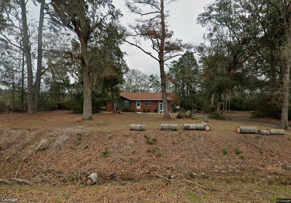
6100 Moultrie Hwy Quitman, GA 31643
Estimated Value: $108,000 - $233,000
Studio
1
Bath
1,112
Sq Ft
$137/Sq Ft
Est. Value
About This Home
This home is located at 6100 Moultrie Hwy, Quitman, GA 31643 and is currently estimated at $152,142, approximately $136 per square foot. 6100 Moultrie Hwy is a home located in Brooks County with nearby schools including North Brooks Elementary School.
Ownership History
Date
Name
Owned For
Owner Type
Purchase Details
Closed on
Aug 29, 2002
Sold by
Bibin Mary M and Bibin Frank S
Bought by
Pace Ii Roy Kenneth
Current Estimated Value
Purchase Details
Closed on
Oct 13, 1995
Sold by
Carter Dorothy
Bought by
Bibin Mary Margaret and Bibin Frank S
Purchase Details
Closed on
Dec 14, 1994
Sold by
Carter Dorothy Etal
Bought by
Carter Dorothy
Purchase Details
Closed on
May 9, 1984
Sold by
Carter Dorothy Etal
Bought by
Carter Dorothy Etal
Create a Home Valuation Report for This Property
The Home Valuation Report is an in-depth analysis detailing your home's value as well as a comparison with similar homes in the area
Purchase History
| Date | Buyer | Sale Price | Title Company |
|---|---|---|---|
| Pace Ii Roy Kenneth | $46,600 | -- | |
| Bibin Mary Margaret | $45,000 | -- | |
| Carter Dorothy | -- | -- | |
| Carter Dorothy Etal | -- | -- |
Source: Public Records
Tax History
| Year | Tax Paid | Tax Assessment Tax Assessment Total Assessment is a certain percentage of the fair market value that is determined by local assessors to be the total taxable value of land and additions on the property. | Land | Improvement |
|---|---|---|---|---|
| 2025 | $1,263 | $38,000 | $5,800 | $32,200 |
| 2024 | $1,263 | $38,000 | $5,800 | $32,200 |
| 2023 | $718 | $34,600 | $5,040 | $29,560 |
| 2022 | $1,189 | $32,160 | $4,800 | $27,360 |
| 2021 | $979 | $26,240 | $4,960 | $21,280 |
| 2020 | $741 | $26,680 | $4,960 | $21,720 |
| 2019 | $865 | $23,440 | $4,800 | $18,640 |
| 2018 | $695 | $23,800 | $4,800 | $19,000 |
| 2017 | $826 | $23,080 | $4,800 | $18,280 |
| 2016 | $871 | $23,440 | $4,800 | $18,640 |
| 2015 | -- | $23,560 | $4,800 | $18,760 |
| 2014 | -- | $24,240 | $4,800 | $19,440 |
| 2013 | -- | $24,240 | $4,800 | $19,440 |
Source: Public Records
Map
Nearby Homes
- 1521 Mount Carmel Chuch Rx
- 2430 Spain Rd
- 1019 Fodie Rd
- 237 Turkey Ridge Ln
- 2661 Dewberry Rd
- 103 Victorian Way
- 714 Morris Ave
- 204 Oak St
- 807 N Court St
- 506 Oglesby St
- 179 Baker St
- 606 N Court St
- 700 N Washington St
- 1501 W Screven St
- 103 Magnolia Dr
- 103 Camellia Dr
- 2466 Dunn Rd
- 0 E Gordon St
- Lot 14 Dawn Ln
- 203 N Clay St
Your Personal Tour Guide
Ask me questions while you tour the home.