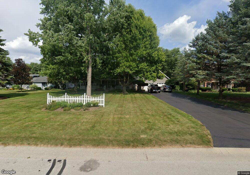
6105 Forest Edge Dr Whitehouse, OH 43571
West Lucas County NeighborhoodEstimated Value: $507,836 - $580,000
4
Beds
3
Baths
2,800
Sq Ft
$192/Sq Ft
Est. Value
About This Home
This home is located at 6105 Forest Edge Dr, Whitehouse, OH 43571 and is currently estimated at $537,459, approximately $191 per square foot. 6105 Forest Edge Dr is a home located in Lucas County with nearby schools including Anthony Wayne High School and Lial Catholic School.
Ownership History
Date
Name
Owned For
Owner Type
Purchase Details
Closed on
Jun 29, 2006
Sold by
Meier Douglas W and Meier Wendy S
Bought by
Sharp Jeffery E and Sharp Tricia L
Current Estimated Value
Home Financials for this Owner
Home Financials are based on the most recent Mortgage that was taken out on this home.
Original Mortgage
$59,980
Interest Rate
6.68%
Mortgage Type
Purchase Money Mortgage
Purchase Details
Closed on
Jan 10, 1990
Create a Home Valuation Report for This Property
The Home Valuation Report is an in-depth analysis detailing your home's value as well as a comparison with similar homes in the area
Home Values in the Area
Average Home Value in this Area
Purchase History
| Date | Buyer | Sale Price | Title Company |
|---|---|---|---|
| Sharp Jeffery E | $299,900 | None Available | |
| -- | $25,000 | -- |
Source: Public Records
Mortgage History
| Date | Status | Borrower | Loan Amount |
|---|---|---|---|
| Closed | Sharp Jeffery E | $59,980 |
Source: Public Records
Tax History Compared to Growth
Tax History
| Year | Tax Paid | Tax Assessment Tax Assessment Total Assessment is a certain percentage of the fair market value that is determined by local assessors to be the total taxable value of land and additions on the property. | Land | Improvement |
|---|---|---|---|---|
| 2024 | $3,497 | $142,450 | $21,455 | $120,995 |
| 2023 | $5,708 | $105,000 | $18,690 | $86,310 |
| 2022 | $5,763 | $105,000 | $18,690 | $86,310 |
| 2021 | $6,519 | $117,845 | $18,690 | $99,155 |
| 2020 | $6,206 | $100,380 | $15,855 | $84,525 |
| 2019 | $5,698 | $100,380 | $15,855 | $84,525 |
| 2018 | $5,310 | $100,380 | $15,855 | $84,525 |
| 2017 | $5,269 | $86,625 | $18,515 | $68,110 |
| 2016 | $5,213 | $247,500 | $52,900 | $194,600 |
| 2015 | $4,978 | $247,500 | $52,900 | $194,600 |
| 2014 | $5,017 | $85,790 | $18,340 | $67,450 |
| 2013 | $5,017 | $85,790 | $18,340 | $67,450 |
Source: Public Records
Map
Nearby Homes
- 10751 Brexton Ct
- 10700 Brexton Ct
- 10706 Brexton Ct
- 10701 Brexton Ct
- 6306 Weckerly Rd
- 6414 Lenderson Ave
- 5935 Lynwood Ct
- 6547 Lenderson Ave
- 5901 Wildwood Ln
- 6316 Pimlico Rd
- 7002 Red Stag Ct
- 6715 Oakbrook Dr
- 11149 West St
- 5908 Finzel Rd
- 6935 Big Buck Trail
- 6746 Oak Crossing Ln
- 10160 Blue Creek S
- 6951 Red Stag Ct
- 11158 Whitetail Way
- 6952 Red Stag Ct
- 6115 Forest Edge Dr
- 6061 Forest Edge Dr
- 6127 Forest Edge Dr
- 6053 Forest Edge Dr
- 6106 Forest Edge Dr
- 6062 Forest Edge Dr
- 6116 Forest Edge Dr
- 6047 Forest Edge Dr
- 6137 Forest Edge Dr
- 6052 Forest Edge Dr
- 6126 Forest Edge Dr
- 10844 Pine Vista Dr
- 6136 Forest Edge Dr
- 6149 Forest Edge Dr
- 10850 Pine Vista Dr
- 6146 Forest Edge Dr
- 6155 Forest Edge Dr
- 10862 Little Creek Dr
- 6163 Forest Edge Dr
- 10746 Brexton Ct