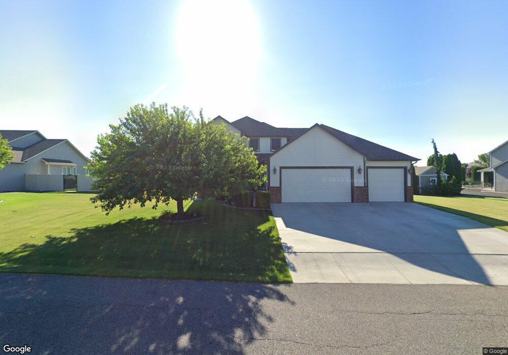
6108 W Lattin Rd West Richland, WA 99353
Estimated Value: $665,938 - $776,000
4
Beds
3
Baths
3,028
Sq Ft
$242/Sq Ft
Est. Value
About This Home
This home is located at 6108 W Lattin Rd, West Richland, WA 99353 and is currently estimated at $733,735, approximately $242 per square foot. 6108 W Lattin Rd is a home located in Benton County with nearby schools including White Bluffs Elementary School, Enterprise Middle School, and Richland High School.
Ownership History
Date
Name
Owned For
Owner Type
Purchase Details
Closed on
Sep 24, 2010
Sold by
Baker Cornelius E
Bought by
Baker Cornelius E and Baker Shelly A
Current Estimated Value
Home Financials for this Owner
Home Financials are based on the most recent Mortgage that was taken out on this home.
Original Mortgage
$300,500
Outstanding Balance
$197,521
Interest Rate
4.35%
Mortgage Type
New Conventional
Estimated Equity
$536,214
Purchase Details
Closed on
Aug 6, 2008
Sold by
Baker Shelly A
Bought by
Baker Cornelius E
Home Financials for this Owner
Home Financials are based on the most recent Mortgage that was taken out on this home.
Original Mortgage
$297,990
Interest Rate
6.37%
Mortgage Type
Purchase Money Mortgage
Create a Home Valuation Report for This Property
The Home Valuation Report is an in-depth analysis detailing your home's value as well as a comparison with similar homes in the area
Home Values in the Area
Average Home Value in this Area
Purchase History
| Date | Buyer | Sale Price | Title Company |
|---|---|---|---|
| Baker Cornelius E | -- | Cascade Title | |
| Baker Cornelius E | -- | Stewart Title | |
| Baker Cornelius E | $313,681 | Stewart Title |
Source: Public Records
Mortgage History
| Date | Status | Borrower | Loan Amount |
|---|---|---|---|
| Open | Baker Cornelius E | $300,500 | |
| Closed | Baker Cornelius E | $297,990 |
Source: Public Records
Tax History Compared to Growth
Tax History
| Year | Tax Paid | Tax Assessment Tax Assessment Total Assessment is a certain percentage of the fair market value that is determined by local assessors to be the total taxable value of land and additions on the property. | Land | Improvement |
|---|---|---|---|---|
| 2024 | $5,151 | $561,890 | $60,000 | $501,890 |
| 2023 | $5,151 | $484,680 | $60,000 | $424,680 |
| 2022 | $5,025 | $433,200 | $60,000 | $373,200 |
| 2021 | $4,918 | $407,460 | $60,000 | $347,460 |
| 2020 | $4,949 | $381,730 | $60,000 | $321,730 |
| 2019 | $4,698 | $368,860 | $60,000 | $308,860 |
| 2018 | $4,660 | $375,870 | $56,000 | $319,870 |
| 2017 | $4,146 | $322,560 | $56,000 | $266,560 |
| 2016 | $4,431 | $322,560 | $56,000 | $266,560 |
| 2015 | $4,490 | $322,560 | $56,000 | $266,560 |
| 2014 | -- | $322,560 | $56,000 | $266,560 |
| 2013 | -- | $322,560 | $56,000 | $266,560 |
Source: Public Records
Map
Nearby Homes
- 5600 Kirkwood Ln
- 6363 Keene Rd
- 6397 Keene Rd
- 6461 Keene Rd
- 5507 Monica St
- 1120 Keene Rd
- 3538 Curtis Dr
- 5258 Chris St
- 5200 S Desert Dove Loop
- 3000 S Highlands Blvd
- 5420 Hershey Ln
- 3909 Curtis Dr
- 6062 Juneberry Dr
- 5007 S Desert Dove Loop
- 5330 Hershey Ln
- 5506 Aspen Dr
- 5705 Aspen Dr
- 6273 Teak Ln
- 6268 Teak Ln
- 5002 Spirea Dr
- 6116 W Lattin Rd
- 6100 W Lattin Loop
- 6122 W Lattin Rd
- 5702 Glenbrook Loop
- 5904 Thynewood Loop
- 5907 Thynewood Loop
- 5700 Glenbrook Loop
- 5706 Glenbrook Loop
- 6096 Thynewood Loop
- 5900 Lanay St
- 5918 Thynewood Loop
- 5925 Thynewood Loop
- 5925 Thynewood Loop
- 6134 W Lattin Rd
- 6084 Thynewood Loop
- 5604 Glenbrook Loop
- 6002 W Lattin Loop
- 5800 Glenbrook Loop Unit 50x60 Shop on .93 ac
- 5800 Glenbrook Loop Unit 60x50 Shop! .93 of a
- 5800 Glenbrook Loop