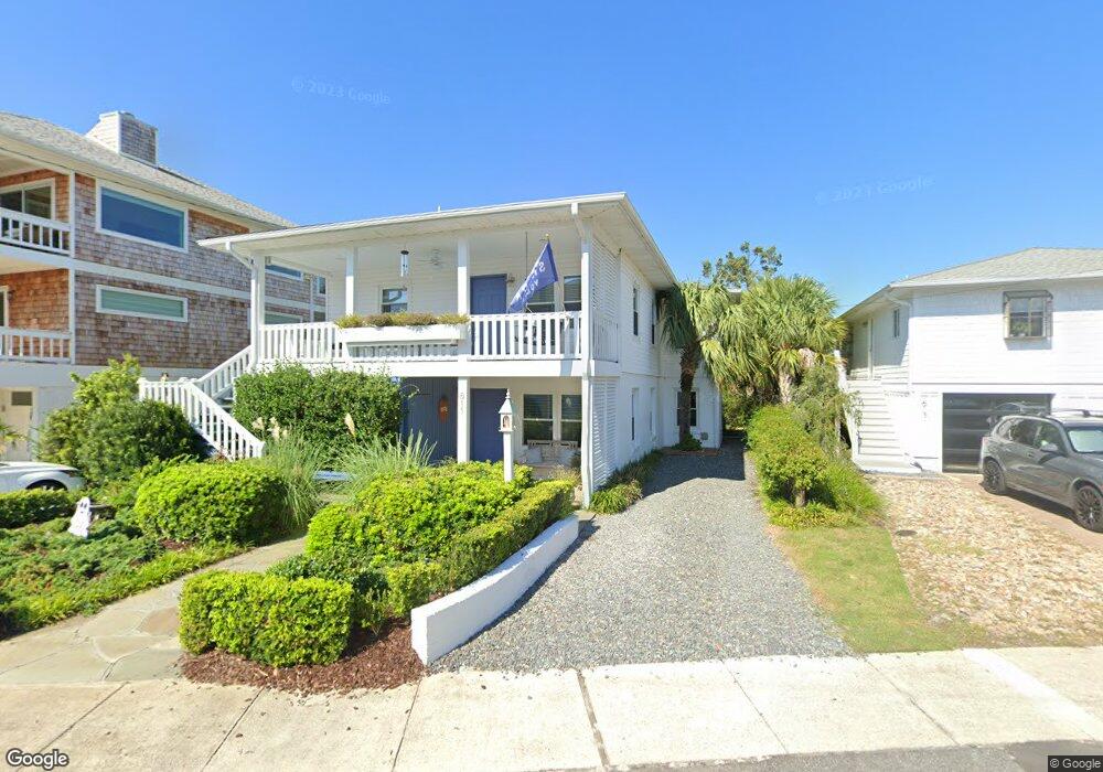
611 N Channel Dr Wrightsville Beach, NC 28480
Estimated Value: $1,748,384 - $1,915,000
4
Beds
3
Baths
2,260
Sq Ft
$802/Sq Ft
Est. Value
About This Home
This home is located at 611 N Channel Dr, Wrightsville Beach, NC 28480 and is currently estimated at $1,811,596, approximately $801 per square foot. 611 N Channel Dr is a home located in New Hanover County with nearby schools including Wrightsville Beach Elementary School, M.C.S. Noble Middle School, and John T. Hoggard High School.
Ownership History
Date
Name
Owned For
Owner Type
Purchase Details
Closed on
Sep 12, 2005
Sold by
Cox Kenneth E
Bought by
Bloomquist Mark P
Current Estimated Value
Purchase Details
Closed on
Oct 26, 1998
Sold by
Cox Kenneth E
Bought by
Cox Kenneth E
Purchase Details
Closed on
Jun 15, 1993
Sold by
Fields Robert Michael Patricia
Bought by
Cox Kenneth E
Purchase Details
Closed on
May 1, 1985
Sold by
Bullock Cynthia B
Bought by
Fields Robert Michael
Purchase Details
Closed on
Dec 1, 1983
Sold by
Keniston Henry E Hrs
Bought by
Bullock Cynthia B
Create a Home Valuation Report for This Property
The Home Valuation Report is an in-depth analysis detailing your home's value as well as a comparison with similar homes in the area
Home Values in the Area
Average Home Value in this Area
Purchase History
| Date | Buyer | Sale Price | Title Company |
|---|---|---|---|
| Bloomquist Mark P | $760,000 | None Available | |
| Cox Kenneth E | -- | -- | |
| Cox Kenneth E | $159,000 | -- | |
| Fields Robert Michael | $92,000 | -- | |
| Bullock Cynthia B | $78,000 | -- |
Source: Public Records
Tax History Compared to Growth
Tax History
| Year | Tax Paid | Tax Assessment Tax Assessment Total Assessment is a certain percentage of the fair market value that is determined by local assessors to be the total taxable value of land and additions on the property. | Land | Improvement |
|---|---|---|---|---|
| 2025 | $4,377 | $1,218,900 | $968,400 | $250,500 |
| 2023 | $4,107 | $757,300 | $608,300 | $149,000 |
| 2022 | $4,145 | $757,300 | $608,300 | $149,000 |
| 2021 | $4,296 | $757,300 | $608,300 | $149,000 |
| 2020 | $3,086 | $452,200 | $237,100 | $215,100 |
| 2019 | $3,086 | $452,200 | $237,100 | $215,100 |
| 2018 | $3,086 | $452,200 | $237,100 | $215,100 |
| 2017 | $3,154 | $452,200 | $237,100 | $215,100 |
| 2016 | $3,271 | $432,700 | $326,900 | $105,800 |
| 2015 | $3,059 | $432,700 | $326,900 | $105,800 |
| 2014 | $2,973 | $432,700 | $326,900 | $105,800 |
Source: Public Records
Map
Nearby Homes
- 612 N Channel Dr
- 21 W Henderson St
- 21 W Henderson St Unit A&B
- 3 W Greensboro St Unit A
- 801 N Lumina Ave
- 13 E Fayetteville St
- 1 Bay St
- 108 N Channel Dr
- 22 Lagoon Dr
- 16 E Henderson St Unit A
- 4 Heron St Unit A
- 9 W Atlanta St
- 13 Seagull St Unit B
- 11 Shearwater St Unit A
- 10 Columbia St W Unit A
- 105 N Lumina Ave Unit B
- 106 Lumina Ave S Unit 2
- 104 Lumina Ave S Unit 406
- 104 Lumina Ave S Unit 103
- 101 Lumina Ave S Unit Th 10
- 609 N Channel Dr
- 605 N Channel Dr
- 19 Lookout Harbor Unit 19
- 608 N Channel Dr
- 21 Lookout Harbor
- 16 Lookout Harbor
- 20 Lookout Harbor
- 24 Lookout Harbor
- 23 Lookout Harbor
- 15 Lookout Harbor
- 22 Lookout Harbor Unit 22
- 18 Lookout Harbor
- 17 Lookout Harbor
- 13 Lookout Harbor Unit WAY
- 14 Lookout Harbor
- 601 N Channel Dr
- 602 N Channel Dr
- 10 Lookout Harbor
- 7 Lookout Harbor Unit 7