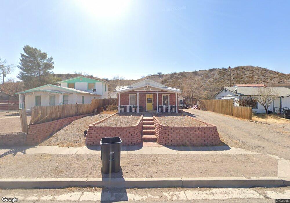
611 SE Old Hwy W Duncan, AZ 85534
Estimated Value: $111,357 - $174,000
3
Beds
1
Bath
1,200
Sq Ft
$124/Sq Ft
Est. Value
About This Home
This home is located at 611 SE Old Hwy W, Duncan, AZ 85534 and is currently estimated at $149,089, approximately $124 per square foot. 611 SE Old Hwy W is a home located in Greenlee County with nearby schools including Duncan Elementary School and Duncan High School.
Ownership History
Date
Name
Owned For
Owner Type
Purchase Details
Closed on
Apr 19, 2021
Sold by
Cox Randall Adam
Bought by
Cox Randall Adam and Cox Melody Lee
Current Estimated Value
Purchase Details
Closed on
Apr 3, 2021
Sold by
Littlefield Brent
Bought by
Cox Randal Adam
Purchase Details
Closed on
Mar 5, 2015
Sold by
Littlefield Brent
Bought by
Cox Randall Adam and Cox Melody Lee
Purchase Details
Closed on
Aug 12, 2013
Sold by
Bradfute Michael J
Bought by
Littlefield Brent L
Purchase Details
Closed on
Aug 23, 2006
Sold by
Santee Donald and Santee Flossie
Bought by
Bradfute Michasel J
Purchase Details
Closed on
Aug 10, 2006
Sold by
Richins Robert D
Bought by
Santee Flossie I
Create a Home Valuation Report for This Property
The Home Valuation Report is an in-depth analysis detailing your home's value as well as a comparison with similar homes in the area
Home Values in the Area
Average Home Value in this Area
Purchase History
| Date | Buyer | Sale Price | Title Company |
|---|---|---|---|
| Cox Randall Adam | -- | None Available | |
| Cox Randal Adam | -- | None Available | |
| Cox Randall Adam | $50,000 | None Available | |
| Littlefield Brent L | $10,000 | None Available | |
| Bradfute Michasel J | $5,000 | None Available | |
| Santee Flossie I | $250 | None Available |
Source: Public Records
Mortgage History
| Date | Status | Borrower | Loan Amount |
|---|---|---|---|
| Closed | Cox Randall Adam | $0 |
Source: Public Records
Tax History Compared to Growth
Tax History
| Year | Tax Paid | Tax Assessment Tax Assessment Total Assessment is a certain percentage of the fair market value that is determined by local assessors to be the total taxable value of land and additions on the property. | Land | Improvement |
|---|---|---|---|---|
| 2026 | $572 | -- | -- | -- |
| 2025 | $572 | $8,647 | $396 | $8,251 |
| 2024 | $572 | $8,480 | $344 | $8,136 |
| 2023 | $572 | $6,363 | $302 | $6,061 |
| 2022 | $447 | $6,545 | $263 | $6,282 |
| 2021 | $474 | $0 | $0 | $0 |
| 2020 | $368 | $0 | $0 | $0 |
| 2019 | $389 | $0 | $0 | $0 |
| 2018 | $348 | $0 | $0 | $0 |
| 2017 | $62 | $0 | $0 | $0 |
| 2016 | $5,934 | $0 | $0 | $0 |
| 2015 | $5,874 | $0 | $0 | $0 |
Source: Public Records
Map
Nearby Homes
- 705 Center Ave
- 380254 Highway 70 E
- TBD Skyline Dr
- 202 Madison St
- 124 Cricket Way
- 0 Tbd Unit 1720854
- TBD Campbell St
- TBD Campbell Mesquite St
- 581 Franklin Rd
- 58 Franklin Rd
- 160 Prickle Pear
- 0 Off of Hwy 70
- 715 Tyler Farms Rd
- 220 Kaywood Wash Rd
- 228 Callaway Rd
- 0 La Canada Rd
- tbd Burro Springs Rd
- 505 Game Department Rd
- 211 Vista Heights Dr
- 287, 291 Chase Creek
- 613 SE Old West Hwy
- 615 SE Old West Hwy
- 615 SE Old Hwy W
- 607 SE Old West Hwy
- 611 Center Ave
- 512 SE Old West Hwy
- 615 Center Ave
- 512 Old Hwy W
- 603 SE Old West Hwy
- 603 Center Ave
- 101 3rd St
- 703 SE Old West Hwy
- 510 SE Old West Hwy
- 703 Old Hwy W
- 601 SE Old West Hwy
- 701 Center Ave
- 703 Center Ave
- 705 SE Old West Hwy
- 704 SE Old West Hwy
- 333 East Ave