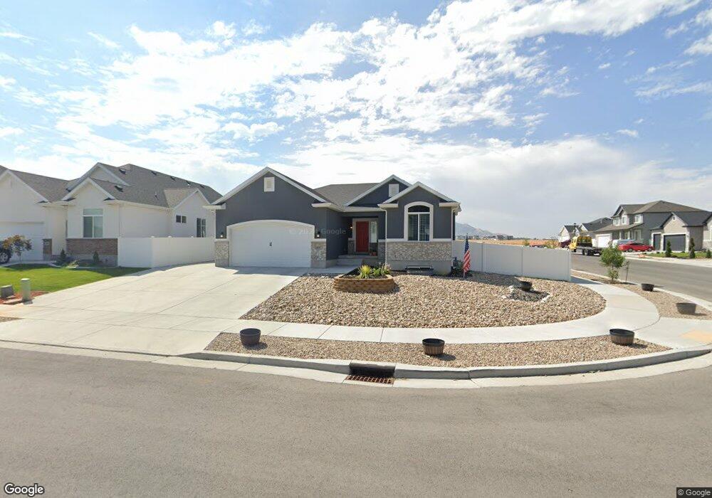
611 W 1960 N Tooele, UT 84074
Estimated Value: $497,000 - $554,000
3
Beds
2
Baths
2,851
Sq Ft
$180/Sq Ft
Est. Value
About This Home
This home is located at 611 W 1960 N, Tooele, UT 84074 and is currently estimated at $513,868, approximately $180 per square foot. 611 W 1960 N is a home located in Tooele County with nearby schools including Overlake Elementary School, Clarke N. Johnsen Junior High School, and Stansbury High School.
Ownership History
Date
Name
Owned For
Owner Type
Purchase Details
Closed on
Jun 20, 2024
Sold by
Romriell Dallen and Romriell Jacee
Bought by
Ellery Erek and Ellery Sydnee
Current Estimated Value
Home Financials for this Owner
Home Financials are based on the most recent Mortgage that was taken out on this home.
Original Mortgage
$490,000
Outstanding Balance
$483,399
Interest Rate
7.09%
Mortgage Type
VA
Estimated Equity
$30,469
Purchase Details
Closed on
Jul 30, 2020
Sold by
Romriell Dallen
Bought by
Romriell Dallen and Romriell Jacee
Home Financials for this Owner
Home Financials are based on the most recent Mortgage that was taken out on this home.
Original Mortgage
$299,281
Interest Rate
3.1%
Mortgage Type
New Conventional
Create a Home Valuation Report for This Property
The Home Valuation Report is an in-depth analysis detailing your home's value as well as a comparison with similar homes in the area
Home Values in the Area
Average Home Value in this Area
Purchase History
| Date | Buyer | Sale Price | Title Company |
|---|---|---|---|
| Ellery Erek | -- | Title One | |
| Romriell Dallen | -- | Meridian Title Company | |
| Romriell Dallen | -- | Meridian Title Company | |
| Perry Homes Utah Inc | -- | Meridian Title Company |
Source: Public Records
Mortgage History
| Date | Status | Borrower | Loan Amount |
|---|---|---|---|
| Open | Ellery Erek | $490,000 | |
| Previous Owner | Romriell Dallen | $299,281 |
Source: Public Records
Tax History Compared to Growth
Tax History
| Year | Tax Paid | Tax Assessment Tax Assessment Total Assessment is a certain percentage of the fair market value that is determined by local assessors to be the total taxable value of land and additions on the property. | Land | Improvement |
|---|---|---|---|---|
| 2025 | -- | $247,300 | $56,375 | $190,925 |
| 2024 | -- | $247,275 | $56,375 | $190,900 |
| 2023 | $2,824 | $264,319 | $75,165 | $189,154 |
| 2022 | $3,019 | $259,774 | $94,017 | $165,757 |
| 2021 | $2,412 | $173,557 | $21,381 | $152,176 |
| 2020 | $566 | $38,875 | $38,875 | $0 |
| 2019 | $0 | $0 | $0 | $0 |
Source: Public Records
Map
Nearby Homes
- 1989 N Mantle Way
- 1939 N Mantle Way
- 519 W 1960 N Unit 230
- 507 W 2030 N
- Franklin Plan at Compass Point
- Ash Plan at Compass Point
- Chapman Plan at Compass Point
- Kennedy Plan at Compass Point
- McKinley Plan at Compass Point
- Hickory Plan at Compass Point
- Spruce Pantry Plan at Compass Point
- Holly Plan at Compass Point
- Basswood Plan at Compass Point
- Merriwood Plan at Compass Point
- Hancock Plan at Compass Point
- Harrison Plan at Compass Point
- Cedar Plan at Compass Point
- Monroe Plan at Compass Point
- Mesquite Plan at Compass Point
- Washington Plan at Compass Point
- 603 W 1960 N Unit 222
- 608 W 1910 N
- 593 W 1960 N Unit 223
- 1955 Mantle Way
- 1988 N Mantle Way
- 602 W 1960 N
- 1929 N Mantle Way Unit 216
- 1967 N Weston Way
- 583 W 1960 N
- 583 W 1960 N Unit 224
- 592 W 1960 N
- 1909 N Weston Way Unit 217
- 1909 Mantle Way
- 1898 N Mantle Way
- 582 W 1960 N Unit 208
- 573 W 1960 N
- 1903 N Mantle Way
- 574 W 1910 N Unit 304
- 572 W 1960 N Unit 207
- 563 W 1960 N