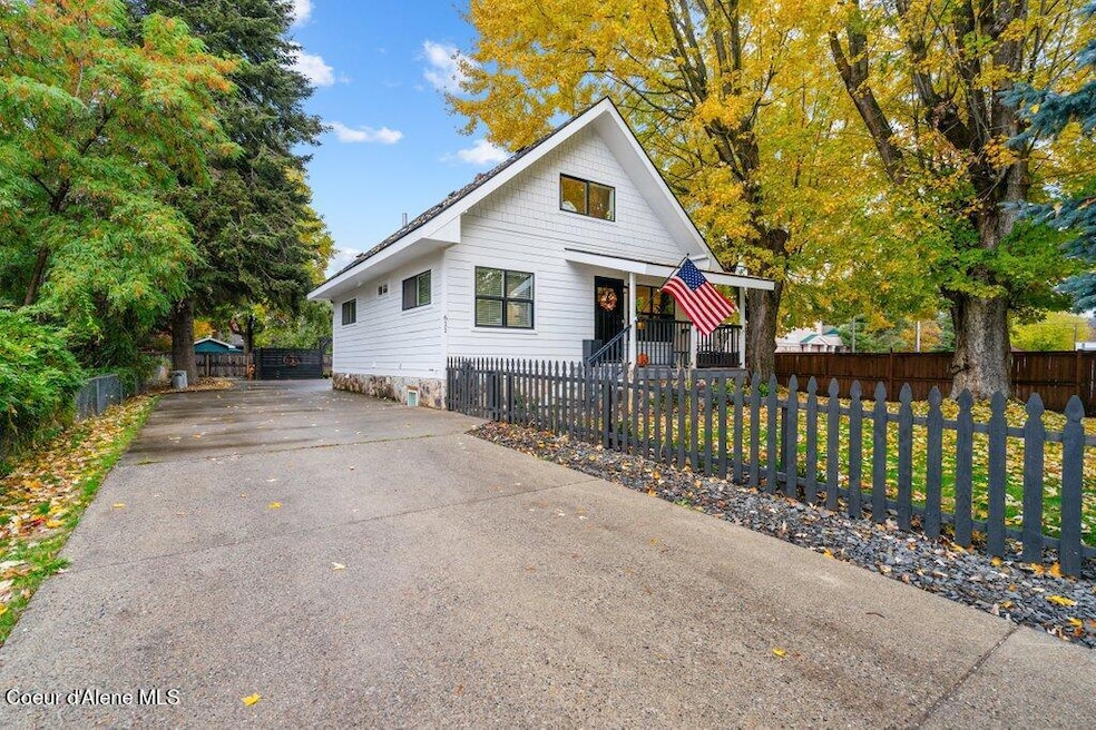
611 W Lacrosse Ave Coeur D Alene, ID 83814
Appleway-North 4th Street NeighborhoodEstimated payment $3,364/month
Highlights
- Greenhouse
- Traditional Architecture
- Lawn
- RV or Boat Parking
- Wood Flooring
- No HOA
About This Home
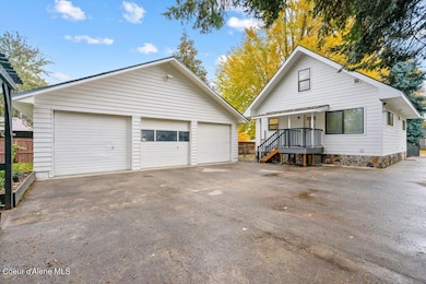
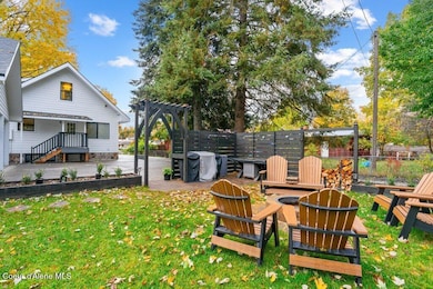
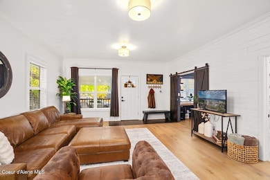
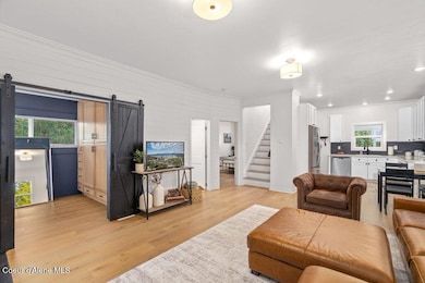
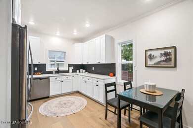
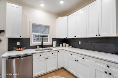
Fully Remodeled CDA Home Minutes to Downtown & Lake! Beautifully updated 4BD/3BA home in the heart of Coeur d'Alene, fully remodeled in 2022. Light and bright main level with modern finishes, open kitchen, and spacious living areas. Fully finished basement with second kitchen—perfect for multi-generational living or rental income opportunity. Enjoy the private, fully fenced yard featuring raised garden beds, greenhouse, and a cozy fire pit—ideal for outdoor entertaining. Rare 3-car attached garage provides ample parking and storage. Just minutes to downtown CDA, Lake Coeur d'Alene, parks, dining, and shopping! Modern updates, flexible living options, and an unbeatable location—this home is a must-see!
Home Details
Home Type
- Single Family
Est. Annual Taxes
- $2,737
Year Built
- Built in 1952 | Remodeled in 2022
Lot Details
- 10,454 Sq Ft Lot
- Property is Fully Fenced
- Landscaped
- Level Lot
- Lawn
- Garden
Home Design
- Traditional Architecture
- Concrete Foundation
- Frame Construction
- Shingle Roof
- Composition Roof
Interior Spaces
- 2,200 Sq Ft Home
- Multi-Level Property
- Wood Flooring
- Neighborhood Views
- Finished Basement
- Basement Fills Entire Space Under The House
Kitchen
- Breakfast Bar
- Gas Oven or Range
- Microwave
- Dishwasher
- Disposal
Bedrooms and Bathrooms
- 4 Bedrooms | 2 Main Level Bedrooms
- 3 Bathrooms
Laundry
- Electric Dryer
- Washer
Parking
- Attached Garage
- RV or Boat Parking
Outdoor Features
- Covered Patio or Porch
- Fire Pit
- Greenhouse
Utilities
- Forced Air Heating System
- Heating System Uses Natural Gas
- Gas Available
- Electric Water Heater
- High Speed Internet
- Internet Available
Community Details
- No Home Owners Association
Listing and Financial Details
- Assessor Parcel Number C3735018888V
Map
Home Values in the Area
Average Home Value in this Area
Tax History
| Year | Tax Paid | Tax Assessment Tax Assessment Total Assessment is a certain percentage of the fair market value that is determined by local assessors to be the total taxable value of land and additions on the property. | Land | Improvement |
|---|---|---|---|---|
| 2025 | $2,738 | $520,200 | $265,000 | $255,200 |
| 2024 | $2,738 | $498,800 | $240,000 | $258,800 |
| 2023 | $2,738 | $524,376 | $260,400 | $263,976 |
| 2022 | $2,593 | $494,910 | $280,000 | $214,910 |
| 2021 | $2,728 | $318,895 | $160,000 | $158,895 |
| 2020 | $2,139 | $242,238 | $128,829 | $113,409 |
| 2019 | $2,322 | $216,577 | $117,117 | $99,460 |
| 2018 | $2,173 | $180,600 | $90,090 | $90,510 |
| 2017 | $2,093 | $159,540 | $69,300 | $90,240 |
| 2016 | $2,077 | $150,160 | $63,000 | $87,160 |
| 2015 | $1,725 | $119,790 | $51,300 | $68,490 |
| 2013 | $1,681 | $106,620 | $42,750 | $63,870 |
Property History
| Date | Event | Price | List to Sale | Price per Sq Ft |
|---|---|---|---|---|
| 11/05/2025 11/05/25 | Pending | -- | -- | -- |
| 10/31/2025 10/31/25 | For Sale | $595,000 | -- | $270 / Sq Ft |
Purchase History
| Date | Type | Sale Price | Title Company |
|---|---|---|---|
| Warranty Deed | -- | Flying S Title And Escrow | |
| Interfamily Deed Transfer | -- | Kootenai County Title Co |
Mortgage History
| Date | Status | Loan Amount | Loan Type |
|---|---|---|---|
| Previous Owner | $261,750 | New Conventional |
Source: Coeur d'Alene Multiple Listing Service
MLS Number: 25-10690
APN: C3735018888V
Disclaimer: Certain information contained herein is derived from information provided by parties other than Homes.com. All information provided is deemed reliable, but is not guaranteed to be accurate and should be independently verified.
![]() IDX information is provided exclusively for personal, non-commercial use, and may not be used for any purpose other than to identify prospective properties consumers may be interested in purchasing.
IDX information is provided exclusively for personal, non-commercial use, and may not be used for any purpose other than to identify prospective properties consumers may be interested in purchasing.
Information is deemed reliable but not guaranteed.
- 1517 Lincoln Way
- 610 W Emma Ave
- 1819 N Nora St
- 1817 N Melrose St
- 1814 N Medina St
- 1024 W Mill Ave
- 530 W Harrison Ave
- 1841 N A St
- 1802 N A St
- 1215 N A St
- 1202 N A St
- 1108 N A St
- 1215 N 1st St
- 600 Hubbard Ave Unit 29
- 600 Hubbard Ave Unit 34
- 107 & 111 E Hattie Ave
- 105 E Miller Ave
- 1625 N 5th St
- 1508 N 5th St
- 1045 N 4th St
