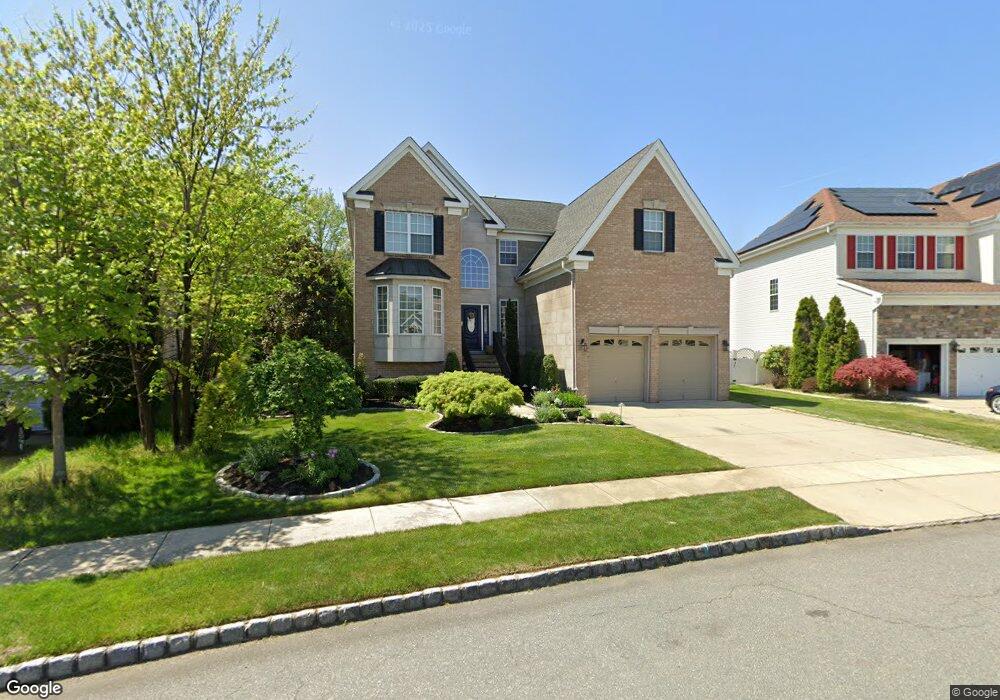
611 Worcester Dr West Deptford, NJ 08086
West Deptford Township NeighborhoodEstimated Value: $622,346 - $710,000
--
Bed
--
Bath
3,201
Sq Ft
$209/Sq Ft
Est. Value
About This Home
This home is located at 611 Worcester Dr, West Deptford, NJ 08086 and is currently estimated at $669,587, approximately $209 per square foot. 611 Worcester Dr is a home located in Gloucester County with nearby schools including Green-Fields Elementary School, Red Bank Elementary School, and Oakview Elementary School.
Ownership History
Date
Name
Owned For
Owner Type
Purchase Details
Closed on
May 22, 2006
Sold by
Inc-Nj D R Horton
Bought by
Corso Joseph R and Corso Pauline M
Current Estimated Value
Home Financials for this Owner
Home Financials are based on the most recent Mortgage that was taken out on this home.
Original Mortgage
$180,000
Outstanding Balance
$105,555
Interest Rate
6.62%
Mortgage Type
Purchase Money Mortgage
Estimated Equity
$564,032
Create a Home Valuation Report for This Property
The Home Valuation Report is an in-depth analysis detailing your home's value as well as a comparison with similar homes in the area
Home Values in the Area
Average Home Value in this Area
Purchase History
| Date | Buyer | Sale Price | Title Company |
|---|---|---|---|
| Corso Joseph R | $416,280 | -- |
Source: Public Records
Mortgage History
| Date | Status | Borrower | Loan Amount |
|---|---|---|---|
| Open | Corso Joseph R | $180,000 |
Source: Public Records
Tax History Compared to Growth
Tax History
| Year | Tax Paid | Tax Assessment Tax Assessment Total Assessment is a certain percentage of the fair market value that is determined by local assessors to be the total taxable value of land and additions on the property. | Land | Improvement |
|---|---|---|---|---|
| 2025 | $14,174 | $405,900 | $66,700 | $339,200 |
| 2024 | $13,991 | $405,900 | $66,700 | $339,200 |
| 2023 | $13,991 | $405,900 | $66,700 | $339,200 |
| 2022 | $13,926 | $405,900 | $66,700 | $339,200 |
| 2021 | $13,878 | $405,900 | $66,700 | $339,200 |
| 2020 | $13,845 | $405,900 | $66,700 | $339,200 |
| 2019 | $13,460 | $405,900 | $66,700 | $339,200 |
| 2018 | $13,094 | $405,900 | $66,700 | $339,200 |
| 2017 | $12,790 | $405,900 | $66,700 | $339,200 |
| 2016 | $12,433 | $405,900 | $66,700 | $339,200 |
| 2015 | $13,181 | $451,700 | $66,700 | $385,000 |
| 2014 | $12,526 | $451,700 | $66,700 | $385,000 |
Source: Public Records
Map
Nearby Homes
- 640 Worcester Dr
- 1091 Buckingham Dr Unit 45
- 863 Doncaster Dr
- 1066 Buckingham Dr
- 1012 Moore Rd Unit 6
- 12 Highbridge Ln Unit I2
- 125 Lionheart Ln Unit C125
- 87 Woodway Dr Unit 87
- 740 Carter Hill Dr
- 1220 Royal Ln
- 1102 Barnesdale Rd
- 1311 Barnesdale Rd
- 94 Aviary Rd
- 296 Ogden Station Rd
- 4 Saint Emilion Ct
- 14 Aviary Rd
- 1810 Fernwood Dr
- 97 Church St
- 90 Ginger Dr
- 247 Crown Point Rd