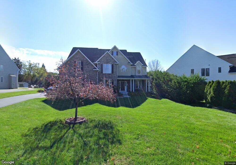
6111 Annie Dr Sykesville, MD 21784
Estimated Value: $748,334 - $911,000
--
Bed
4
Baths
3,754
Sq Ft
$219/Sq Ft
Est. Value
About This Home
This home is located at 6111 Annie Dr, Sykesville, MD 21784 and is currently estimated at $822,084, approximately $218 per square foot. 6111 Annie Dr is a home located in Carroll County with nearby schools including Freedom District Elementary School, Oklahoma Road Middle School, and Liberty High School.
Ownership History
Date
Name
Owned For
Owner Type
Purchase Details
Closed on
Feb 1, 2006
Sold by
Kimberly Homes Oklahoma Ridge Llc
Bought by
Zubar Victor W and Zubar Sweetie
Current Estimated Value
Home Financials for this Owner
Home Financials are based on the most recent Mortgage that was taken out on this home.
Original Mortgage
$483,076
Outstanding Balance
$268,720
Interest Rate
6%
Mortgage Type
Purchase Money Mortgage
Estimated Equity
$553,364
Create a Home Valuation Report for This Property
The Home Valuation Report is an in-depth analysis detailing your home's value as well as a comparison with similar homes in the area
Home Values in the Area
Average Home Value in this Area
Purchase History
| Date | Buyer | Sale Price | Title Company |
|---|---|---|---|
| Zubar Victor W | $727,076 | -- |
Source: Public Records
Mortgage History
| Date | Status | Borrower | Loan Amount |
|---|---|---|---|
| Open | Zubar Victor W | $483,076 |
Source: Public Records
Tax History Compared to Growth
Tax History
| Year | Tax Paid | Tax Assessment Tax Assessment Total Assessment is a certain percentage of the fair market value that is determined by local assessors to be the total taxable value of land and additions on the property. | Land | Improvement |
|---|---|---|---|---|
| 2025 | $7,057 | $626,500 | $0 | $0 |
| 2024 | $7,057 | $593,600 | $180,000 | $413,600 |
| 2023 | $7,057 | $593,600 | $180,000 | $413,600 |
| 2022 | $7,057 | $593,600 | $180,000 | $413,600 |
| 2021 | $15,091 | $602,300 | $160,000 | $442,300 |
| 2020 | $7,079 | $599,100 | $0 | $0 |
| 2019 | $7,103 | $595,900 | $0 | $0 |
| 2018 | $7,007 | $592,700 | $160,000 | $432,700 |
| 2017 | $6,811 | $575,233 | $0 | $0 |
| 2016 | -- | $557,767 | $0 | $0 |
| 2015 | -- | $540,300 | $0 | $0 |
| 2014 | -- | $540,300 | $0 | $0 |
Source: Public Records
Map
Nearby Homes
- Lot 2 Snowdens Run Rd
- 6223 E Hemlock Dr
- 1822 Cassandra Dr Unit 117
- 6467 Cornwall Dr Unit 56
- 5722 Banjo Dr
- 6515 Dundee Dr Unit 240
- 1900 Lennox Dr Unit 41
- 1900 Lennox Dr Unit 49
- 2016 Rudy Serra Dr Unit A
- 2016 Rudy Serra Dr Unit C
- 2023 Rudy Serra Dr Unit 2D
- 1909 Lennox Dr Unit 90
- 6210 Rolling View Dr
- 2010 Rudy Serra Dr Unit C
- 2003 Rudy Serra Dr Unit 1D
- 6505 Sunset Dr
- 6604 Monroe Ave
- 1809 Fallstaff Ct
- 2536 Arthur Ave
- 4017 Rudy Dr
- 6109 Annie Dr
- 6113 Annie Dr
- 6115 Annie Dr
- 2036 Red River Rd
- 2034 Red River Rd
- 2038 Red River Rd
- 2032 Red River Rd
- 6020 Monroe Ave
- 6158 Osage Ct
- 6156 Osage Ct
- 2040 Red River Rd
- 6024 Monroe Ave
- 2030 Red River Rd
- 2061 Annie Ct
- 6014 Monroe Ave
- 6010 Monroe Ave
- 2042 Red River Rd
- 6028 Monroe Ave
- 2028 Red River Rd
- 6002 Monroe Ave