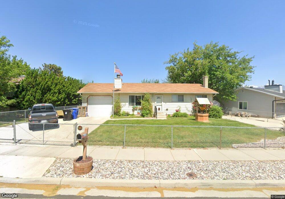
6117 Scorpio Dr Salt Lake City, UT 84118
Estimated Value: $425,971 - $464,000
4
Beds
2
Baths
1,092
Sq Ft
$412/Sq Ft
Est. Value
About This Home
This home is located at 6117 Scorpio Dr, Salt Lake City, UT 84118 and is currently estimated at $449,993, approximately $412 per square foot. 6117 Scorpio Dr is a home located in Salt Lake County with nearby schools including South Kearns Elementary School, Kearns Jr High School, and Kearns High School.
Ownership History
Date
Name
Owned For
Owner Type
Purchase Details
Closed on
Jul 21, 1994
Sold by
Gray Robert D and Gray Shawna
Bought by
Szarek Walter F and Szarek Melloney K
Current Estimated Value
Home Financials for this Owner
Home Financials are based on the most recent Mortgage that was taken out on this home.
Original Mortgage
$94,860
Interest Rate
8.5%
Mortgage Type
VA
Create a Home Valuation Report for This Property
The Home Valuation Report is an in-depth analysis detailing your home's value as well as a comparison with similar homes in the area
Home Values in the Area
Average Home Value in this Area
Purchase History
| Date | Buyer | Sale Price | Title Company |
|---|---|---|---|
| Szarek Walter F | -- | -- |
Source: Public Records
Mortgage History
| Date | Status | Borrower | Loan Amount |
|---|---|---|---|
| Closed | Szarek Walter F | $94,860 |
Source: Public Records
Tax History Compared to Growth
Tax History
| Year | Tax Paid | Tax Assessment Tax Assessment Total Assessment is a certain percentage of the fair market value that is determined by local assessors to be the total taxable value of land and additions on the property. | Land | Improvement |
|---|---|---|---|---|
| 2025 | $2,736 | $395,500 | $112,800 | $282,700 |
| 2024 | $2,736 | $378,300 | $106,600 | $271,700 |
| 2023 | $2,675 | $355,700 | $102,500 | $253,200 |
| 2022 | $2,475 | $338,200 | $100,400 | $237,800 |
| 2021 | $2,222 | $273,600 | $77,200 | $196,400 |
| 2020 | $2,079 | $239,500 | $77,200 | $162,300 |
| 2019 | $2,009 | $229,300 | $72,900 | $156,400 |
| 2018 | $1,916 | $211,200 | $72,900 | $138,300 |
| 2017 | $1,861 | $186,200 | $72,900 | $113,300 |
| 2016 | $1,878 | $170,600 | $72,900 | $97,700 |
| 2015 | $1,812 | $153,800 | $70,200 | $83,600 |
| 2014 | $1,587 | $147,400 | $68,000 | $79,400 |
Source: Public Records
Map
Nearby Homes
- 4230 W Stratus St
- 3978 W Marlis Cir
- 6073 S 4350 W
- 6330 S 4015 W
- 6377 Fairwind Dr
- 5836 S 4270 W
- 6033 S 4520 W
- 4468 W Tidwell St
- 3977 Rivendell Rd Unit A-B
- 4077 W 5740 S
- 4120 W 5740 S
- 4321 W 5740 S
- 6578 S 4165 W
- 6102 S 4590 W
- 4340 W 5740 S
- 4207 W 5655 S
- 4243 W 5655 S
- 4371 W 5700 S
- 4164 W Millsden Ln
- 4161 W 5615 S
- 6105 Scorpio Dr
- 6127 Scorpio Dr
- 6102 Aries Dr
- 6110 Aries Dr
- 6110 S Aries Dr
- 6095 S Scorpio Dr
- 6095 Scorpio Dr
- 6137 Scorpio Dr
- 6137 S Scorpio Dr
- 6116 Scorpio Dr
- 6124 Scorpio Dr
- 6106 S Scorpio Dr
- 6106 Scorpio Dr
- 6092 Aries Dr
- 6132 Scorpio Dr
- 6122 Aries Dr
- 6085 S Scorpio Dr
- 6085 Scorpio Dr
- 10700 S 4100 W Unit 220
- 10700 S 4100 W Unit 218