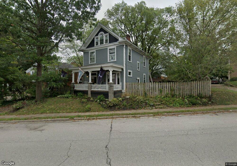
6119 Corbly Rd Cincinnati, OH 45230
Mount Washington NeighborhoodEstimated Value: $228,464 - $266,000
4
Beds
1
Bath
1,563
Sq Ft
$160/Sq Ft
Est. Value
About This Home
This home is located at 6119 Corbly Rd, Cincinnati, OH 45230 and is currently estimated at $250,366, approximately $160 per square foot. 6119 Corbly Rd is a home located in Hamilton County with nearby schools including Mt. Washington Elementary School, Clark Montessori High School, and Shroder High School.
Ownership History
Date
Name
Owned For
Owner Type
Purchase Details
Closed on
May 2, 2014
Sold by
Lorenz Heather N
Bought by
Lorenz Mark J
Current Estimated Value
Purchase Details
Closed on
Jul 21, 2000
Sold by
Barkley Judith G
Bought by
Lorenz Mark J and Lorenz Heather N
Home Financials for this Owner
Home Financials are based on the most recent Mortgage that was taken out on this home.
Original Mortgage
$92,000
Outstanding Balance
$31,225
Interest Rate
8.31%
Estimated Equity
$219,141
Create a Home Valuation Report for This Property
The Home Valuation Report is an in-depth analysis detailing your home's value as well as a comparison with similar homes in the area
Home Values in the Area
Average Home Value in this Area
Purchase History
| Date | Buyer | Sale Price | Title Company |
|---|---|---|---|
| Lorenz Mark J | -- | None Available | |
| Lorenz Mark J | $115,000 | -- |
Source: Public Records
Mortgage History
| Date | Status | Borrower | Loan Amount |
|---|---|---|---|
| Open | Lorenz Mark J | $92,000 |
Source: Public Records
Tax History
| Year | Tax Paid | Tax Assessment Tax Assessment Total Assessment is a certain percentage of the fair market value that is determined by local assessors to be the total taxable value of land and additions on the property. | Land | Improvement |
|---|---|---|---|---|
| 2025 | $3,688 | $59,262 | $10,395 | $48,867 |
| 2023 | $3,659 | $59,262 | $10,395 | $48,867 |
| 2022 | $2,815 | $40,775 | $8,778 | $31,997 |
| 2021 | $2,701 | $40,775 | $8,778 | $31,997 |
| 2020 | $2,777 | $40,775 | $8,778 | $31,997 |
| 2019 | $2,655 | $35,767 | $7,700 | $28,067 |
| 2018 | $2,659 | $35,767 | $7,700 | $28,067 |
| 2017 | $2,527 | $35,767 | $7,700 | $28,067 |
| 2016 | $2,673 | $37,310 | $7,700 | $29,610 |
| 2015 | $2,410 | $37,310 | $7,700 | $29,610 |
| 2014 | $2,427 | $37,310 | $7,700 | $29,610 |
| 2013 | $2,468 | $37,310 | $7,700 | $29,610 |
Source: Public Records
Map
Nearby Homes
- 6122 Corbly Rd
- 2111 Sutton Ave
- 2133 Ronaldson Ave
- 6253 Sturdy Ave
- 1229 Meadowbright Ln
- 1944 Rockland Ave
- 6050 Colter Ave
- 1486 Meadowbright Ln
- 6050 Bagdad Dr
- 5965 Wayside Ave
- 1741 Mears Ave
- 6029 Lockard Ave
- 6123 Cambridge Ave
- 2140 Trailwood Dr
- 6542 Rainbow Ln
- 2412 Findlater Ct
- 6601 Ripplewood Ln
- 1508 Beth Ln
- 1627 Alcor Terrace
- 1190 Linden Hill Ln
- 2119 Oxford Ave Unit 6
- 2123 Oxford Ave
- 2117 Oxford Ave Unit 5
- 2109 Oxford Ave
- 2125 Oxford Ave
- 2131 Oxford Ave
- 2113 Oxford Ave
- 2115 Oxford Ave
- 2121 Oxford Ave
- 2111 Oxford Ave
- 6120 Corbly Rd
- 6118 Corbly Rd
- 2110 Sutton Ave
- 6114 Corbly Rd
- 6127 Corbly Rd
- 2105 Oxford Ave
- 6110 Corbly Rd
- 2106 Sutton Ave
- 2102 Sutton Ave
- 2131 Beechmont Ave
Your Personal Tour Guide
Ask me questions while you tour the home.