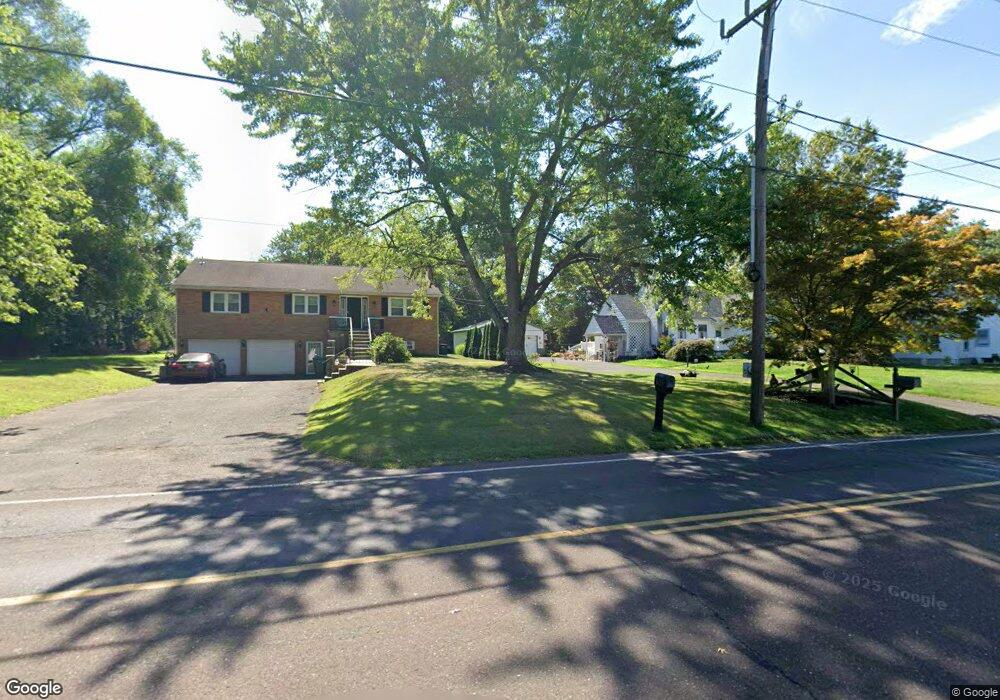
612 Cowpath Rd Hatfield, PA 19440
Estimated Value: $418,857 - $517,000
3
Beds
1
Bath
1,778
Sq Ft
$265/Sq Ft
Est. Value
About This Home
This home is located at 612 Cowpath Rd, Hatfield, PA 19440 and is currently estimated at $471,214, approximately $265 per square foot. 612 Cowpath Rd is a home located in Montgomery County with nearby schools including Oak Park El School, Pennfield Middle School, and North Penn Senior High School.
Ownership History
Date
Name
Owned For
Owner Type
Purchase Details
Closed on
Jan 22, 2013
Sold by
Haldeman Jean M and Krauss David A
Bought by
Haldeman Jean M
Current Estimated Value
Purchase Details
Closed on
Feb 24, 2012
Sold by
Haldeman Jean M
Bought by
Haldeman Jean M and Krauss David A
Purchase Details
Closed on
Jun 26, 2009
Sold by
Haldeman Jean and Haldeman George
Bought by
Haldeman Jean M
Home Financials for this Owner
Home Financials are based on the most recent Mortgage that was taken out on this home.
Original Mortgage
$130,000
Interest Rate
4.93%
Create a Home Valuation Report for This Property
The Home Valuation Report is an in-depth analysis detailing your home's value as well as a comparison with similar homes in the area
Home Values in the Area
Average Home Value in this Area
Purchase History
| Date | Buyer | Sale Price | Title Company |
|---|---|---|---|
| Haldeman Jean M | -- | None Available | |
| Haldeman Jean M | -- | None Available | |
| Haldeman Jean M | -- | None Available |
Source: Public Records
Mortgage History
| Date | Status | Borrower | Loan Amount |
|---|---|---|---|
| Closed | Haldeman Jean M | $130,000 |
Source: Public Records
Tax History
| Year | Tax Paid | Tax Assessment Tax Assessment Total Assessment is a certain percentage of the fair market value that is determined by local assessors to be the total taxable value of land and additions on the property. | Land | Improvement |
|---|---|---|---|---|
| 2025 | $5,160 | $128,880 | $56,470 | $72,410 |
| 2024 | $5,160 | $128,880 | $56,470 | $72,410 |
| 2023 | $4,938 | $128,880 | $56,470 | $72,410 |
| 2022 | $4,778 | $128,880 | $56,470 | $72,410 |
| 2021 | $4,642 | $128,880 | $56,470 | $72,410 |
| 2020 | $4,532 | $128,880 | $56,470 | $72,410 |
| 2019 | $4,457 | $128,880 | $56,470 | $72,410 |
Source: Public Records
Map
Nearby Homes
- 7 Fortuna Dr
- 2 Fortuna Dr
- 6 Fortuna Dr
- Lot 0 Fortuna Dr
- 2288 Rebecca Dr
- 1315 Deer Run Rd
- 1514 Maple Ave
- 2732 Valley Woods Rd
- 816 Kenilworth Ave
- 1943 Linden Ln
- 1714 Lydia Dr
- 737 Shaw Ave
- 000 Lenape Dr
- 1118 Emerald Ave
- 83 Bethlehem Pike Unit 1306- HAMILTON PLAN
- 83 Bethlehem Pike Unit 1405
- 83 Bethlehem Pike Unit 1111
- 83 Bethlehem Pike Unit 1106- MADISON PLAN
- 83 Bethlehem Pike Unit 1102- IVY FLOORPLAN
- 83 Bethlehem Pike Unit 1109 LEWIS FLOORPLAN
- 620 Cowpath Rd
- 606 Cowpath Rd
- 632 Cowpath Rd
- 615 Cowpath Rd
- 625 Cowpath Rd
- 540 Cowpath Rd
- 611 Cowpath Rd
- 703 Cowpath Rd
- 1978 Moyer Rd
- 607 Cowpath Rd
- 1974 Moyer Rd
- 660 Cowpath Rd
- 1931 Line Lexington Rd
- 1922 Line Lexington Rd
- 1720 Moyer Rd
- 1689 Forest Hills Dr
- 708 Cowpath Rd
- 1930 Line Lexington Rd
- 529 Cowpath Rd
- 526 Cowpath Rd
Your Personal Tour Guide
Ask me questions while you tour the home.