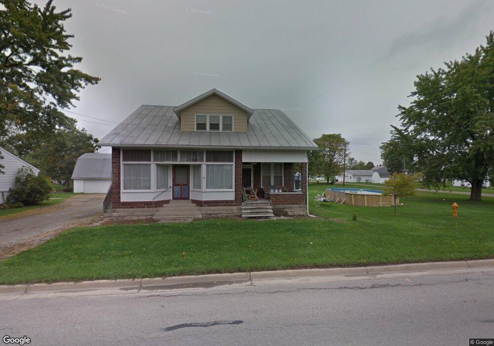
6120 Scofield Rd Maybee, MI 48159
Estimated Value: $249,704 - $437,000
3
Beds
3
Baths
2,400
Sq Ft
$126/Sq Ft
Est. Value
About This Home
This home is located at 6120 Scofield Rd, Maybee, MI 48159 and is currently estimated at $302,176, approximately $125 per square foot. 6120 Scofield Rd is a home located in Monroe County with nearby schools including Monroe High School, Holy Ghost Lutheran School, and St. Patrick Elementary School.
Ownership History
Date
Name
Owned For
Owner Type
Purchase Details
Closed on
Feb 28, 2012
Sold by
Maurer Nadine B and Liedel Herbert T
Bought by
Maurer Chad W and Maurer Christina L
Current Estimated Value
Purchase Details
Closed on
Dec 15, 2011
Sold by
Maurer Nadine B
Bought by
Maurer Nadine B and Liedel Herbert T
Create a Home Valuation Report for This Property
The Home Valuation Report is an in-depth analysis detailing your home's value as well as a comparison with similar homes in the area
Home Values in the Area
Average Home Value in this Area
Purchase History
| Date | Buyer | Sale Price | Title Company |
|---|---|---|---|
| Maurer Chad W | -- | -- | |
| Maurer Nadine B | -- | -- |
Source: Public Records
Tax History Compared to Growth
Tax History
| Year | Tax Paid | Tax Assessment Tax Assessment Total Assessment is a certain percentage of the fair market value that is determined by local assessors to be the total taxable value of land and additions on the property. | Land | Improvement |
|---|---|---|---|---|
| 2025 | $2,704 | $105,600 | $9,900 | $95,700 |
| 2024 | $726 | $91,500 | $0 | $0 |
| 2023 | $691 | $79,250 | $0 | $0 |
| 2022 | $2,427 | $79,250 | $0 | $0 |
| 2021 | $2,385 | $74,800 | $0 | $0 |
| 2020 | $2,388 | $65,500 | $0 | $0 |
| 2019 | $2,302 | $65,500 | $0 | $0 |
| 2018 | $2,295 | $68,100 | $0 | $0 |
| 2017 | $2,221 | $58,050 | $0 | $0 |
| 2016 | $2,225 | $58,050 | $0 | $0 |
| 2015 | $2,218 | $53,450 | $0 | $0 |
| 2014 | $2,218 | $53,450 | $0 | $0 |
| 2013 | $2,246 | $55,450 | $0 | $0 |
Source: Public Records
Map
Nearby Homes
- 5571 Zink Rd
- 9150 Doty Rd
- 9306 Raisin St
- 000 Ohara Rd
- 8785 Sams Dr Unit 8793
- 7767 Frederick St
- 8757- 8765 Sams
- 7974 Kreps Dr
- 4833 Stadler Rd
- 8650 Stone Rd
- 4402 Watson Rd
- 4625 Bluebush Rd
- 8844 Weldwood Dr
- 8655 Ida Maybee Rd
- 3009 Gruber Rd
- 9601 Exeter Rd
- 8778 Redwood Dr
- Parcel C Timbers Rd
- Parcel A Timbers Rd
- Parcel E Timbers Rd
- 6111 Scofield Rd
- 6124 Scofield Rd
- 6090 Scofield Rd
- 6141 Scofield Rd
- 6139 Summit St
- 6087 Scofield Rd
- 6155 Scofield Rd
- 6083 Summit St
- 10205 Main St
- 6073 Scofield Rd
- 6161 Scofield Rd
- 6161 Scofield Rd
- 10172 Jefferson St
- 10239 Main St
- 10166 Rice St
- 6106 Summit St
- 6128 Summit St
- 6070 Summit St
- 6057 Scofield Rd
- 10220 Main St