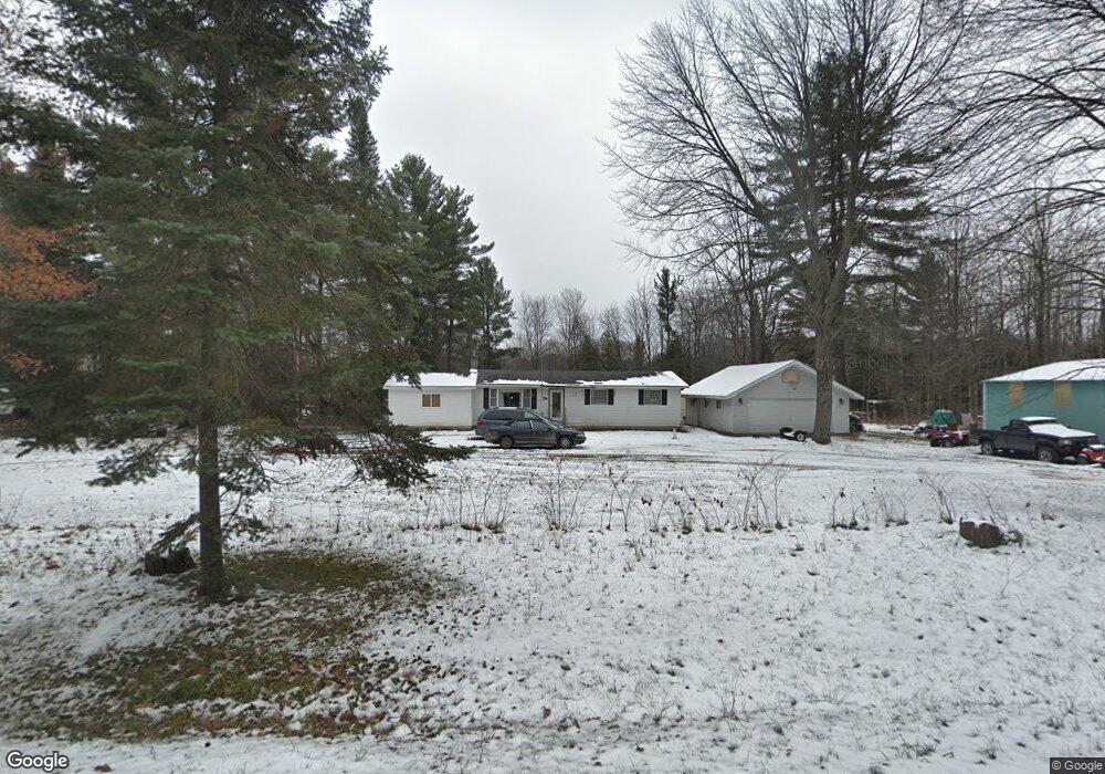
6121 W Geers Rd Mc Bain, MI 49657
Estimated Value: $245,000 - $274,000
--
Bed
--
Bath
--
Sq Ft
3
Acres
About This Home
This home is located at 6121 W Geers Rd, Mc Bain, MI 49657 and is currently estimated at $253,275. 6121 W Geers Rd is a home located in Missaukee County with nearby schools including McBain Elementary School, McBain Middle School, and McBain High School.
Ownership History
Date
Name
Owned For
Owner Type
Purchase Details
Closed on
Jun 15, 2012
Sold by
Secretary Of Veteran Affairs
Bought by
Knox Carrie
Current Estimated Value
Purchase Details
Closed on
Oct 18, 2011
Sold by
Wells Fargo Bank Na
Bought by
Secretary Of Veterans Affairs
Purchase Details
Closed on
Oct 14, 2011
Sold by
Bosscher James
Bought by
Wells Fargo Bank
Purchase Details
Closed on
Mar 22, 2011
Sold by
Elenbaas Samantha Mae and Poirier Samantha Mae
Bought by
Poirier Daniel James and Poirier Samantha Mae
Purchase Details
Closed on
Aug 31, 2007
Sold by
Powers Kevin A and Powers Ashley R
Bought by
Nasser Ronald E and Nasser Samantha M
Create a Home Valuation Report for This Property
The Home Valuation Report is an in-depth analysis detailing your home's value as well as a comparison with similar homes in the area
Home Values in the Area
Average Home Value in this Area
Purchase History
| Date | Buyer | Sale Price | Title Company |
|---|---|---|---|
| Knox Carrie | $25,000 | -- | |
| Secretary Of Veterans Affairs | -- | -- | |
| Wells Fargo Bank | $43,184 | -- | |
| Poirier Daniel James | -- | -- | |
| Nasser Ronald E | $80,000 | -- |
Source: Public Records
Tax History Compared to Growth
Tax History
| Year | Tax Paid | Tax Assessment Tax Assessment Total Assessment is a certain percentage of the fair market value that is determined by local assessors to be the total taxable value of land and additions on the property. | Land | Improvement |
|---|---|---|---|---|
| 2025 | $1,513 | $104,700 | $104,700 | $0 |
| 2024 | $587 | $86,100 | $86,100 | $0 |
| 2023 | $560 | $71,700 | $71,700 | $0 |
| 2022 | $533 | $63,300 | $63,300 | $0 |
| 2021 | $1,117 | $58,100 | $58,100 | $0 |
| 2020 | $512 | $53,700 | $53,700 | $0 |
| 2019 | $503 | $53,600 | $53,600 | $0 |
| 2018 | $1,095 | $52,900 | $0 | $0 |
| 2017 | $1,074 | $53,000 | $0 | $0 |
| 2016 | $866 | $45,200 | $0 | $0 |
| 2015 | -- | $39,500 | $0 | $0 |
| 2014 | -- | $37,000 | $0 | $0 |
Source: Public Records
Map
Nearby Homes
- 130 S Pine St
- 404 E Euclid St
- Lot #21 Hemlock St
- Lot #21 Hemlock St Unit 21
- Lot #20 Hemlock St
- Lot #20 Hemlock St Unit 20
- Lot #19 Hemlock St
- Lot #19 Hemlock St Unit 19
- 16 Lots S Hemlock St
- Lot #8 S Hemlock St Unit 8
- Lot #3 S Hemlock St Unit 3
- Lot #2 S Hemlock St Unit 2
- 16 Lots S Hemlock St Unit many
- Lot #18 Hemlock St
- Lot #18 Hemlock St Unit 18
- '0' Hemlock St
- 0 Hemlock St Unit 1911961
- Lot #11 Hemlock St
- Lot #11 Hemlock St Unit 11
- Lot #15 Hemlock St
- 6121 W Geers Rd
- 2433 W Geers Rd
- 9016 S Morey Rd
- 9200 S Morey Rd
- 9391 S Morey Rd
- 9391 S Morey Rd
- 6851 W Gerwoude Dr
- 6851 W Gerwoude Dr Unit 4
- 9438 S Morey Rd
- 8649 S Morey Rd
- 929 Gerwoude Dr
- 929 Gerwoude Dr Unit 4
- 9478 S Morey Rd
- 6600 Baker Dr E
- 220 S Sabina St
- 220 S Sabina St
- 220 S Sabina St
- 220 S Sabina St
- 8560 S Morey Rd
- 00 N Cherry St