Estimated Value: $759,000 - $823,000
3
Beds
2
Baths
3,684
Sq Ft
$214/Sq Ft
Est. Value
About This Home
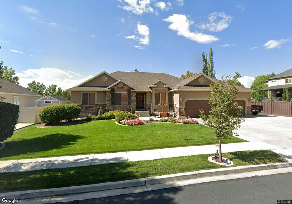
This home is located at 613 N 1580 E, Lehi, UT 84043 and is currently estimated at $789,560, approximately $214 per square foot. 613 N 1580 E is a home located in Utah County with nearby schools including Sego Lily Elementary School, Lehi Junior High School, and Skyridge High School.
Ownership History
Date
Name
Owned For
Owner Type
Purchase Details
Closed on
Feb 10, 2022
Sold by
Hill Gary T
Bought by
Hill Family Revocable Trust
Current Estimated Value
Purchase Details
Closed on
May 25, 2012
Sold by
Bazinet Jacques and Bazinet Marilyn K
Bought by
Hill Gary T and Hill Bernice K
Home Financials for this Owner
Home Financials are based on the most recent Mortgage that was taken out on this home.
Original Mortgage
$191,750
Interest Rate
3.86%
Mortgage Type
New Conventional
Purchase Details
Closed on
Aug 3, 2006
Sold by
Ivory Homes Ltd
Bought by
Bazinet Jacques and Bazinet Marilyn K
Home Financials for this Owner
Home Financials are based on the most recent Mortgage that was taken out on this home.
Original Mortgage
$240,000
Interest Rate
6.69%
Mortgage Type
New Conventional
Create a Home Valuation Report for This Property
The Home Valuation Report is an in-depth analysis detailing your home's value as well as a comparison with similar homes in the area
Home Values in the Area
Average Home Value in this Area
Purchase History
| Date | Buyer | Sale Price | Title Company |
|---|---|---|---|
| Hill Family Revocable Trust | -- | None Listed On Document | |
| Hill Gary T | -- | Empire Lans Title | |
| Bazinet Jacques | -- | Cottonwood Title | |
| Ivory Homes Ltd | -- | Cottonwood Title |
Source: Public Records
Mortgage History
| Date | Status | Borrower | Loan Amount |
|---|---|---|---|
| Previous Owner | Hill Gary T | $191,750 | |
| Previous Owner | Bazinet Jacques | $240,000 |
Source: Public Records
Tax History
| Year | Tax Paid | Tax Assessment Tax Assessment Total Assessment is a certain percentage of the fair market value that is determined by local assessors to be the total taxable value of land and additions on the property. | Land | Improvement |
|---|---|---|---|---|
| 2025 | $3,161 | $423,445 | -- | -- |
| 2024 | $3,161 | $369,875 | $0 | $0 |
| 2023 | $2,870 | $364,705 | $0 | $0 |
| 2022 | $3,175 | $391,105 | $0 | $0 |
| 2021 | $2,839 | $528,800 | $166,800 | $362,000 |
| 2020 | $2,677 | $492,700 | $154,400 | $338,300 |
| 2019 | $2,344 | $448,600 | $154,400 | $294,200 |
| 2018 | $2,294 | $415,000 | $136,400 | $278,600 |
| 2017 | $2,254 | $216,755 | $0 | $0 |
| 2016 | $2,189 | $195,305 | $0 | $0 |
| 2015 | $2,256 | $191,125 | $0 | $0 |
| 2014 | $1,919 | $161,590 | $0 | $0 |
Source: Public Records
Map
Nearby Homes
- 551 N 1520 E
- 499 N 1520 E
- 556 N 1440 E
- 822 N 860 W Unit 317
- 422 N 1322 E
- 808 N 860 W
- 3947 W 1000 N Unit 439
- 3959 W 1000 N
- 3995 W 1000 N
- 893 N 1580 E
- 822 W 800 St N Unit LOT319
- 764 W 880 North St Unit 308
- 1785 E 900 N
- 672 W 900 N
- 952 N 680 W
- 1635 E 1060 N
- 1175 E 900 N
- 1076 W State Rd Unit 204
- 524 N 900 E
- 484 N 950 W Unit 7
Your Personal Tour Guide
Ask me questions while you tour the home.