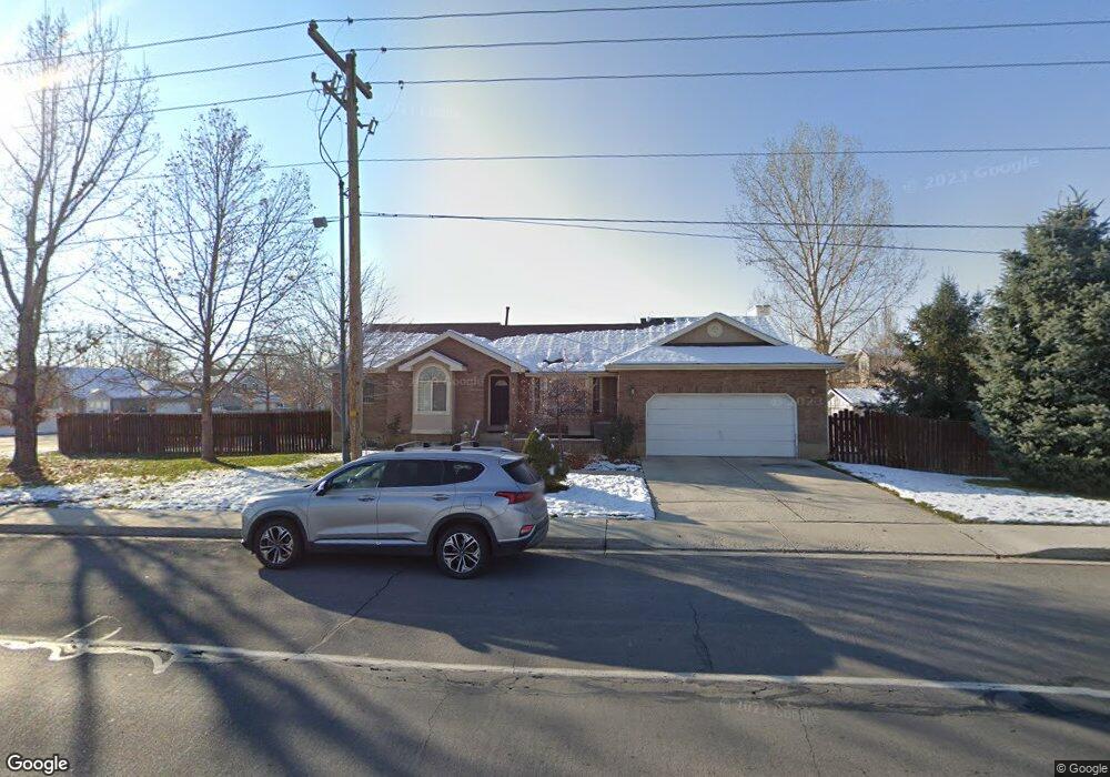
613 N 600 W Pleasant Grove, UT 84062
Estimated Value: $579,000 - $627,000
3
Beds
3
Baths
1,537
Sq Ft
$387/Sq Ft
Est. Value
About This Home
This home is located at 613 N 600 W, Pleasant Grove, UT 84062 and is currently estimated at $595,205, approximately $387 per square foot. 613 N 600 W is a home located in Utah County with nearby schools including Mount Mahogany School, Pleasant Grove Junior High School, and Pleasant Grove High School.
Ownership History
Date
Name
Owned For
Owner Type
Purchase Details
Closed on
Oct 27, 2016
Sold by
Mcpherson Bryan D
Bought by
Mcpherson Bryan and Mcpherson Melanie
Current Estimated Value
Purchase Details
Closed on
Aug 16, 2006
Sold by
Johnson Charles and Johnson Gaye
Bought by
Mcpherson Bryan D
Purchase Details
Closed on
Aug 7, 2006
Sold by
Baird Saundra L
Bought by
Johnson Charles and Johnson Gaye
Create a Home Valuation Report for This Property
The Home Valuation Report is an in-depth analysis detailing your home's value as well as a comparison with similar homes in the area
Home Values in the Area
Average Home Value in this Area
Purchase History
| Date | Buyer | Sale Price | Title Company |
|---|---|---|---|
| Mcpherson Bryan | -- | Provo Land Title Co | |
| Mcpherson Bryan D | -- | Inwest Title Services Inc | |
| Johnson Charles | -- | Provo Land Title Company |
Source: Public Records
Tax History Compared to Growth
Tax History
| Year | Tax Paid | Tax Assessment Tax Assessment Total Assessment is a certain percentage of the fair market value that is determined by local assessors to be the total taxable value of land and additions on the property. | Land | Improvement |
|---|---|---|---|---|
| 2025 | $2,389 | $311,355 | $213,700 | $352,400 |
| 2024 | $2,389 | $285,120 | $0 | $0 |
| 2023 | $2,322 | $283,690 | $0 | $0 |
| 2022 | $2,353 | $286,055 | $0 | $0 |
| 2021 | $2,083 | $385,500 | $143,100 | $242,400 |
| 2020 | $1,908 | $346,200 | $127,800 | $218,400 |
| 2019 | $1,824 | $342,300 | $123,900 | $218,400 |
| 2018 | $1,725 | $306,100 | $116,200 | $189,900 |
| 2017 | $1,716 | $162,085 | $0 | $0 |
| 2016 | $1,649 | $150,425 | $0 | $0 |
| 2015 | $1,637 | $141,405 | $0 | $0 |
| 2014 | $1,521 | $130,130 | $0 | $0 |
Source: Public Records
Map
Nearby Homes
- 685 W 1000 N
- 854 N 1010 W
- 1130 W State Rd
- 909 W 1180 N
- 1078 W 70 N
- 123 N Romney Ln Unit 103
- 1152 N 200 W
- 165 S Pleasant Blvd Unit 45
- 1249 W Cambria Dr Unit 101
- 150 N 1300 W
- 1051 N 600 W
- 1031 N 600 W
- 1041 N 600 W
- 1267 W 20 S
- 1443 W 1010 N
- 405 N 200 E
- 1096 N 1420 St W Unit 27
- 1429 W 110 N
- 1065 N 1420 W
- 278 S 740 W