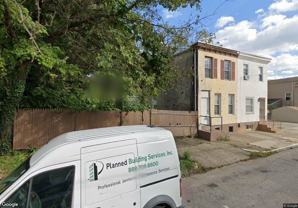
613 N Brooklyn St Philadelphia, PA 19104
Haverford North NeighborhoodEstimated Value: $404,073 - $547,000
3
Beds
1
Bath
4,926
Sq Ft
$92/Sq Ft
Est. Value
About This Home
This home is located at 613 N Brooklyn St, Philadelphia, PA 19104 and is currently estimated at $451,768, approximately $91 per square foot. 613 N Brooklyn St is a home located in Philadelphia County with nearby schools including Alain Locke School, West Philadelphia High School, and Belmont Charter Elementary School.
Ownership History
Date
Name
Owned For
Owner Type
Purchase Details
Closed on
Aug 15, 2025
Sold by
613 Brooklyn St Llc
Bought by
Aiv Quadplex Ii Llc
Current Estimated Value
Purchase Details
Closed on
Apr 26, 2023
Sold by
Bond Thomas
Bought by
613 Brooklyn St Llc
Purchase Details
Closed on
Feb 3, 1981
Bought by
Bond Thomas
Create a Home Valuation Report for This Property
The Home Valuation Report is an in-depth analysis detailing your home's value as well as a comparison with similar homes in the area
Home Values in the Area
Average Home Value in this Area
Purchase History
| Date | Buyer | Sale Price | Title Company |
|---|---|---|---|
| Aiv Quadplex Ii Llc | $426,000 | Eagles Abstract | |
| 613 Brooklyn St Llc | $203,000 | None Listed On Document | |
| Bond Thomas | $9,000 | -- |
Source: Public Records
Tax History Compared to Growth
Tax History
| Year | Tax Paid | Tax Assessment Tax Assessment Total Assessment is a certain percentage of the fair market value that is determined by local assessors to be the total taxable value of land and additions on the property. | Land | Improvement |
|---|---|---|---|---|
| 2026 | $4,598 | $364,700 | $72,940 | $291,760 |
| 2025 | $4,598 | $364,700 | $72,940 | $291,760 |
| 2024 | $4,598 | $364,700 | $72,940 | $291,760 |
| 2023 | $4,598 | $328,500 | $65,700 | $262,800 |
| 2022 | $4,598 | $328,500 | $65,700 | $262,800 |
| 2021 | $1,515 | $0 | $0 | $0 |
| 2020 | $1,515 | $0 | $0 | $0 |
| 2019 | $1,460 | $0 | $0 | $0 |
| 2018 | $1,460 | $0 | $0 | $0 |
| 2017 | $1,460 | $0 | $0 | $0 |
| 2016 | $1,460 | $0 | $0 | $0 |
| 2015 | $10,191 | $0 | $0 | $0 |
| 2014 | -- | $104,300 | $24,892 | $79,408 |
| 2012 | -- | $3,072 | $519 | $2,553 |
Source: Public Records
Map
Nearby Homes
- 4220 Wallace St
- 617 N Hutton St
- 629 N Hutton St
- 4231 Haverford Ave
- 638 Hutton St
- 627 Hutton St
- 619 Hutton St
- 636 Hutton St
- 4310 Wallace St
- 4303 Haverford Ave
- 518 N Holly St
- 318 20 Budd St
- 4130 42 Aspen St
- 4234 Aspen St
- 4207 Aspen St
- 4052 Lancaster Ave
- 508 N Budd St
- 661 Brooklyn St
- 644 Brooklyn St
- 770 Brooklyn St
- 611 N Brooklyn St
- 4217 Haverford Ave
- 4215 Haverford Ave
- 4213 Haverford Ave
- 4211 Haverford Ave Unit 2
- 4211 Haverford Ave
- 4219 Haverford Ave
- 4209 Haverford Ave
- 621 N Brooklyn St
- 614 N Brooklyn St
- 612 N Brooklyn St
- 4207 Haverford Ave
- 610 N Brooklyn St
- 608 N 42nd St
- 4221 Haverford Ave
- 608 N Brooklyn St
- 610 N 42nd St
- 612 N 42nd St
- 623 N Brooklyn St
- 616 N 42nd St