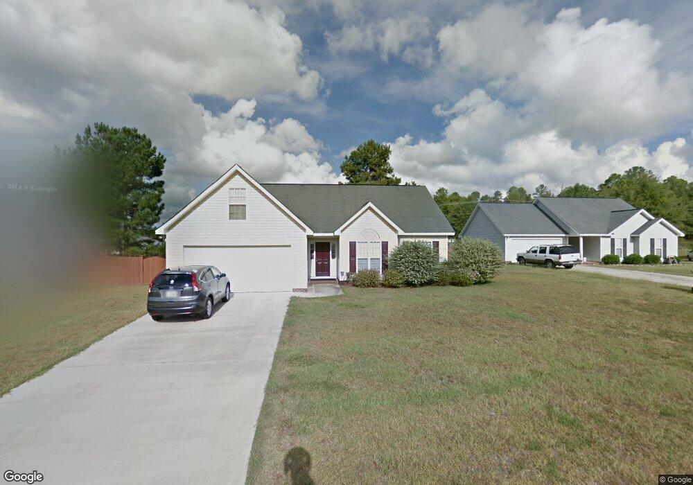
613 Newstock Dr Hopkins, SC 29061
Estimated Value: $225,000 - $248,000
3
Beds
2
Baths
1,602
Sq Ft
$148/Sq Ft
Est. Value
About This Home
This home is located at 613 Newstock Dr, Hopkins, SC 29061 and is currently estimated at $236,951, approximately $147 per square foot. 613 Newstock Dr is a home located in Richland County with nearby schools including Horrell Hill Elementary School, Southeast Middle School, and Lower Richland High School.
Ownership History
Date
Name
Owned For
Owner Type
Purchase Details
Closed on
Jan 4, 2022
Sold by
Milligan Dennis L and Lanese Carol M
Bought by
Sfr Jv 2 Property Llc
Current Estimated Value
Purchase Details
Closed on
Sep 8, 2005
Sold by
C & C Builders Of Columbia Inc
Bought by
Milligan Dennis L and Lanese Carol M
Home Financials for this Owner
Home Financials are based on the most recent Mortgage that was taken out on this home.
Original Mortgage
$121,710
Interest Rate
5.71%
Mortgage Type
Fannie Mae Freddie Mac
Create a Home Valuation Report for This Property
The Home Valuation Report is an in-depth analysis detailing your home's value as well as a comparison with similar homes in the area
Home Values in the Area
Average Home Value in this Area
Purchase History
| Date | Buyer | Sale Price | Title Company |
|---|---|---|---|
| Sfr Jv 2 Property Llc | $191,100 | None Available | |
| Milligan Dennis L | $134,234 | -- |
Source: Public Records
Mortgage History
| Date | Status | Borrower | Loan Amount |
|---|---|---|---|
| Previous Owner | Milligan Dennis L | $121,710 |
Source: Public Records
Tax History Compared to Growth
Tax History
| Year | Tax Paid | Tax Assessment Tax Assessment Total Assessment is a certain percentage of the fair market value that is determined by local assessors to be the total taxable value of land and additions on the property. | Land | Improvement |
|---|---|---|---|---|
| 2024 | $5,516 | $202,500 | $28,200 | $174,300 |
| 2023 | $5,516 | $4,444 | $0 | $0 |
| 2022 | $3,324 | $111,100 | $18,300 | $92,800 |
| 2021 | $3,318 | $6,670 | $0 | $0 |
| 2020 | $3,335 | $6,670 | $0 | $0 |
| 2019 | $3,314 | $6,670 | $0 | $0 |
| 2018 | $2,909 | $5,800 | $0 | $0 |
| 2017 | $2,828 | $5,800 | $0 | $0 |
| 2016 | $2,779 | $5,800 | $0 | $0 |
| 2015 | $2,741 | $5,800 | $0 | $0 |
| 2014 | $2,688 | $96,600 | $0 | $0 |
| 2013 | -- | $5,800 | $0 | $0 |
Source: Public Records
Map
Nearby Homes
- 856 White Fawn Dr
- 175 Rosecliff Cir
- 233 Rosebrook Dr
- 229 Keystone Dr
- 242 Keystone Dr
- 534 S Maney Ct
- 925 Farnsworth Dr
- W/S Trotter Rd
- 707 Common Widgeon Way
- 467 Hunters Crossing Dr
- 132 Pear Tree Cir
- 324 Bevington Brook Ln
- 410 Wisteria Walk Way
- 414 Wisteria Walk Way
- 300 Bevington Brook Ln
- 2904 S Partridge Cir
- 416 Wisteria Walk Way
- 341 Bevington Brook Ln
- 325 Bevington Brook Ln
- 321 Bevington Brook Ln
- 613 New Stock Dr
- 609 New Stock Dr
- 609 Newstock Dr
- 617 New Stock Dr
- 617 Newstock Dr
- 605 Newstock Dr
- 610 Newstock Dr
- 621 Newstock Dr
- 606 New Stock Dr
- 606 Newstock Dr
- 620 Newstock Dr
- 625 Newstock Dr
- 625 New Stock Dr
- 601 Newstock Dr
- 6 Rose Crest Place
- 2 Rose Crest Place
- 629 Newstock Dr
- 632 Newstock Dr
- 105 Myers Creek Dr
- 2 Rosecrest Place