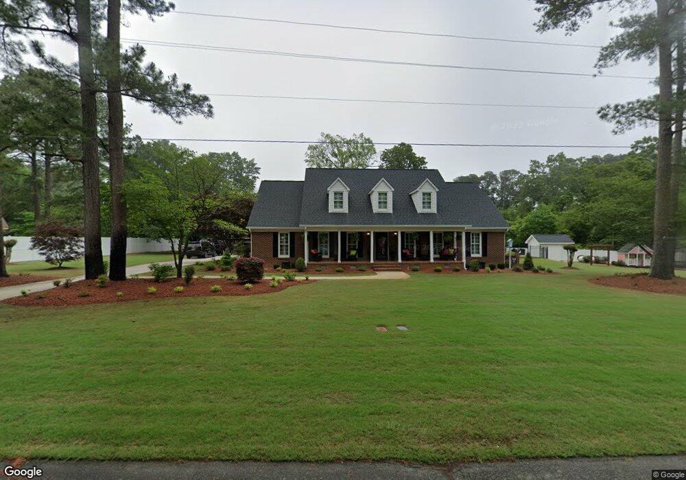
613 S Charles St La Grange, NC 28551
Estimated Value: $420,000 - $539,000
5
Beds
4
Baths
3,900
Sq Ft
$120/Sq Ft
Est. Value
About This Home
This home is located at 613 S Charles St, La Grange, NC 28551 and is currently estimated at $468,482, approximately $120 per square foot. 613 S Charles St is a home located in Lenoir County with nearby schools including La Grange Elementary School, E.B. Frink Middle School, and North Lenoir High School.
Ownership History
Date
Name
Owned For
Owner Type
Purchase Details
Closed on
Dec 20, 2018
Sold by
Community Baptist Church
Bought by
Williams Michael T and Riley-Williams Robin
Current Estimated Value
Purchase Details
Closed on
Feb 27, 2014
Sold by
Letchworth David A and Letchworth Tina N
Bought by
Williams Michael Todd and Mooring Robin Riley
Home Financials for this Owner
Home Financials are based on the most recent Mortgage that was taken out on this home.
Original Mortgage
$218,500
Interest Rate
4.43%
Mortgage Type
New Conventional
Create a Home Valuation Report for This Property
The Home Valuation Report is an in-depth analysis detailing your home's value as well as a comparison with similar homes in the area
Home Values in the Area
Average Home Value in this Area
Purchase History
| Date | Buyer | Sale Price | Title Company |
|---|---|---|---|
| Williams Michael T | $3,000 | -- | |
| Williams Michael Todd | $230,000 | None Available |
Source: Public Records
Mortgage History
| Date | Status | Borrower | Loan Amount |
|---|---|---|---|
| Previous Owner | Williams Michael Todd | $218,500 |
Source: Public Records
Tax History Compared to Growth
Tax History
| Year | Tax Paid | Tax Assessment Tax Assessment Total Assessment is a certain percentage of the fair market value that is determined by local assessors to be the total taxable value of land and additions on the property. | Land | Improvement |
|---|---|---|---|---|
| 2025 | $5,477 | $545,838 | $38,364 | $507,474 |
| 2024 | $3,682 | $267,426 | $18,750 | $248,676 |
| 2023 | $3,682 | $267,426 | $18,750 | $248,676 |
| 2022 | $3,682 | $267,426 | $18,750 | $248,676 |
| 2021 | $3,682 | $267,426 | $18,750 | $248,676 |
| 2020 | $3,682 | $267,426 | $18,750 | $248,676 |
| 2019 | $3,682 | $267,426 | $18,750 | $248,676 |
| 2018 | $3,165 | $232,362 | $16,500 | $215,862 |
| 2017 | $3,176 | $232,362 | $16,500 | $215,862 |
| 2014 | $3,427 | $266,714 | $16,500 | $250,214 |
| 2013 | -- | $266,714 | $16,500 | $250,214 |
| 2011 | -- | $266,714 | $16,500 | $250,214 |
Source: Public Records
Map
Nearby Homes
- 408 Lake Pines Dr
- 105 Circle Dr
- 302 S Caswell St
- 614 S Caswell St
- 219 Wood St
- 202 E Washington St
- 217 Wood St
- 210 Wood St
- 208 Wood St
- 201 Wood St
- 204 Wood St
- 205 Wood St
- 206 Wood St
- 202 Wood St
- 216 W Railroad St
- 110 W Railroad St
- 128 E Railroad St
- Belhaven Plan at Blair Ridge
- Hayden Plan at Blair Ridge
- Cali Plan at Blair Ridge
- 613 Charles St S
- 613 Charles St
- 611 S Charles St
- 609 S Charles St
- 101 Club Rd
- 102 Club Rd
- 104 Club Rd
- 607 S Charles St
- 618 S Charles St
- 605 S Charles St
- 113 Circle Dr
- 106 Club Rd
- 314 Lake Pines Dr
- 603 S Charles St
- 107 Club Rd
- 312 Lake Pines Dr
- 616 S Charles St
- 402 Lake Pines Dr
- 108 Club Rd
- 114 Circle Dr