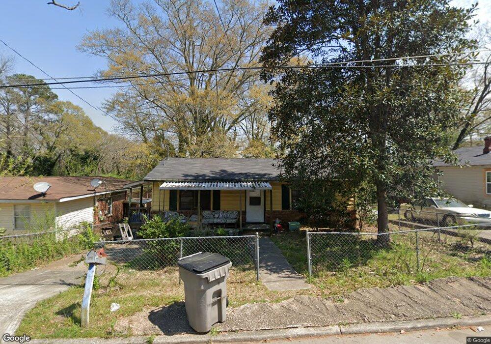
613 Snelson St Lagrange, GA 30241
Estimated Value: $59,033 - $124,000
2
Beds
1
Bath
864
Sq Ft
$94/Sq Ft
Est. Value
About This Home
This home is located at 613 Snelson St, Lagrange, GA 30241 and is currently estimated at $81,508, approximately $94 per square foot. 613 Snelson St is a home located in Troup County with nearby schools including Hollis Hand Elementary School, Franklin Forest Elementary School, and Ethel W. Kight Elementary School.
Ownership History
Date
Name
Owned For
Owner Type
Purchase Details
Closed on
Jul 25, 2003
Sold by
Citifinacial
Bought by
Edelson Stephen L
Current Estimated Value
Purchase Details
Closed on
Jun 3, 2003
Sold by
Bailey Willie James
Bought by
Citifinacial
Purchase Details
Closed on
Jun 6, 1984
Sold by
Gloria Willie J and Gloria Bailey
Bought by
Bailey Willie James
Purchase Details
Closed on
Aug 22, 1978
Sold by
Bobby Lee Jones
Bought by
Gloria Willie J and Gloria Bailey
Purchase Details
Closed on
Jan 1, 1966
Bought by
Bobby Lee Jones
Purchase Details
Closed on
Jan 1, 1965
Sold by
Bartley J F
Create a Home Valuation Report for This Property
The Home Valuation Report is an in-depth analysis detailing your home's value as well as a comparison with similar homes in the area
Purchase History
| Date | Buyer | Sale Price | Title Company |
|---|---|---|---|
| Edelson Stephen L | $15,000 | -- | |
| Citifinacial | $30,100 | -- | |
| Bailey Willie James | -- | -- | |
| Gloria Willie J | $15,000 | -- | |
| Bobby Lee Jones | -- | -- | |
| -- | -- | -- |
Source: Public Records
Tax History
| Year | Tax Paid | Tax Assessment Tax Assessment Total Assessment is a certain percentage of the fair market value that is determined by local assessors to be the total taxable value of land and additions on the property. | Land | Improvement |
|---|---|---|---|---|
| 2025 | $432 | $15,840 | $3,080 | $12,760 |
| 2024 | $264 | $9,680 | $3,080 | $6,600 |
| 2023 | $244 | $8,960 | $3,080 | $5,880 |
| 2022 | $240 | $8,600 | $3,080 | $5,520 |
| 2021 | $164 | $5,440 | $1,840 | $3,600 |
| 2020 | $185 | $5,440 | $1,840 | $3,600 |
| 2019 | $152 | $5,030 | $1,350 | $3,680 |
| 2018 | $152 | $5,030 | $1,350 | $3,680 |
| 2017 | $152 | $5,030 | $1,350 | $3,680 |
| 2016 | $165 | $5,477 | $1,350 | $4,127 |
| 2015 | $167 | $5,526 | $1,399 | $4,127 |
| 2014 | $167 | $5,526 | $1,399 | $4,127 |
| 2013 | -- | $6,940 | $1,865 | $5,075 |
Source: Public Records
Map
Nearby Homes
- 615 Snelson St
- 609 Snelson St
- 617 Snelson St
- 612 Snelson St Unit S A & B
- 612 Snelson St
- 512 Burr St
- 603 Snelson St
- 608 Snelson St
- 601 Snelson St
- 314 Mccall St
- 514 Burr St
- 405 Mccall St
- 599 Snelson St
- 0 Mccall St Unit 8548795
- 0 Mccall St Unit 8548785
- 313 Mccall St
- 310 Mccall St
- 508 Burr St
- 205 Carver St
- 522 Daniel St
Your Personal Tour Guide
Ask me questions while you tour the home.