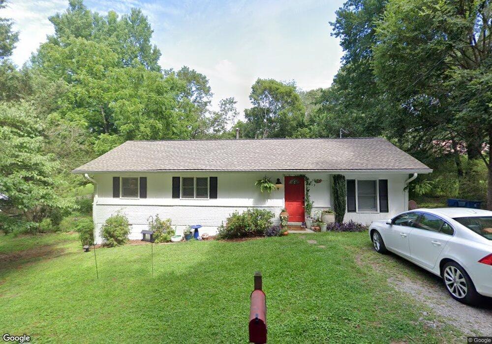
613 White St Suwanee, GA 30024
Estimated Value: $336,000 - $533,000
3
Beds
1
Bath
1,128
Sq Ft
$353/Sq Ft
Est. Value
About This Home
This home is located at 613 White St, Suwanee, GA 30024 and is currently estimated at $397,948, approximately $352 per square foot. 613 White St is a home located in Gwinnett County with nearby schools including Roberts Elementary School, North Gwinnett Middle School, and North Gwinnett High School.
Ownership History
Date
Name
Owned For
Owner Type
Purchase Details
Closed on
Mar 30, 2004
Sold by
Baker Darrell
Bought by
Bitting Sean C
Current Estimated Value
Home Financials for this Owner
Home Financials are based on the most recent Mortgage that was taken out on this home.
Original Mortgage
$99,200
Outstanding Balance
$17,947
Interest Rate
3.25%
Mortgage Type
New Conventional
Estimated Equity
$380,001
Purchase Details
Closed on
Jan 27, 2003
Sold by
Nolan William H and Nolan Diane S
Bought by
Baker Darrell
Home Financials for this Owner
Home Financials are based on the most recent Mortgage that was taken out on this home.
Original Mortgage
$95,000
Interest Rate
8.25%
Mortgage Type
New Conventional
Create a Home Valuation Report for This Property
The Home Valuation Report is an in-depth analysis detailing your home's value as well as a comparison with similar homes in the area
Home Values in the Area
Average Home Value in this Area
Purchase History
| Date | Buyer | Sale Price | Title Company |
|---|---|---|---|
| Bitting Sean C | $124,000 | -- | |
| Baker Darrell | -- | -- |
Source: Public Records
Mortgage History
| Date | Status | Borrower | Loan Amount |
|---|---|---|---|
| Open | Bitting Sean C | $99,200 | |
| Previous Owner | Baker Darrell | $95,000 |
Source: Public Records
Tax History Compared to Growth
Tax History
| Year | Tax Paid | Tax Assessment Tax Assessment Total Assessment is a certain percentage of the fair market value that is determined by local assessors to be the total taxable value of land and additions on the property. | Land | Improvement |
|---|---|---|---|---|
| 2025 | $2,349 | $74,320 | $28,000 | $46,320 |
| 2024 | $2,378 | $74,320 | $28,000 | $46,320 |
| 2023 | $2,378 | $74,320 | $28,000 | $46,320 |
| 2022 | $362 | $55,320 | $15,600 | $39,720 |
| 2021 | $273 | $55,320 | $15,600 | $39,720 |
| 2020 | $2,101 | $55,320 | $15,600 | $39,720 |
| 2019 | $1,624 | $49,040 | $13,200 | $35,840 |
| 2018 | $1,624 | $49,040 | $13,200 | $35,840 |
| 2016 | $1,622 | $49,040 | $13,200 | $35,840 |
| 2015 | $1,644 | $49,040 | $13,200 | $35,840 |
| 2014 | $1,530 | $45,360 | $18,800 | $26,560 |
Source: Public Records
Map
Nearby Homes
- The Murray Plan at Old Town Suwanee
- The Telfair Plan at Old Town Suwanee
- 0 Mary Lou St Unit 7445497
- 0 Mary Lou St Unit 10365827
- 3880 Brushy Creek Way
- 822 Urban Grange Way
- 645 Stonepark Ln
- 3655 Belle Fields Crossing
- 3615 Belle Fields Crossing
- 3625 Belle Fields Crossing
- 3675 Belle Fields Crossing
- 3685 Belle Fields Crossing
- 3645 Belle Fields Crossing
- 3635 Belle Fields Crossing
- Burton Plan at Echo Park
- Sinclair Plan at Echo Park
- Flint Plan at Echo Park
- 911 Echo Park Dr
- 923 Echo Park Dr
- 633 White St
- 593 White St
- 653 White St
- 801 White St
- 582 White St
- 3948 Russell St
- 652 White St
- 677 Main St
- 3939 Russell St
- 0 Russell St NW
- 3949 Russell St
- 662 White St
- 561 Buford Hwy
- 3888 Russell St
- 3660 Clairborne Farm
- 3635 Clairborne Farm
- 564 Scales Rd
- 3981 Scales St
- 641 Highway 23 NW
- 680 Jackson St