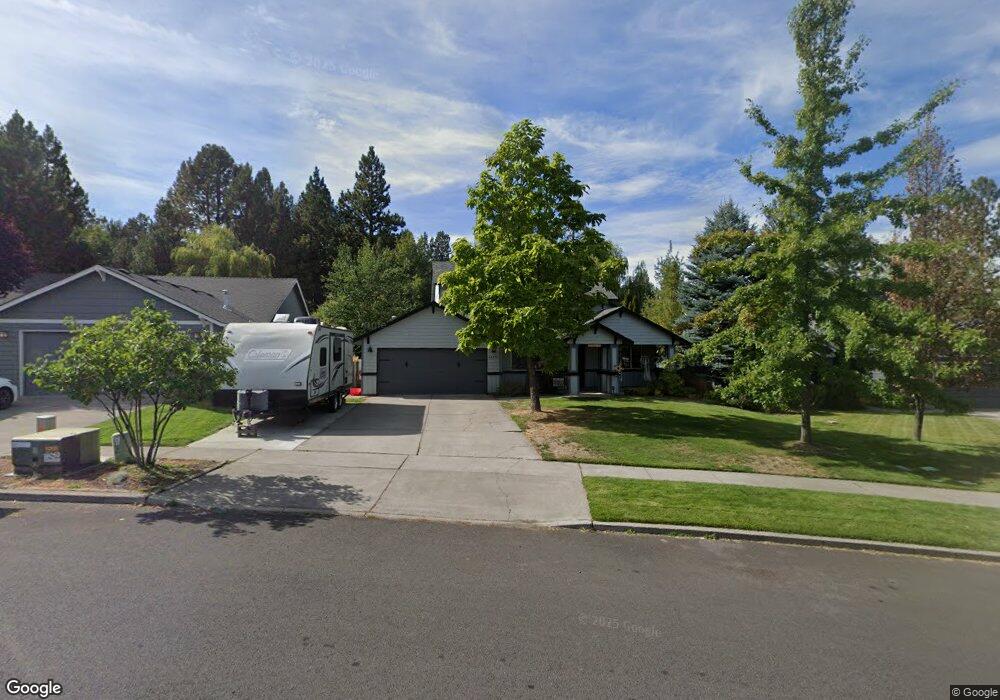
61375 Rock Bluff Ln Bend, OR 97702
Southwest Bend NeighborhoodEstimated Value: $804,000 - $850,412
About This Home
This home is located at 61375 Rock Bluff Ln, Bend, OR 97702 and is currently estimated at $823,853, approximately $373 per square foot. 61375 Rock Bluff Ln is a home located in Deschutes County with nearby schools including Pine Ridge Elementary School, Cascade Middle School, and Bend Senior High School.
Ownership History
We collect this data history from publicly available records. To have your information removed, we recommend requesting removal directly through your county’s website.
Purchase Details
Home Financials for this Owner
Home Financials are based on the most recent Mortgage that was taken out on this home.Home Values in the Area
Average Home Value in this Area
Purchase History
We collect this data history from publicly available records. To have your information removed, we recommend requesting removal directly through your county’s website.
| Date | Buyer | Sale Price | Title Company |
|---|---|---|---|
| $425,000 | Western Title & Escrow Co |
Mortgage History
We collect this data history from publicly available records. To have your information removed, we recommend requesting removal directly through your county’s website.
| Date | Status | Borrower | Loan Amount |
|---|---|---|---|
| Open | $340,000 |
Tax History
We collect this data history from publicly available records. To have your information removed, we recommend requesting removal directly through your county’s website.
| Year | Tax Paid | Tax Assessment Tax Assessment Total Assessment is a certain percentage of the fair market value that is determined by local assessors to be the total taxable value of land and additions on the property. | Land | Improvement |
|---|---|---|---|---|
| 2025 | $5,124 | $303,240 | ||
| 2024 | $4,929 | $294,410 | ||
| 2023 | $4,570 | $285,840 | $0 | $0 |
| 2022 | $4,263 | $269,440 | $0 | $0 |
| 2021 | $4,270 | $261,600 | $0 | $0 |
| 2020 | $4,051 | $261,600 | $0 | $0 |
| 2019 | $3,938 | $253,990 | $0 | $0 |
| 2018 | $3,827 | $246,600 | $0 | $0 |
| 2017 | $3,781 | $239,420 | $0 | $0 |
| 2016 | $3,609 | $232,450 | $0 | $0 |
| 2015 | $3,511 | $225,680 | $0 | $0 |
| 2014 | $3,409 | $219,110 | $0 | $0 |
Map
- 19870 Powers Rd
- 19951 Cliffrose Dr
- 61289 Bronze Meadow Ln
- 61285 Bronze Meadow Ln
- 61379 Sally Ln
- 20016 Mount Hope Ln
- 20085 Sally Ct
- 61274 Columbine Ln
- 61521 Sunny Breeze Ln
- 20090 Mount Faith Place
- 19985 Voltera Place
- 20000 Sorrento Place
- 61302 Huckleberry Place
- 61216 Brittle Bush St
- 61390 Merriewood Ct
- 19717 Mt Bachelor Dr Unit 330E
- 19717 Mount Bachelor Dr Unit 617
- 19717 SW Mount Bachelor Dr Unit 426
- 19717 SW Mount Bachelor Dr Unit 134
- 19717 SW Mount Bachelor Dr Unit 254
- 61379 Rock Bluff Ln
- 61371 Rock Bluff Ln
- 19936 Powers Rd
- 61383 Rock Bluff Ln
- 61367 Rock Bluff Ln
- 61374 Rock Bluff Ln
- 61370 Rock Bluff Ln
- 61387 Rock Bluff Ln
- 19930 Powers Rd
- 19931 Powers Rd
- 61386 Rock Bluff Ln
- 19955 Powers Rd
- 61363 Rock Bluff Ln
- 61391 Rock Bluff Ln
- 19924 Powers Rd
- 19966 Powers Rd
- 61390 Rock Bluff Ln
- 19961 Powers Rd
- 61395 Rock Bluff Ln
- 19925 Powers Rd
Ask me questions while you tour the home.