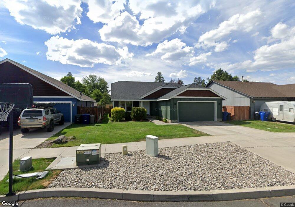
61383 Kobe St Bend, OR 97702
Old Farm District NeighborhoodEstimated Value: $521,638 - $592,000
3
Beds
2
Baths
1,572
Sq Ft
$353/Sq Ft
Est. Value
About This Home
This home is located at 61383 Kobe St, Bend, OR 97702 and is currently estimated at $555,660, approximately $353 per square foot. 61383 Kobe St is a home located in Deschutes County with nearby schools including Silver Rail Elementary School, High Desert Middle School, and Bend Senior High School.
Ownership History
Date
Name
Owned For
Owner Type
Purchase Details
Closed on
Apr 1, 2016
Sold by
Harms Susan
Bought by
Darryl L & Amy R Harms Family Revocable
Current Estimated Value
Purchase Details
Closed on
Dec 13, 2013
Sold by
Harms Susan
Bought by
Harms Susan and Susan E Harms Revocable Trust
Purchase Details
Closed on
Dec 29, 2005
Sold by
Harms Jeanett G
Bought by
Harms Jeanett G and Harms Family Trust
Purchase Details
Closed on
Oct 26, 2004
Sold by
Ball Bryan M
Bought by
Harms Jeanett and The Harms Family Trust
Create a Home Valuation Report for This Property
The Home Valuation Report is an in-depth analysis detailing your home's value as well as a comparison with similar homes in the area
Home Values in the Area
Average Home Value in this Area
Purchase History
| Date | Buyer | Sale Price | Title Company |
|---|---|---|---|
| Darryl L & Amy R Harms Family Revocable | $200,000 | None Available | |
| Harms Susan | -- | None Available | |
| Harms Jeanett G | -- | None Available | |
| Harms Jeanett | $184,069 | Western Title & Escrow Co |
Source: Public Records
Tax History
| Year | Tax Paid | Tax Assessment Tax Assessment Total Assessment is a certain percentage of the fair market value that is determined by local assessors to be the total taxable value of land and additions on the property. | Land | Improvement |
|---|---|---|---|---|
| 2025 | $3,594 | $212,720 | -- | -- |
| 2024 | $3,458 | $206,530 | -- | -- |
| 2023 | $3,206 | $200,520 | $0 | $0 |
| 2022 | $2,991 | $189,010 | $0 | $0 |
| 2021 | $2,995 | $183,510 | $0 | $0 |
| 2020 | $2,842 | $183,510 | $0 | $0 |
| 2019 | $2,763 | $178,170 | $0 | $0 |
| 2018 | $2,685 | $172,990 | $0 | $0 |
| 2017 | $2,606 | $167,960 | $0 | $0 |
| 2016 | $2,485 | $163,070 | $0 | $0 |
| 2015 | $2,417 | $158,330 | $0 | $0 |
| 2014 | $2,345 | $153,720 | $0 | $0 |
Source: Public Records
Map
Nearby Homes
- 61425 SE Daybreak Ct Unit Lot 6
- 61407 Kobe St
- 61429 SE Daybreak Ct Unit Lot 7
- 61405 SE Daybreak Ct
- 61433 SE Daybreak Ct Unit Lot 8
- 61409 SE Daybreak Ct Unit Lot 2
- 61441 SE Daybreak Ct Unit Lot 10
- 61437 SE Daybreak Ct Unit Lot 9
- 20609 SE Gemstone Ave Unit 131
- 20608 Rolen Ave
- 20594 SE Slate Ave
- 61346 Whitetail St
- 20606 SE Slate Ave
- 20599 Kira Dr Unit 382
- 20560 Kira Dr Unit 371
- 20600 Kira Dr Unit 362
- 61364 SE Matthew St
- 20632 Kira Dr
- 20580 Klahani Dr
- 20456 Brentwood Ave
- 61387 Kobe St
- 61379 Kobe St
- 61375 Kobe St
- 61391 Kobe St
- 61388 Franke Ln
- 61382 Franke Ln
- 20596 Dylan Loop
- 61371 Kobe St
- 61394 Franke Ln
- 61390 Kobe St
- 61376 Franke Ln
- 20510 Peak Ave
- 61367 Kobe St
- 20592 Dylan Loop
- 20593 Dylan Loop
- 20514 Peak Ave
- 61395 Kobe St Unit Lot 143
- 61471 SE Kobe St Unit 343
- 61395 SE Kobe St
Your Personal Tour Guide
Ask me questions while you tour the home.