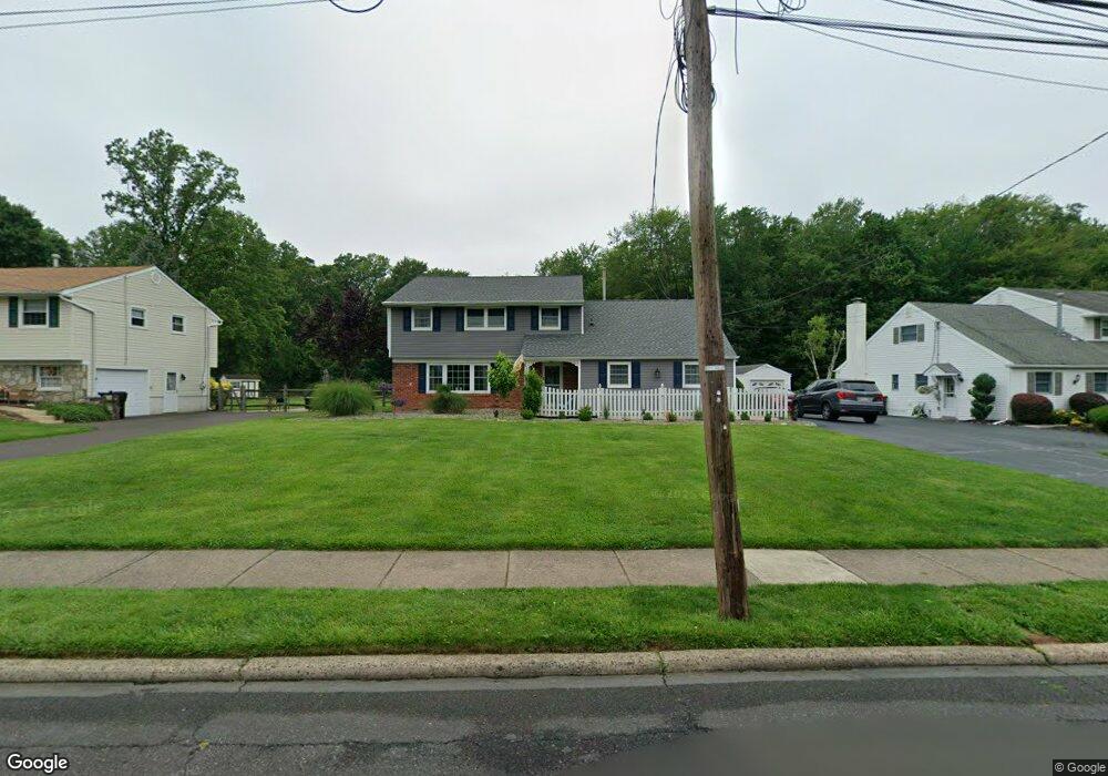
614 Brumar Dr Hatboro, PA 19040
Estimated Value: $547,018 - $639,000
5
Beds
3
Baths
2,625
Sq Ft
$223/Sq Ft
Est. Value
About This Home
This home is located at 614 Brumar Dr, Hatboro, PA 19040 and is currently estimated at $586,005, approximately $223 per square foot. 614 Brumar Dr is a home located in Montgomery County with nearby schools including Hallowell Elementary School, Keith Valley Middle School, and Hatboro-Horsham High School.
Ownership History
Date
Name
Owned For
Owner Type
Purchase Details
Closed on
Apr 29, 2011
Sold by
Rocchi Josephine R and Rocchi Ferdinand A
Bought by
Cruz Jaclyn P and Cruz Jimmy
Current Estimated Value
Home Financials for this Owner
Home Financials are based on the most recent Mortgage that was taken out on this home.
Original Mortgage
$306,000
Outstanding Balance
$212,656
Interest Rate
4.88%
Estimated Equity
$373,349
Create a Home Valuation Report for This Property
The Home Valuation Report is an in-depth analysis detailing your home's value as well as a comparison with similar homes in the area
Home Values in the Area
Average Home Value in this Area
Purchase History
| Date | Buyer | Sale Price | Title Company |
|---|---|---|---|
| Cruz Jaclyn P | $340,000 | None Available |
Source: Public Records
Mortgage History
| Date | Status | Borrower | Loan Amount |
|---|---|---|---|
| Open | Cruz Jaclyn P | $306,000 |
Source: Public Records
Tax History Compared to Growth
Tax History
| Year | Tax Paid | Tax Assessment Tax Assessment Total Assessment is a certain percentage of the fair market value that is determined by local assessors to be the total taxable value of land and additions on the property. | Land | Improvement |
|---|---|---|---|---|
| 2025 | $6,475 | $164,730 | $49,540 | $115,190 |
| 2024 | $6,475 | $164,730 | $49,540 | $115,190 |
| 2023 | $6,163 | $164,730 | $49,540 | $115,190 |
| 2022 | $5,964 | $164,730 | $49,540 | $115,190 |
| 2021 | $5,823 | $164,730 | $49,540 | $115,190 |
| 2020 | $5,685 | $164,730 | $49,540 | $115,190 |
| 2019 | $5,576 | $164,730 | $49,540 | $115,190 |
| 2018 | $4,439 | $164,730 | $49,540 | $115,190 |
| 2017 | $5,327 | $164,730 | $49,540 | $115,190 |
| 2016 | $5,263 | $164,730 | $49,540 | $115,190 |
| 2015 | $5,026 | $164,730 | $49,540 | $115,190 |
| 2014 | $5,026 | $164,730 | $49,540 | $115,190 |
Source: Public Records
Map
Nearby Homes
- 619 Brumar Dr
- 25 Patriot Ln
- 34 Patriot Ln
- 18 Patriot Ln
- 604 Liberty Ridge Rd
- 616 Liberty Ridge Rd
- 603 Liberty Ridge Rd
- 605 Liberty Ridge Rd
- 611 Liberty Ridge Rd
- 623 Liberty Ridge Rd
- 37 Maurice Ln
- 532 Sherwood Ln
- 1309 Clyde Rd
- 711 W County Line Rd
- 422 W Moreland Ave
- 204 Wilson Ave
- 890 Easton Rd
- 176 Westbury Dr
- 216 Wellington Dr
- 287 Essex Rd
- 616 Brumar Dr
- 612 Brumar Dr
- 606 Brumar Dr
- 618 Brumar Dr
- 610 Brumar Dr
- 615 Brumar Dr
- 620 Brumar Dr
- 36 Latchstring Ln
- 613 Brumar Dr
- 608 Brumar Dr
- 611 Brumar Dr
- 622 Brumar Dr
- 609 Brumar Dr
- 34 Latchstring Ln
- 607 Brumar Dr
- 624 Brumar Dr
- 32 Latchstring Ln
- 39 Latchstring Ln
- 30 Latchstring Ln
- 28 Latchstring Ln