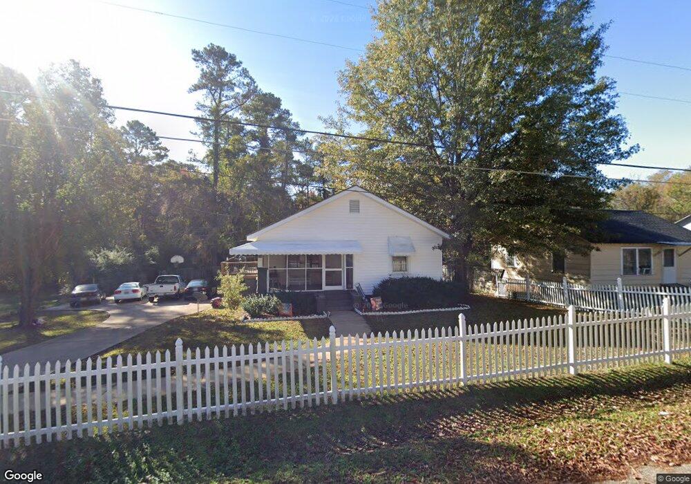
614 Poplar St West Point, GA 31833
Estimated Value: $121,000 - $129,000
3
Beds
2
Baths
1,312
Sq Ft
$96/Sq Ft
Est. Value
About This Home
This home is located at 614 Poplar St, West Point, GA 31833 and is currently estimated at $125,923, approximately $95 per square foot. 614 Poplar St is a home located in Troup County with nearby schools including West Point Elementary School, Long Cane Elementary School, and Berta Weathersbee Elementary School.
Ownership History
Date
Name
Owned For
Owner Type
Purchase Details
Closed on
Jul 19, 1999
Sold by
Timothy H Harmon
Bought by
Gilliam Adrian
Current Estimated Value
Purchase Details
Closed on
Oct 24, 1997
Sold by
Keith Janice D
Bought by
Timothy H Harmon
Purchase Details
Closed on
Oct 23, 1997
Sold by
Phinielia Harmon
Bought by
Keith Janice D
Purchase Details
Closed on
Sep 21, 1989
Bought by
Phinielia Harmon
Purchase Details
Closed on
Jan 1, 1940
Create a Home Valuation Report for This Property
The Home Valuation Report is an in-depth analysis detailing your home's value as well as a comparison with similar homes in the area
Home Values in the Area
Average Home Value in this Area
Purchase History
| Date | Buyer | Sale Price | Title Company |
|---|---|---|---|
| Gilliam Adrian | $45,000 | -- | |
| Timothy H Harmon | $19,500 | -- | |
| Keith Janice D | -- | -- | |
| Phinielia Harmon | -- | -- | |
| -- | -- | -- |
Source: Public Records
Tax History Compared to Growth
Tax History
| Year | Tax Paid | Tax Assessment Tax Assessment Total Assessment is a certain percentage of the fair market value that is determined by local assessors to be the total taxable value of land and additions on the property. | Land | Improvement |
|---|---|---|---|---|
| 2024 | $1,033 | $29,192 | $1,600 | $27,592 |
| 2023 | $1,040 | $29,204 | $1,600 | $27,604 |
| 2022 | $768 | $27,524 | $1,600 | $25,924 |
| 2021 | $716 | $23,748 | $1,600 | $22,148 |
| 2020 | $716 | $23,748 | $1,600 | $22,148 |
| 2019 | $674 | $22,356 | $1,600 | $20,756 |
| 2018 | $644 | $21,344 | $1,600 | $19,744 |
| 2017 | $644 | $21,344 | $1,600 | $19,744 |
| 2016 | $624 | $20,698 | $1,600 | $19,098 |
| 2015 | $625 | $20,698 | $1,600 | $19,098 |
| 2014 | $416 | $13,760 | $1,600 | $12,160 |
| 2013 | -- | $14,544 | $1,600 | $12,944 |
Source: Public Records
Map
Nearby Homes
- 508 Pine St
- 1903 Ridgewood Dr
- 0 Ga Highway 0116 Unit 10619139
- 1505 Wisteria Dr
- 0 Sunset Dr Unit 10451831
- 1008 E 12th St
- 106 Sunset Dr
- 0 Arrowhead Dr Unit 10451860
- 713 Avenue H
- 1410 Roper Ave
- 1314 4th Ave
- 509 Cleveland St
- 804 E 6th St
- 311 E 4th St
- 712 4th Ave
- 210 N 14th St
- 111 Tudor Way
- 8035 County Road 289
- 112 Hillcrest Rd
- 107 Garden Walk
- 616 Poplar St
- 618 Poplar St
- 608 Poplar St
- 1801 Maple St
- 611 Poplar St
- 0 Poplar St Unit 7027644
- 0 Poplar St Unit 8195867
- 0 Poplar St
- 609 Poplar St
- 604 Poplar St
- 600 Poplar St
- 1802 Spruce St
- 1712 Spruce St
- 0 Spruce St Unit 8624982
- 0 Spruce St Unit 7612301
- 0 Spruce St Unit 3000495
- 0 Spruce St
- 604 Pine St
- 1809 Maple St
- 1702 Fir St