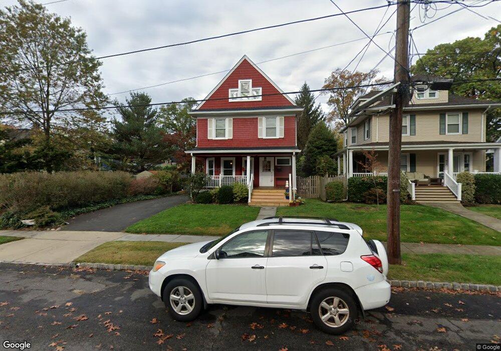
615 Maple St Westfield, NJ 07090
Estimated Value: $1,034,000 - $1,559,000
Studio
--
Bath
2,162
Sq Ft
$589/Sq Ft
Est. Value
About This Home
This home is located at 615 Maple St, Westfield, NJ 07090 and is currently estimated at $1,274,097, approximately $589 per square foot. 615 Maple St is a home located in Union County with nearby schools including Wilson Elementary School, Roosevelt Intermediate School, and Westfield Senior High School.
Ownership History
Date
Name
Owned For
Owner Type
Purchase Details
Closed on
Dec 30, 2008
Sold by
Wilder Mary Anne and Reid John
Bought by
Makely John and Makely Stacey
Current Estimated Value
Home Financials for this Owner
Home Financials are based on the most recent Mortgage that was taken out on this home.
Original Mortgage
$378,000
Outstanding Balance
$249,068
Interest Rate
5.99%
Mortgage Type
Purchase Money Mortgage
Estimated Equity
$1,025,029
Purchase Details
Closed on
Dec 10, 2007
Sold by
Wilder John E and Wilder Mary Anne
Bought by
Wilder Mary Anne
Create a Home Valuation Report for This Property
The Home Valuation Report is an in-depth analysis detailing your home's value as well as a comparison with similar homes in the area
Home Values in the Area
Average Home Value in this Area
Purchase History
| Date | Buyer | Sale Price | Title Company |
|---|---|---|---|
| Makely John | $420,000 | Stewart Title Guaranty Co | |
| Wilder Mary Anne | -- | None Available |
Source: Public Records
Mortgage History
| Date | Status | Borrower | Loan Amount |
|---|---|---|---|
| Open | Makely John | $378,000 |
Source: Public Records
Tax History
| Year | Tax Paid | Tax Assessment Tax Assessment Total Assessment is a certain percentage of the fair market value that is determined by local assessors to be the total taxable value of land and additions on the property. | Land | Improvement |
|---|---|---|---|---|
| 2025 | $15,219 | $688,400 | $470,600 | $217,800 |
| 2024 | $14,681 | $675,800 | $470,600 | $205,200 |
| 2023 | $14,681 | $665,500 | $470,600 | $194,900 |
| 2022 | $14,375 | $665,500 | $470,600 | $194,900 |
| 2021 | $14,395 | $665,500 | $470,600 | $194,900 |
| 2020 | $14,361 | $665,500 | $470,600 | $194,900 |
| 2019 | $14,308 | $665,500 | $470,600 | $194,900 |
| 2018 | $12,941 | $139,200 | $64,800 | $74,400 |
| 2017 | $12,870 | $139,200 | $64,800 | $74,400 |
| 2016 | $12,568 | $139,200 | $64,800 | $74,400 |
| 2015 | $12,318 | $139,200 | $64,800 | $74,400 |
| 2014 | $11,911 | $139,200 | $64,800 | $74,400 |
Source: Public Records
Map
Nearby Homes
- 645 Kimball Ave
- 721 Kimball Ave
- 509 Bradford Ave
- 422 Kimball Ave
- 336 Mountain Ave
- 706 Mountain Ave
- 735 Belvidere Ave
- 611 Bradford Ave
- 418 Colonial Ave
- 714 E Broad St
- 582 Sherwood Pkwy
- 808 Grant Ave
- 634 Lenox Ave
- 515 Woodland Ave
- 260 Prospect St Unit C12
- 629 Tremont Ave
- 424 Saint Marks Ave
- 1061 Wychwood Rd
- 400 Salter Place
- 312 Wells St
Your Personal Tour Guide
Ask me questions while you tour the home.