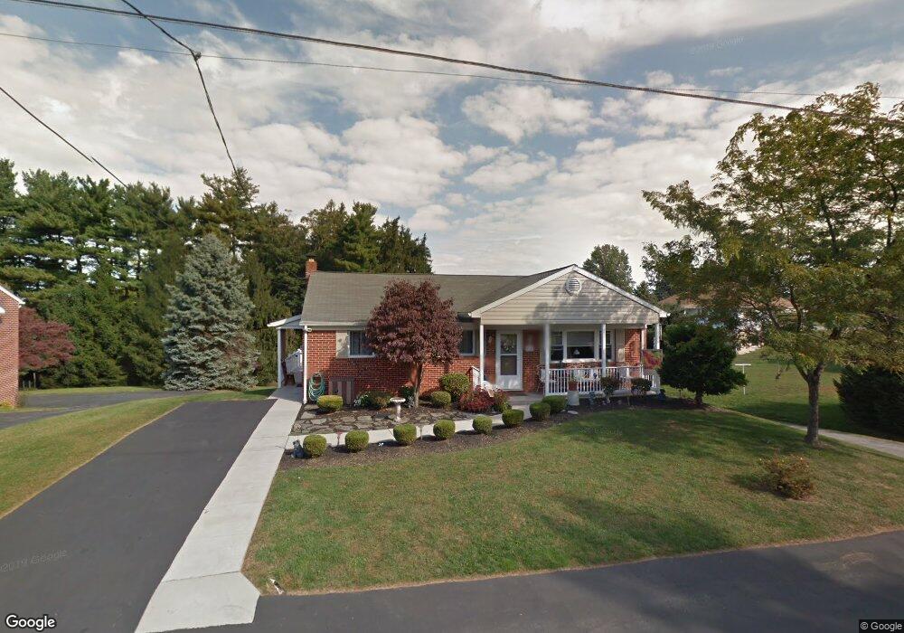
615 Pershing Ave Red Lion, PA 17356
Estimated Value: $243,000 - $262,000
3
Beds
2
Baths
1,176
Sq Ft
$217/Sq Ft
Est. Value
About This Home
This home is located at 615 Pershing Ave, Red Lion, PA 17356 and is currently estimated at $254,648, approximately $216 per square foot. 615 Pershing Ave is a home located in York County with nearby schools including Pleasant View Elementary School, Red Lion Area Junior High School, and Red Lion Area Senior High School.
Ownership History
Date
Name
Owned For
Owner Type
Purchase Details
Closed on
Jun 27, 2024
Sold by
Knokey Jeffrey L and Knokey Debra L
Bought by
Knokey Jeffrey L and Knokey Debra L
Current Estimated Value
Purchase Details
Closed on
Sep 19, 2000
Sold by
Knokey Eathel M
Bought by
Knokey Jeffrey L
Purchase Details
Closed on
Aug 10, 1998
Sold by
Knokey Jeffrey L
Bought by
Knokey Eathel M
Create a Home Valuation Report for This Property
The Home Valuation Report is an in-depth analysis detailing your home's value as well as a comparison with similar homes in the area
Home Values in the Area
Average Home Value in this Area
Purchase History
| Date | Buyer | Sale Price | Title Company |
|---|---|---|---|
| Knokey Jeffrey L | -- | None Listed On Document | |
| Knokey Jeffrey L | -- | -- | |
| Knokey Eathel M | -- | -- |
Source: Public Records
Tax History
| Year | Tax Paid | Tax Assessment Tax Assessment Total Assessment is a certain percentage of the fair market value that is determined by local assessors to be the total taxable value of land and additions on the property. | Land | Improvement |
|---|---|---|---|---|
| 2025 | $3,753 | $120,070 | $33,010 | $87,060 |
| 2024 | $3,606 | $120,070 | $33,010 | $87,060 |
| 2023 | $3,606 | $120,070 | $33,010 | $87,060 |
| 2022 | $3,606 | $120,070 | $33,010 | $87,060 |
| 2021 | $3,504 | $120,070 | $33,010 | $87,060 |
| 2020 | $3,504 | $120,070 | $33,010 | $87,060 |
| 2019 | $3,492 | $120,070 | $33,010 | $87,060 |
| 2018 | $3,474 | $120,070 | $33,010 | $87,060 |
| 2017 | $3,444 | $120,070 | $33,010 | $87,060 |
| 2016 | $0 | $120,070 | $33,010 | $87,060 |
| 2015 | -- | $120,070 | $33,010 | $87,060 |
| 2014 | -- | $120,070 | $33,010 | $87,060 |
Source: Public Records
Map
Nearby Homes
- 300 S Camp St
- 355 S Camp St
- 190 Biglar Ct
- 810 Jefferson Ln
- 282 E Broadway
- 590 Thomas Armor Dr
- 10 Azalea Dr Unit 97
- 495 Thomas Armor Dr
- 157 E Broadway
- 370 Azalea Dr Unit 76
- 0 Burkholder Rd Unit PAYK2092426
- 215 Azalea Dr
- 43 W High St
- 44 Springvale Rd
- 180 Springvale Rd
- 316 W Broadway
- 90 Manor Rd
- 274 N Main St
- 404 N Main St
- 327 1st Ave
- 605 Pershing Ave
- 330 S Camp St
- 575 Pershing Ave
- 620 Pershing Ave
- 610 Pershing Ave
- 320 S Camp St
- 360 S Camp St
- 565 Pershing Ave
- 600 Pershing Ave
- 310 S Camp St
- 334 S Camp St
- 619 E Broadway
- 560 Lindberg Ave
- 625 E Broadway
- 615 E Broadway
- 560 Pershing Ave
- 649 Jefferson Ln
- 635 E Broadway
- 617 Pershing Ave
- 605 E Broadway
Your Personal Tour Guide
Ask me questions while you tour the home.