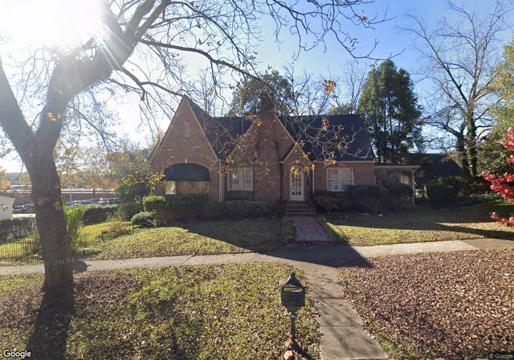
615 W 10th St West Point, GA 31833
Estimated Value: $287,511 - $407,000
3
Beds
3
Baths
3,022
Sq Ft
$108/Sq Ft
Est. Value
About This Home
This home is located at 615 W 10th St, West Point, GA 31833 and is currently estimated at $325,878, approximately $107 per square foot. 615 W 10th St is a home located in Troup County with nearby schools including West Point Elementary School, Long Cane Elementary School, and Whitesville Road Elementary School.
Ownership History
Date
Name
Owned For
Owner Type
Purchase Details
Closed on
Aug 12, 2019
Sold by
Blackstone Gail T
Bought by
Lewis Wayne Edward and Lewis Melissa J
Current Estimated Value
Home Financials for this Owner
Home Financials are based on the most recent Mortgage that was taken out on this home.
Original Mortgage
$214,515
Outstanding Balance
$187,876
Interest Rate
3.7%
Mortgage Type
New Conventional
Estimated Equity
$138,003
Purchase Details
Closed on
Nov 8, 2017
Sold by
Blackstone James
Bought by
Blackstone Gail T
Purchase Details
Closed on
Jul 16, 1998
Sold by
Crowder Etal
Bought by
Keller Ollie
Purchase Details
Closed on
Feb 2, 1998
Sold by
Estate Lucille Jones
Bought by
Crowder Etal
Purchase Details
Closed on
Jan 1, 1934
Bought by
Estate Lucille Jones
Create a Home Valuation Report for This Property
The Home Valuation Report is an in-depth analysis detailing your home's value as well as a comparison with similar homes in the area
Home Values in the Area
Average Home Value in this Area
Purchase History
| Date | Buyer | Sale Price | Title Company |
|---|---|---|---|
| Lewis Wayne Edward | $210,000 | -- | |
| Blackstone Gail T | -- | -- | |
| Keller Ollie | $83,000 | -- | |
| Crowder Etal | -- | -- | |
| Estate Lucille Jones | -- | -- |
Source: Public Records
Mortgage History
| Date | Status | Borrower | Loan Amount |
|---|---|---|---|
| Open | Lewis Wayne Edward | $214,515 |
Source: Public Records
Tax History Compared to Growth
Tax History
| Year | Tax Paid | Tax Assessment Tax Assessment Total Assessment is a certain percentage of the fair market value that is determined by local assessors to be the total taxable value of land and additions on the property. | Land | Improvement |
|---|---|---|---|---|
| 2024 | $3,550 | $87,920 | $13,080 | $74,840 |
| 2023 | $3,427 | $84,400 | $13,080 | $71,320 |
| 2022 | $2,210 | $79,200 | $13,080 | $66,120 |
| 2021 | $2,216 | $73,480 | $3,920 | $69,560 |
| 2020 | $2,216 | $73,480 | $3,920 | $69,560 |
| 2019 | $2,015 | $66,800 | $3,920 | $62,880 |
Source: Public Records
Map
Nearby Homes
- 1007 4th Ave
- 1508 N 4th Ave
- 1314 4th Ave
- 712 4th Ave
- 1410 Roper Ave
- 909 N 13th St
- 811 Cherry Dr
- 813 Cherry Dr
- 514 N 8th Ave
- 302 N 6th Ave
- 304 N 11th Ave Unit N 11th Ave
- 311 E 4th St
- 806 N 5th St
- 1114 N 18th St
- 1505 Wisteria Dr
- 713 Avenue H
- 1008 E 12th St
- 804 E 6th St
- 1110 N 3rd St
- 0 Arrowhead Dr Unit 10451860