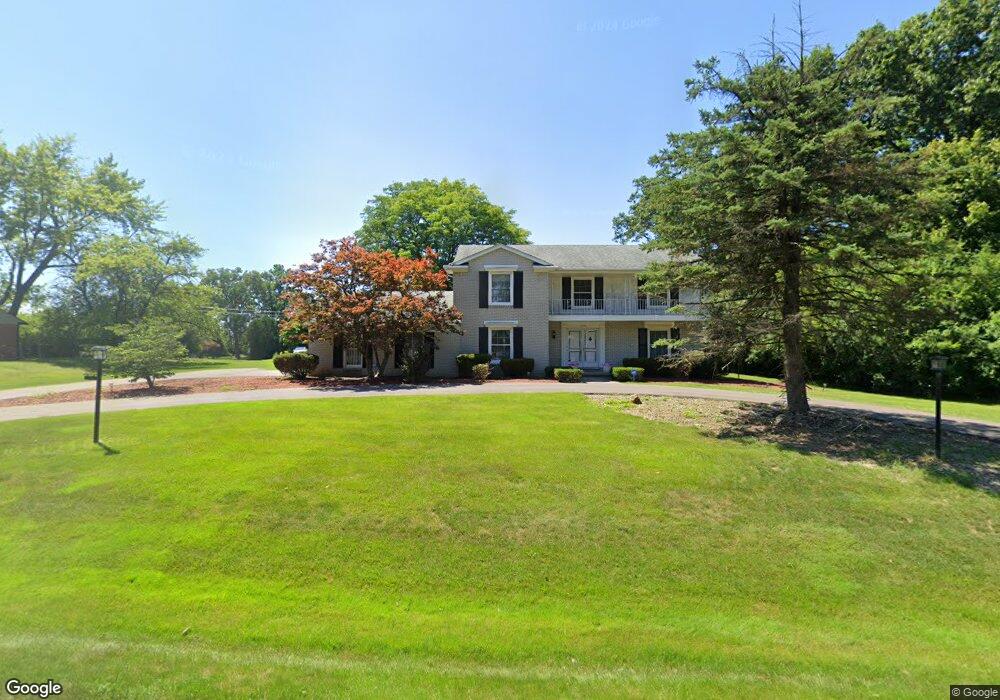
6150 Buxton Dr West Bloomfield, MI 48322
Estimated Value: $439,000 - $584,000
4
Beds
3
Baths
2,922
Sq Ft
$172/Sq Ft
Est. Value
About This Home
This home is located at 6150 Buxton Dr, West Bloomfield, MI 48322 and is currently estimated at $503,083, approximately $172 per square foot. 6150 Buxton Dr is a home located in Oakland County with nearby schools including Sheiko Elementary School, West Bloomfield Middle School, and Bloomfield Maples Montessori.
Ownership History
Date
Name
Owned For
Owner Type
Purchase Details
Closed on
Feb 1, 2022
Sold by
Denise Willis
Bought by
Denise D Willis Revocable Trust
Current Estimated Value
Purchase Details
Closed on
May 4, 2017
Sold by
Willis Denise and Willis Denise D
Bought by
Willis Denise D and Collins Barbara
Home Financials for this Owner
Home Financials are based on the most recent Mortgage that was taken out on this home.
Original Mortgage
$228,000
Interest Rate
4.14%
Mortgage Type
New Conventional
Purchase Details
Closed on
Jul 23, 2013
Sold by
Willis Clarence
Bought by
Willis Denise
Create a Home Valuation Report for This Property
The Home Valuation Report is an in-depth analysis detailing your home's value as well as a comparison with similar homes in the area
Home Values in the Area
Average Home Value in this Area
Purchase History
| Date | Buyer | Sale Price | Title Company |
|---|---|---|---|
| Denise D Willis Revocable Trust | -- | None Listed On Document | |
| Willis Denise D | -- | None Available | |
| Willis Denise | -- | None Available |
Source: Public Records
Mortgage History
| Date | Status | Borrower | Loan Amount |
|---|---|---|---|
| Previous Owner | Willis Denise D | $228,000 |
Source: Public Records
Tax History Compared to Growth
Tax History
| Year | Tax Paid | Tax Assessment Tax Assessment Total Assessment is a certain percentage of the fair market value that is determined by local assessors to be the total taxable value of land and additions on the property. | Land | Improvement |
|---|---|---|---|---|
| 2024 | $2,825 | $185,950 | $0 | $0 |
| 2022 | $2,705 | $164,700 | $34,100 | $130,600 |
| 2021 | $4,065 | $162,030 | $0 | $0 |
| 2020 | $2,621 | $156,540 | $34,100 | $122,440 |
| 2018 | $3,919 | $141,960 | $29,600 | $112,360 |
| 2015 | -- | $110,920 | $0 | $0 |
| 2014 | -- | $102,920 | $0 | $0 |
| 2011 | -- | $94,550 | $0 | $0 |
Source: Public Records
Map
Nearby Homes
- 6151 Orchard Lake Rd Unit 103
- 6145 Orchard Lake Rd Unit 204
- 6109 Orchard Lake Rd Unit 101
- 3865 Stonecrest Rd
- 6322 Pepper Hill St Unit 62
- 6222 Pepper Hill St
- 5780 Swan Lake Ct
- 6624 Mellow Wood Ln
- 4161 Breckenridge Dr
- 5946 Cherry Crest Dr
- 6843 Leslee Crest Dr
- 6769 Heather Heath
- 5622 Powder Horn Dr
- 3035 Parkland Dr
- 6651 Hearthside Ct Unit 1
- 6614 Embers Ct
- 6621 Bellows Ct Unit 62
- 3930 Harris Ln
- 7027 Beverly Crest Dr
- 6564 Alderley Way
- 6180 Buxton Dr
- 6118 Buxton Dr
- 6171 Nicholas Dr
- 6153 Nicholas Dr
- 6161 Buxton Dr
- 6119 Buxton Dr
- 6189 Nicholas Dr
- 6074 Wellesley Dr
- 6131 Nicholas Dr
- 6191 Buxton Dr
- 6126 Wellesley Dr
- 6207 Nicholas Dr
- 6095 Wellesley Dr
- 6156 Nicholas Dr
- 6120 Wellesley Ct
- 6182 Nicholas Dr
- 6146 Wellesley Dr
- 6056 Wellesley Dr
- 6071 Wellesley Dr
- 6225 Tamerlane Dr