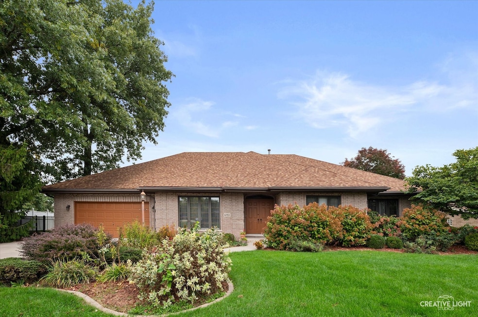

6150 W 124th St Palos Heights, IL 60463
Navajo Hills NeighborhoodEstimated payment $3,935/month
Highlights
- Open Floorplan
- Deck
- Whirlpool Bathtub
- Chippewa Elementary School Rated A-
- Ranch Style House
- Walk-In Pantry
About This Home
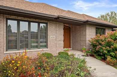
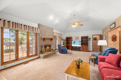
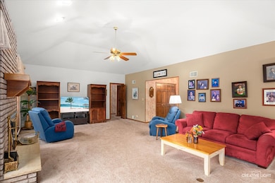
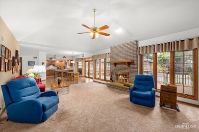
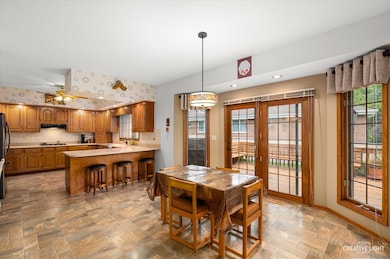
All-brick 4 bed, 3 bath home with 2.5-car garage, fenced yard, and a spacious deck with natural gas line for grilling. Inside are 9 ft ceilings, dual HVAC, a bright family room with tray ceiling, ceiling fan, gas brick fireplace, and abundant natural light. The eat-in kitchen offers a breakfast bar, Corian counters, walk-in pantry, can lighting, plenty of cabinets and counter space, and a vent hood that exhausts outside. Formal dining room with crown molding fits a large table for entertaining. The primary suite features deck access, a large walk-in closet, and a generous bath with abundant storage, step-in shower, and tub. Down the hall are three well-sized bedrooms, two full baths with quartz counters, two linen closets, and a laundry room with cabinets, counter space, utility sink, and window. The large unfinished basement includes rough-in plumbing. Major updates and features: LeafGuard gutter system with transferable lifetime warranty, new water heater (2025), all insulation replaced and upgraded including basement (2024), deck stained (2024), microwave (2023), two humidifiers (2022), two AC units (2021), double oven (2018), refrigerator (2017), concrete driveway and sidewalks (2016), and roof (2014).
Home Details
Home Type
- Single Family
Est. Annual Taxes
- $11,040
Year Built
- Built in 1990
Lot Details
- 0.3 Acre Lot
- Lot Dimensions are 64x59x95x120x120
- Fenced
- Paved or Partially Paved Lot
Parking
- 2.5 Car Garage
- Driveway
- Parking Included in Price
Home Design
- Ranch Style House
- Brick Exterior Construction
- Asphalt Roof
- Concrete Perimeter Foundation
Interior Spaces
- 3,257 Sq Ft Home
- Open Floorplan
- Crown Molding
- Wood Burning Fireplace
- Fireplace With Gas Starter
- Window Screens
- Six Panel Doors
- Family Room with Fireplace
- Living Room
- Formal Dining Room
- Carpet
- Basement Fills Entire Space Under The House
Kitchen
- Breakfast Bar
- Walk-In Pantry
- Double Oven
- Microwave
- Dishwasher
- Disposal
Bedrooms and Bathrooms
- 4 Bedrooms
- 4 Potential Bedrooms
- Walk-In Closet
- Bathroom on Main Level
- 3 Full Bathrooms
- Whirlpool Bathtub
- Separate Shower
Laundry
- Laundry Room
- Dryer
- Washer
- Sink Near Laundry
Schools
- Chippewa Elementary School
- Independence Junior High School
- A B Shepard High School (Campus
Utilities
- Forced Air Zoned Heating and Cooling System
- Heating System Uses Natural Gas
- Lake Michigan Water
Additional Features
- Doors with lever handles
- Deck
Community Details
- Country Trails Subdivision, Ranch Floorplan
Listing and Financial Details
- Senior Tax Exemptions
- Homeowner Tax Exemptions
Map
Home Values in the Area
Average Home Value in this Area
Tax History
| Year | Tax Paid | Tax Assessment Tax Assessment Total Assessment is a certain percentage of the fair market value that is determined by local assessors to be the total taxable value of land and additions on the property. | Land | Improvement |
|---|---|---|---|---|
| 2024 | $11,040 | $42,438 | $8,076 | $34,362 |
| 2023 | $12,516 | $42,438 | $8,076 | $34,362 |
| 2022 | $12,516 | $40,818 | $7,107 | $33,711 |
| 2021 | $12,005 | $40,816 | $7,106 | $33,710 |
| 2020 | $11,916 | $40,816 | $7,106 | $33,710 |
| 2019 | $10,885 | $39,030 | $6,460 | $32,570 |
| 2018 | $10,302 | $39,030 | $6,460 | $32,570 |
| 2017 | $10,328 | $39,030 | $6,460 | $32,570 |
| 2016 | $9,782 | $34,054 | $5,491 | $28,563 |
| 2015 | $10,748 | $37,905 | $5,491 | $32,414 |
| 2014 | $10,464 | $37,905 | $5,491 | $32,414 |
| 2013 | $9,861 | $38,613 | $5,491 | $33,122 |
Property History
| Date | Event | Price | List to Sale | Price per Sq Ft |
|---|---|---|---|---|
| 10/29/2025 10/29/25 | Price Changed | $574,900 | -3.4% | $177 / Sq Ft |
| 10/17/2025 10/17/25 | For Sale | $595,000 | -- | $183 / Sq Ft |
Purchase History
| Date | Type | Sale Price | Title Company |
|---|---|---|---|
| Warranty Deed | -- | None Listed On Document | |
| Deed | -- | -- | |
| Trustee Deed | -- | -- |
Mortgage History
| Date | Status | Loan Amount | Loan Type |
|---|---|---|---|
| Previous Owner | $148,000 | No Value Available | |
| Closed | $270,000 | No Value Available |
Source: Midwest Real Estate Data (MRED)
MLS Number: 12495650
APN: 24-29-300-018-0000
Disclaimer: Certain information contained herein is derived from information provided by parties other than Homes.com. All information provided is deemed reliable, but is not guaranteed to be accurate and should be independently verified.
![]() Based on information submitted to the MLS GRID. All data is obtained from various sources and may not have been verified by broker or MLS GRID. Supplied Open House Information is subject to change without notice. All information should be independently reviewed and verified for accuracy. Properties may or may not be listed by the office/agent presenting the information. Some IDX listings have been excluded from this website.
Based on information submitted to the MLS GRID. All data is obtained from various sources and may not have been verified by broker or MLS GRID. Supplied Open House Information is subject to change without notice. All information should be independently reviewed and verified for accuracy. Properties may or may not be listed by the office/agent presenting the information. Some IDX listings have been excluded from this website.
The Digital Millennium Copyright Act of 1998, 17 U.S.C. § 512 (the “DMCA”) provides recourse for copyright owners who believe that material appearing on the Internet infringes their rights under U.S. copyright law. If you believe in good faith that any content or material made available in connection with our website or services infringes your copyright, you (or your agent) may send us a notice requesting that the content or material be removed, or access to it blocked.
Notices must be sent in writing by email to DMCAnotice@MLSGrid.com.
The DMCA requires that your notice of alleged copyright infringement include the following information:
(1) description of the copyrighted work that is the subject of claimed infringement;
(2) description of the alleged infringing content and information sufficient to permit us to locate the content;
(3) contact information for you, including your address, telephone number and email address;
(4) a statement by you that you have a good faith belief that the content in the manner complained of is not authorized by the copyright owner, or its agent, or by the operation of any law;
(5) a statement by you, signed under penalty of perjury, that the information in the notification is accurate and that you have the authority to enforce the copyrights that are claimed to be infringed; and
(6) a physical or electronic signature of the copyright owner or a person authorized to act on the copyright owner’s behalf. Failure to include all of the above information may result in the delay of the processing of your complaint.
- 12300 S Austin Ave
- 12857 S Austin Ave
- 12443 S Mcvickers Ave
- 5942 W 124th St
- 12513 S Mcvickers Ave
- 5844 W 124th St
- 12557 S Mason Ave
- 6052 W 128th St
- 6519 W 126th Place
- 9208 S Monitor Ave
- 6709 W Menominee Pkwy
- 5821 W 127th St
- 6711 W Shiawassie Dr
- 6220 W 129th Place
- 6052 W 129th Place
- 12613 S Parkside Ave
- 12649 S Parkside Ave
- 12642 S Central Ave
- 12721 Park Place Unit 2B
- 206 Sawgrass Dr
- 6031 W 129th St
- 11760 S Ridgeland Ave Unit 6D
- 5723 129th St Unit 7F
- 12804 W Playfield Dr Unit ID1330088P
- 12800 Terrace Ln Unit ID1330089P
- 12715 S La Crosse Ave Unit 104
- 0 11011-11013 S Lloyd Dr
- 12255 S Mcdaniels St Unit GN
- 10850 Parkside Ave
- 4622 W 122nd St
- 10720 S Ridgeland Ave
- 10720 S Ridgeland Ave Unit 9
- 6834 W Lode Dr Unit 1B
- 7137 W 109th Place
- 10624 Mayfield Ave Unit 2
- 5818 107th Court Way Unit 10
- 12713 S 80th Ave
- 11600 S Kilbourn Ave
- 10520 Ridgeland Ave
- 10442 Brooks Ln Unit C1
