Estimated Value: $486,000 - $545,086
2
Beds
2
Baths
1,068
Sq Ft
$488/Sq Ft
Est. Value
About This Home
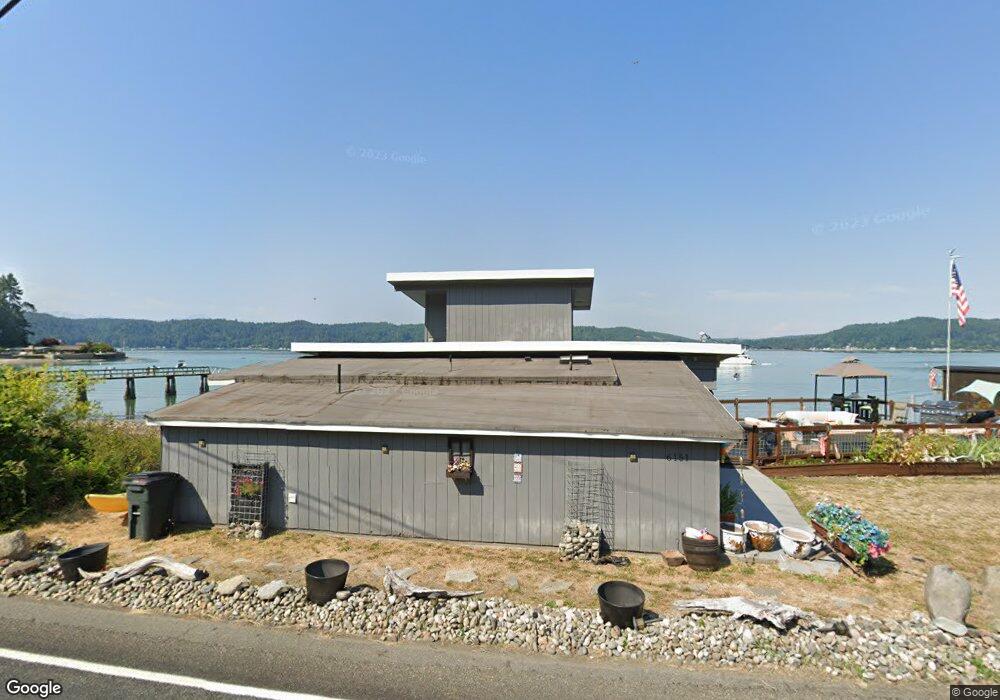
This home is located at 6151 E State Route 106, Union, WA 98592 and is currently estimated at $520,772, approximately $487 per square foot. 6151 E State Route 106 is a home located in Mason County with nearby schools including Hood Canal Elementary/Junior High School.
Ownership History
Date
Name
Owned For
Owner Type
Purchase Details
Closed on
Mar 22, 2011
Sold by
Richardson James E
Bought by
Donley Carol Loulee O
Current Estimated Value
Home Financials for this Owner
Home Financials are based on the most recent Mortgage that was taken out on this home.
Original Mortgage
$174,000
Interest Rate
4.96%
Mortgage Type
Unknown
Purchase Details
Closed on
Mar 16, 2011
Sold by
Donley Carol Louse O
Bought by
Halvorson Jill Darlene
Home Financials for this Owner
Home Financials are based on the most recent Mortgage that was taken out on this home.
Original Mortgage
$174,000
Interest Rate
4.96%
Mortgage Type
Unknown
Purchase Details
Closed on
Mar 11, 2011
Sold by
Richardson Grace O
Bought by
Donley Carol Louise
Home Financials for this Owner
Home Financials are based on the most recent Mortgage that was taken out on this home.
Original Mortgage
$174,000
Interest Rate
4.96%
Mortgage Type
Unknown
Create a Home Valuation Report for This Property
The Home Valuation Report is an in-depth analysis detailing your home's value as well as a comparison with similar homes in the area
Home Values in the Area
Average Home Value in this Area
Purchase History
| Date | Buyer | Sale Price | Title Company |
|---|---|---|---|
| Donley Carol Loulee O | -- | Land Title Co | |
| Halvorson Jill Darlene | $200,281 | Land Title Co | |
| Donley Carol Louise | -- | Land Title Co |
Source: Public Records
Mortgage History
| Date | Status | Borrower | Loan Amount |
|---|---|---|---|
| Closed | Halvorson Jill Darlene | $174,000 |
Source: Public Records
Tax History Compared to Growth
Tax History
| Year | Tax Paid | Tax Assessment Tax Assessment Total Assessment is a certain percentage of the fair market value that is determined by local assessors to be the total taxable value of land and additions on the property. | Land | Improvement |
|---|---|---|---|---|
| 2025 | $3,356 | $476,575 | $171,590 | $304,985 |
| 2023 | $3,356 | $463,985 | $306,410 | $157,575 |
| 2022 | $3,900 | $425,680 | $328,765 | $96,915 |
| 2021 | $4,361 | $425,680 | $328,765 | $96,915 |
| 2020 | $3,065 | $425,330 | $332,420 | $92,910 |
| 2018 | $2,561 | $285,245 | $204,700 | $80,545 |
| 2017 | $2,563 | $285,275 | $204,730 | $80,545 |
| 2016 | $2,561 | $255,635 | $185,595 | $70,040 |
| 2015 | $2,589 | $261,990 | $191,335 | $70,655 |
| 2014 | -- | $261,375 | $191,335 | $70,040 |
| 2013 | -- | $220,040 | $150,000 | $70,040 |
Source: Public Records
Map
Nearby Homes
- 0 Sprague Ave Unit NWM2432096
- 0 Sprague Ave Unit NWM2432045
- 0 E Mason Ave
- 130 E Tacoma St
- 160 E Spruce St
- Xxx E Gerbing View Dr
- 320 E 4th St
- 0 E Gerbing View Dr Unit NWM2372859
- 971 E Manzanita Dr
- 4590 E State Route 106
- XXX E Gerbing View Dr
- 471 E Jack Pine Ln
- 530 E Country Club Dr E
- 61 E Mt Ellinor Ct
- 91 E Jack Pine Ln
- 11 E Bonnie Ct
- 280 E Laurel Park
- 111 E Covey Run
- 91 E Westwood Ln E
- 770 E Country Club Dr E
- 31 Lot Highway 106
- 6780 Highway 106
- 11082 Highway 106
- 4440 Highway 106
- 8750 Highway 106
- 8750 e Highway 106
- 10 Lot Highway 106
- 0 LOT 1 Highway 106
- 10 Highway 106
- 0 L10 Highway 106
- 882 X Highway 106
- 420 X Highway 106
- 4200 Highway 106
- 0 XXX Highway 106
- 6885 Highway 106
- 0 L3,4 Highway 106
- 0 T#7 Highway 106
- 0 TR B Highway 106
- 0 TR C Highway 106
- 0 TR A Highway 106