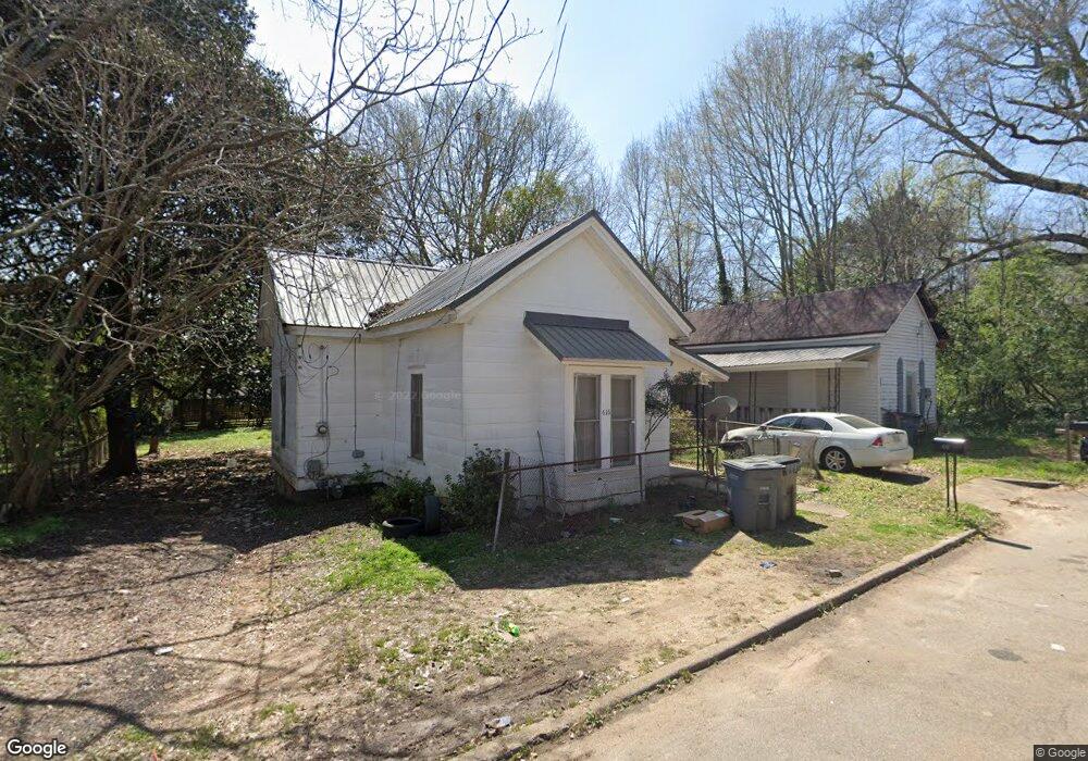
616 Arthur St Lagrange, GA 30241
Estimated Value: $54,000 - $105,509
3
Beds
2
Baths
864
Sq Ft
$91/Sq Ft
Est. Value
About This Home
This home is located at 616 Arthur St, Lagrange, GA 30241 and is currently estimated at $78,377, approximately $90 per square foot. 616 Arthur St is a home with nearby schools including Franklin Forest Elementary School, Hollis Hand Elementary School, and Ethel W. Kight Elementary School.
Ownership History
Date
Name
Owned For
Owner Type
Purchase Details
Closed on
Nov 30, 2021
Sold by
T Squared 1 Llc
Bought by
Brbrshy Investments Inc
Current Estimated Value
Purchase Details
Closed on
Jun 1, 2021
Sold by
Stribling Ty
Bought by
T Squared 2 Llc
Purchase Details
Closed on
Oct 13, 2003
Sold by
Martin J Miller
Bought by
Stribling Ty
Purchase Details
Closed on
Mar 1, 2001
Sold by
Richlan Properties Unlimited L
Bought by
Martin J Miller
Purchase Details
Closed on
Oct 16, 1996
Sold by
Mary Evelyn Crenshaw
Bought by
Richlan Properties Unlimited L
Purchase Details
Closed on
Jan 27, 1995
Sold by
Crenshaw Curtiss
Bought by
Mary Evelyn Crenshaw
Purchase Details
Closed on
Aug 17, 1976
Bought by
Crenshaw Curtiss
Purchase Details
Closed on
Jan 1, 1972
Sold by
Dence Crenshaw
Create a Home Valuation Report for This Property
The Home Valuation Report is an in-depth analysis detailing your home's value as well as a comparison with similar homes in the area
Purchase History
| Date | Buyer | Sale Price | Title Company |
|---|---|---|---|
| Brbrshy Investments Inc | $12,484,500 | -- | |
| T Squared 2 Llc | -- | -- | |
| Stribling Ty | $1,181,000 | -- | |
| Martin J Miller | $345,000 | -- | |
| Richlan Properties Unlimited L | $15,000 | -- | |
| Mary Evelyn Crenshaw | -- | -- | |
| Crenshaw Curtiss | -- | -- | |
| -- | -- | -- |
Source: Public Records
Tax History
| Year | Tax Paid | Tax Assessment Tax Assessment Total Assessment is a certain percentage of the fair market value that is determined by local assessors to be the total taxable value of land and additions on the property. | Land | Improvement |
|---|---|---|---|---|
| 2025 | $610 | $22,360 | $2,000 | $20,360 |
| 2024 | $545 | $20,000 | $2,000 | $18,000 |
| 2023 | $362 | $13,280 | $2,000 | $11,280 |
| 2022 | $355 | $12,720 | $2,000 | $10,720 |
| 2021 | $173 | $5,720 | $2,000 | $3,720 |
| 2020 | $173 | $5,720 | $2,000 | $3,720 |
| 2019 | $150 | $4,960 | $1,600 | $3,360 |
| 2018 | $150 | $4,960 | $1,600 | $3,360 |
| 2017 | $150 | $4,960 | $1,600 | $3,360 |
| 2016 | $141 | $4,660 | $1,510 | $3,150 |
| 2015 | $141 | $4,660 | $1,510 | $3,150 |
| 2014 | $141 | $4,660 | $1,510 | $3,150 |
| 2013 | -- | $5,119 | $1,510 | $3,609 |
Source: Public Records
Map
Nearby Homes
- 614 Arthur St
- 618 Arthur St
- 613 Arthur St
- 615 Arthur St
- 610 Chattahoochee St
- 617 Arthur St
- 618 Chattahoochee St
- 613 Greenville St
- 624 Arthur St
- 615 Greenville St
- 203 Front St
- 620 Chattahoochee St
- 611 Greenville St
- 617 Greenville St
- 619 Arthur St
- 609 Chattahoochee St
- 200 Horace King St
- 110 Horace King St
- 609 Greenville St
- 619 Greenville St
Your Personal Tour Guide
Ask me questions while you tour the home.