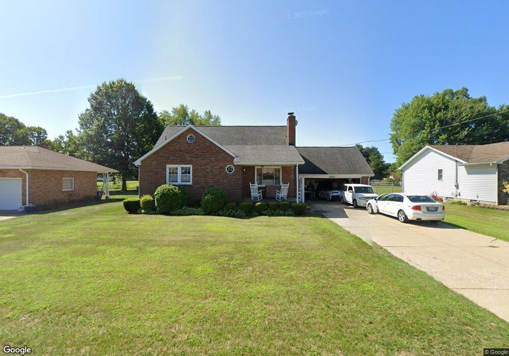
616 W Omar St Struthers, OH 44471
Estimated Value: $212,000 - $263,000
3
Beds
2
Baths
1,847
Sq Ft
$127/Sq Ft
Est. Value
About This Home
This home is located at 616 W Omar St, Struthers, OH 44471 and is currently estimated at $233,839, approximately $126 per square foot. 616 W Omar St is a home located in Mahoning County with nearby schools including Struthers Elementary School, Struthers Middle School, and Struthers High School.
Ownership History
Date
Name
Owned For
Owner Type
Purchase Details
Closed on
Aug 30, 1996
Sold by
Finocchio Mark F
Bought by
Patrick James and Patrick Deborah K
Current Estimated Value
Home Financials for this Owner
Home Financials are based on the most recent Mortgage that was taken out on this home.
Original Mortgage
$59,250
Interest Rate
8.3%
Mortgage Type
New Conventional
Purchase Details
Closed on
Aug 4, 1993
Bought by
Finocchio Mark F
Create a Home Valuation Report for This Property
The Home Valuation Report is an in-depth analysis detailing your home's value as well as a comparison with similar homes in the area
Home Values in the Area
Average Home Value in this Area
Purchase History
| Date | Buyer | Sale Price | Title Company |
|---|---|---|---|
| Patrick James | $79,900 | -- | |
| Finocchio Mark F | -- | -- |
Source: Public Records
Mortgage History
| Date | Status | Borrower | Loan Amount |
|---|---|---|---|
| Previous Owner | Patrick James | $59,250 |
Source: Public Records
Tax History
| Year | Tax Paid | Tax Assessment Tax Assessment Total Assessment is a certain percentage of the fair market value that is determined by local assessors to be the total taxable value of land and additions on the property. | Land | Improvement |
|---|---|---|---|---|
| 2025 | $2,242 | $53,870 | $6,200 | $47,670 |
| 2024 | $2,242 | $53,870 | $6,200 | $47,670 |
| 2023 | $2,204 | $53,870 | $6,200 | $47,670 |
| 2022 | $2,219 | $41,080 | $5,250 | $35,830 |
| 2021 | $2,199 | $41,080 | $5,250 | $35,830 |
| 2020 | $2,209 | $41,080 | $5,250 | $35,830 |
| 2019 | $2,113 | $35,720 | $4,560 | $31,160 |
| 2018 | $2,016 | $35,720 | $4,560 | $31,160 |
| 2017 | $2,013 | $35,720 | $4,560 | $31,160 |
| 2016 | $2,018 | $36,640 | $5,330 | $31,310 |
| 2015 | $1,971 | $36,640 | $5,330 | $31,310 |
| 2014 | $1,978 | $36,640 | $5,330 | $31,310 |
| 2013 | $1,838 | $36,640 | $5,330 | $31,310 |
Source: Public Records
Map
Nearby Homes
- 2089 Shetland Ln
- 563 Geneva Ave
- 5710 Youngstown Poland Rd
- 453 W Omar St
- 587 Edison St
- 1933 Brandon Ave
- 1926 Brandon Ave
- 5425 Sheridan Rd
- 611 W Wilson St
- 2301 Lyon Blvd
- 2370 Lyon Blvd
- 1928 Palo Verde Dr
- 0 Oles Ave
- 1913 Country Club Ave
- 0 Woodlawn Ave
- 5007 Sheridan Rd
- 2035 Woodward Ave
- 2350 Hamilton Ave
- 795 5th St
- 1054 Runge Ave
- 610 W Omar St
- 620 W Omar St
- 604 W Omar St
- 628 W Omar St
- 598 W Omar St
- 613 W Omar St
- 623 W Omar St Unit 625
- 611 W Omar St
- 592 W Omar St
- 2086 W Manor Ave
- 599 W Omar St
- 5137 Youngstown Poland Rd
- 2064 W Manor Ave
- 586 W Omar St
- 593 W Omar St
- 2052 W Manor Ave
- 5119 Youngstown Poland Rd
- 2076 W Manor Ave
- 2042 W Manor Ave
- 614 W Harvey St
Your Personal Tour Guide
Ask me questions while you tour the home.