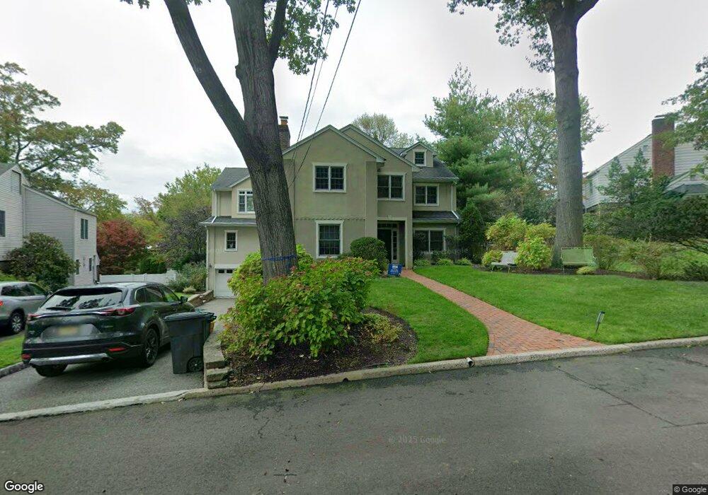
617 N Forest Dr Teaneck, NJ 07666
Estimated Value: $1,704,794 - $1,917,000
Studio
--
Bath
4,839
Sq Ft
$374/Sq Ft
Est. Value
About This Home
This home is located at 617 N Forest Dr, Teaneck, NJ 07666 and is currently estimated at $1,809,199, approximately $373 per square foot. 617 N Forest Dr is a home located in Bergen County with nearby schools including Teaneck Senior High School, Grace Lutheran School, and Yeshivat He'atid.
Ownership History
Date
Name
Owned For
Owner Type
Purchase Details
Closed on
Nov 14, 1994
Sold by
Utility Packaging Corp
Bought by
Levi Ernest and Levi Sallie
Current Estimated Value
Home Financials for this Owner
Home Financials are based on the most recent Mortgage that was taken out on this home.
Original Mortgage
$189,000
Interest Rate
8.9%
Create a Home Valuation Report for This Property
The Home Valuation Report is an in-depth analysis detailing your home's value as well as a comparison with similar homes in the area
Home Values in the Area
Average Home Value in this Area
Purchase History
| Date | Buyer | Sale Price | Title Company |
|---|---|---|---|
| Levi Ernest | $252,500 | -- |
Source: Public Records
Mortgage History
| Date | Status | Borrower | Loan Amount |
|---|---|---|---|
| Closed | Levi Ernest | $189,000 |
Source: Public Records
Tax History
| Year | Tax Paid | Tax Assessment Tax Assessment Total Assessment is a certain percentage of the fair market value that is determined by local assessors to be the total taxable value of land and additions on the property. | Land | Improvement |
|---|---|---|---|---|
| 2025 | $31,275 | $1,432,000 | $444,600 | $987,400 |
| 2024 | $31,389 | $1,432,000 | $444,600 | $987,400 |
| 2023 | $30,771 | $950,600 | $262,300 | $688,300 |
| 2022 | $30,771 | $950,600 | $262,300 | $688,300 |
| 2021 | $30,952 | $950,600 | $262,300 | $688,300 |
| 2020 | $30,742 | $950,600 | $262,300 | $688,300 |
| 2019 | $30,391 | $950,600 | $262,300 | $688,300 |
| 2018 | $30,163 | $950,600 | $262,300 | $688,300 |
| 2017 | $29,877 | $950,600 | $262,300 | $688,300 |
| 2016 | $29,431 | $950,600 | $262,300 | $688,300 |
| 2015 | $28,965 | $950,600 | $262,300 | $688,300 |
| 2014 | $29,567 | $1,150,000 | $362,300 | $787,700 |
Source: Public Records
Map
Nearby Homes
- 633 Wilmerding Ave
- 711 Camperdown Rd
- 1284 Wellington Ave
- 506 Sunderland Rd
- 649 Ogden Ave
- 654 Suffern Rd
- 624 Ramapo Rd
- 700 Ramapo Rd
- 1105 Belle Ave
- 1500 River Rd
- 532 Winthrop Rd
- 364 Billington Rd
- 995 Grace Terrace
- 940 Garrison Ave
- 489 Maple Ave
- 593 Beverly Rd
- 857 Garrison Ave
- 1153 Queen Anne Rd
- 160 Pinewood Place
- 50 Highgate Terrace
- 621 N Forest Dr
- 1262 N Strand
- 626 Sunderland Rd
- 632 Sunderland Rd
- 1274 N Strand
- 625 N Forest Dr
- 638 Sunderland Rd
- 608 N Forest Dr
- 642 Sunderland Rd
- 628 N Forest Dr
- 637 N Forest Dr
- 1277 N Strand
- 648 Sunderland Rd
- 1279 Somerset Rd
- 1270 Fayette St
- 592 N Forest Dr
- 586 Sunderland Rd
- 603 Wilmerding Ave
- 603 Sunderland Rd
- 591 N Forest Dr
Your Personal Tour Guide
Ask me questions while you tour the home.