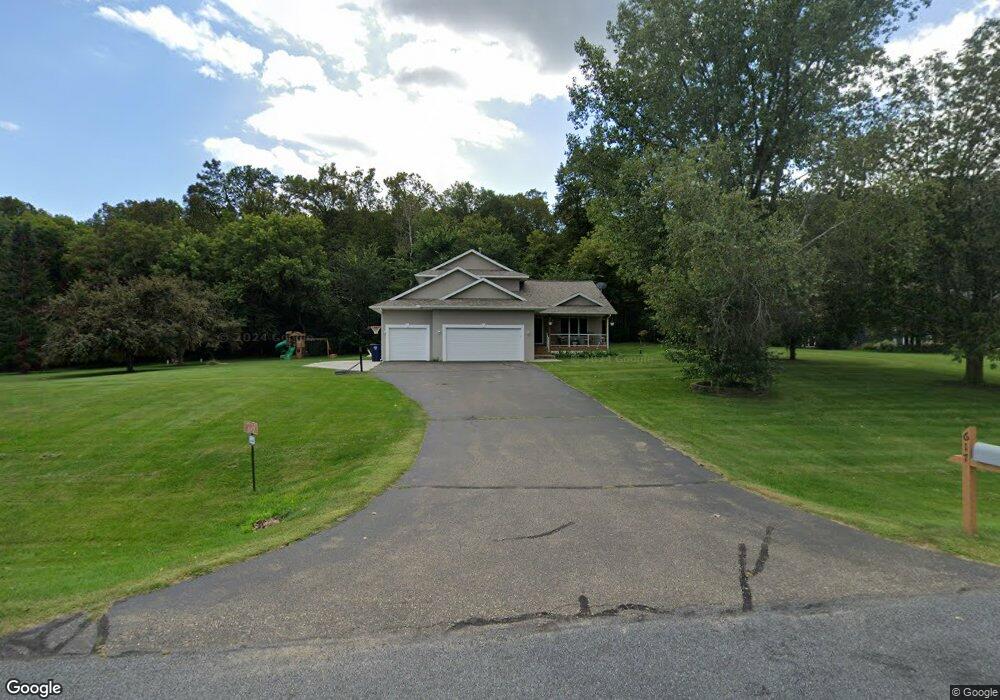
617 Oakley Cir Hudson, WI 54016
Troy NeighborhoodEstimated Value: $598,000 - $652,421
4
Beds
4
Baths
3,752
Sq Ft
$166/Sq Ft
Est. Value
About This Home
This home is located at 617 Oakley Cir, Hudson, WI 54016 and is currently estimated at $622,355, approximately $165 per square foot. 617 Oakley Cir is a home located in St. Croix County with nearby schools including River Crest Elementary School, Hudson Middle School, and Hudson High School.
Ownership History
Date
Name
Owned For
Owner Type
Purchase Details
Closed on
Jul 28, 2020
Sold by
Gabriel Barry K and Gabriel Jodele M
Bought by
Williams Lee and Williams Amber
Current Estimated Value
Home Financials for this Owner
Home Financials are based on the most recent Mortgage that was taken out on this home.
Original Mortgage
$190,000
Outstanding Balance
$166,635
Interest Rate
3%
Mortgage Type
New Conventional
Estimated Equity
$455,720
Purchase Details
Closed on
Dec 23, 2004
Sold by
Nicholaus Antony J and Nicholaus Jennifer J
Bought by
Gabriel Barry K and Gabriel Jodele M
Home Financials for this Owner
Home Financials are based on the most recent Mortgage that was taken out on this home.
Original Mortgage
$260,000
Interest Rate
5.83%
Mortgage Type
New Conventional
Create a Home Valuation Report for This Property
The Home Valuation Report is an in-depth analysis detailing your home's value as well as a comparison with similar homes in the area
Home Values in the Area
Average Home Value in this Area
Purchase History
| Date | Buyer | Sale Price | Title Company |
|---|---|---|---|
| Williams Lee | $415,000 | Results Title | |
| Gabriel Barry K | $332,000 | Burnet Title |
Source: Public Records
Mortgage History
| Date | Status | Borrower | Loan Amount |
|---|---|---|---|
| Open | Williams Lee | $190,000 | |
| Previous Owner | Gabriel Barry K | $260,000 |
Source: Public Records
Tax History
| Year | Tax Paid | Tax Assessment Tax Assessment Total Assessment is a certain percentage of the fair market value that is determined by local assessors to be the total taxable value of land and additions on the property. | Land | Improvement |
|---|---|---|---|---|
| 2025 | $5,835 | $495,300 | $115,100 | $380,200 |
| 2024 | $54 | $495,300 | $115,100 | $380,200 |
| 2023 | $5,559 | $495,300 | $115,100 | $380,200 |
| 2022 | $5,316 | $495,300 | $115,100 | $380,200 |
| 2021 | $5,161 | $338,100 | $80,100 | $258,000 |
| 2020 | $5,243 | $338,100 | $80,100 | $258,000 |
| 2019 | $5,056 | $338,100 | $80,100 | $258,000 |
| 2018 | $4,871 | $338,100 | $80,100 | $258,000 |
| 2017 | $4,638 | $338,100 | $80,100 | $258,000 |
| 2016 | $4,638 | $338,100 | $80,100 | $258,000 |
| 2015 | $4,242 | $338,100 | $80,100 | $258,000 |
| 2014 | $4,100 | $338,100 | $80,100 | $258,000 |
| 2013 | $4,222 | $338,100 | $80,100 | $258,000 |
Source: Public Records
Map
Nearby Homes
- XXX Gilbert Rd
- 570 Coulee Trail
- 602 Summerfield Cir
- 90th Tower Rd
- 640 Gilbert Rd
- 722 (Lot 40) Crest Curve
- 725 (Lot 53) Crest Curve
- 725 Crest Curve
- 745 Mount Curve Ct
- 491 (Lot 10) Prominence Way
- 467 (Lot 2) Prominence Way
- 469 (Lot 1) Prominence Way
- 117 Heirloom Ave
- 43 Canary Way
- 421 N Glover Rd
- 404 Moelter Ln
- 488 (Lot 16) Summit Ridge
- 408 Moelter Ln
- 395 Moelter Ln
- 28 Heritage Blvd
Your Personal Tour Guide
Ask me questions while you tour the home.