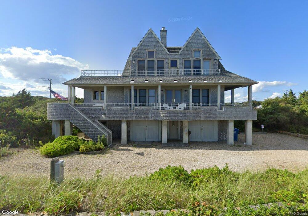
617 Surf Dr Falmouth, MA 02540
Falmouth Village NeighborhoodEstimated Value: $2,209,000 - $3,216,000
4
Beds
2
Baths
2,278
Sq Ft
$1,129/Sq Ft
Est. Value
About This Home
This home is located at 617 Surf Dr, Falmouth, MA 02540 and is currently estimated at $2,571,269, approximately $1,128 per square foot. 617 Surf Dr is a home located in Barnstable County with nearby schools including Mullen-Hall School, Lawrence School, and Morse Pond School.
Ownership History
Date
Name
Owned For
Owner Type
Purchase Details
Closed on
Jul 7, 2017
Sold by
Freeman James L and Freeman Mary A
Bought by
Kenneth W Gordon T W and Kenneth Gordon
Current Estimated Value
Purchase Details
Closed on
Aug 12, 2011
Sold by
Reilly Deborah
Bought by
Freeman James L and Freeman Mary A
Home Financials for this Owner
Home Financials are based on the most recent Mortgage that was taken out on this home.
Original Mortgage
$750,000
Interest Rate
5%
Mortgage Type
Purchase Money Mortgage
Purchase Details
Closed on
May 28, 1999
Sold by
Pacifico Richard D and Pacifico Gail A
Bought by
Reilly Deborah
Create a Home Valuation Report for This Property
The Home Valuation Report is an in-depth analysis detailing your home's value as well as a comparison with similar homes in the area
Home Values in the Area
Average Home Value in this Area
Purchase History
| Date | Buyer | Sale Price | Title Company |
|---|---|---|---|
| Kenneth W Gordon T W | $1,420,000 | -- | |
| Kenneth W Gordon T W | $1,420,000 | -- | |
| Freeman James L | $1,325,000 | -- | |
| Freeman James L | $1,325,000 | -- | |
| Reilly Deborah | $510,000 | -- | |
| Reilly Deborah | $510,000 | -- |
Source: Public Records
Mortgage History
| Date | Status | Borrower | Loan Amount |
|---|---|---|---|
| Previous Owner | Freeman James L | $750,000 | |
| Previous Owner | Reilly Deborah | $300,000 |
Source: Public Records
Tax History Compared to Growth
Tax History
| Year | Tax Paid | Tax Assessment Tax Assessment Total Assessment is a certain percentage of the fair market value that is determined by local assessors to be the total taxable value of land and additions on the property. | Land | Improvement |
|---|---|---|---|---|
| 2025 | $13,813 | $2,353,100 | $1,511,600 | $841,500 |
| 2024 | $13,000 | $2,070,000 | $1,314,400 | $755,600 |
| 2023 | $13,101 | $1,893,200 | $1,314,400 | $578,800 |
| 2022 | $11,754 | $1,460,100 | $940,200 | $519,900 |
| 2021 | $11,671 | $1,373,100 | $899,300 | $473,800 |
| 2020 | $11,093 | $1,291,400 | $817,600 | $473,800 |
| 2019 | $11,018 | $1,287,100 | $817,600 | $469,500 |
| 2018 | $10,970 | $1,275,600 | $817,600 | $458,000 |
| 2017 | $10,640 | $1,247,400 | $817,600 | $429,800 |
| 2016 | $10,441 | $1,247,400 | $817,600 | $429,800 |
Source: Public Records
Map
Nearby Homes
- 87 Oyster Pond Rd
- 38 Landfall Unit 38
- 38 Landfall
- 251 Woods Hole Rd
- 15 Hedge Ln
- 76 F r Lillie Rd
- 29 Wilson Rd
- 44 Carey Ln
- 65 Walker St
- 71 Main St
- 9 Strawberry Hill Rd
- 9 Strawberry Hill Rd
- 98 Main St
- 98 Main St Unit 1
- 54 Whitman Rd
- 82 Harbor Hill Rd
- 30 Katherine Lee Bates Rd
- 533 Woods Hole Rd Unit B101
- 533 Woods Hole Rd Unit D101
- 533 Woods Hole Rd Unit B102