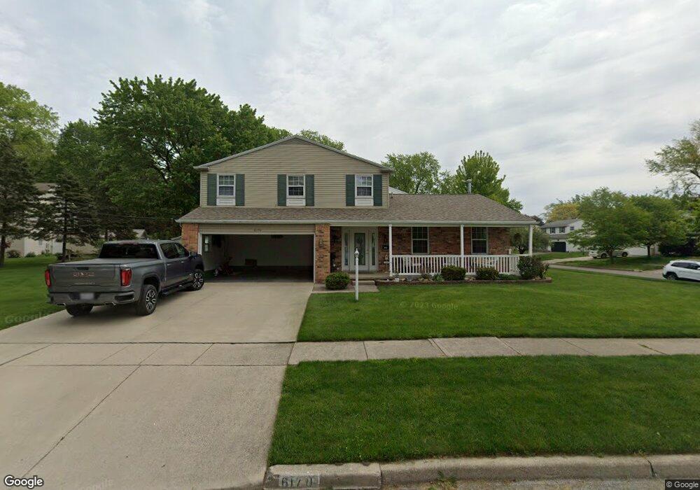
6170 Barnstable Dr Toledo, OH 43613
Whitmer-Trilby NeighborhoodEstimated Value: $244,483 - $254,000
4
Beds
2
Baths
1,820
Sq Ft
$137/Sq Ft
Est. Value
About This Home
This home is located at 6170 Barnstable Dr, Toledo, OH 43613 and is currently estimated at $249,621, approximately $137 per square foot. 6170 Barnstable Dr is a home located in Lucas County with nearby schools including Meadowvale Elementary School, Washington Junior High School, and Jefferson Junior High School.
Ownership History
Date
Name
Owned For
Owner Type
Purchase Details
Closed on
Feb 24, 1997
Sold by
White Richard C
Bought by
Peters Terence A
Current Estimated Value
Home Financials for this Owner
Home Financials are based on the most recent Mortgage that was taken out on this home.
Original Mortgage
$40,000
Interest Rate
7.92%
Mortgage Type
New Conventional
Purchase Details
Closed on
Dec 5, 1990
Sold by
Wagner David E and D J
Create a Home Valuation Report for This Property
The Home Valuation Report is an in-depth analysis detailing your home's value as well as a comparison with similar homes in the area
Home Values in the Area
Average Home Value in this Area
Purchase History
| Date | Buyer | Sale Price | Title Company |
|---|---|---|---|
| Peters Terence A | $130,800 | -- | |
| -- | $101,000 | -- |
Source: Public Records
Mortgage History
| Date | Status | Borrower | Loan Amount |
|---|---|---|---|
| Closed | Peters Terence A | $40,000 |
Source: Public Records
Tax History Compared to Growth
Tax History
| Year | Tax Paid | Tax Assessment Tax Assessment Total Assessment is a certain percentage of the fair market value that is determined by local assessors to be the total taxable value of land and additions on the property. | Land | Improvement |
|---|---|---|---|---|
| 2024 | $2,176 | $69,475 | $10,465 | $59,010 |
| 2023 | $4,311 | $59,010 | $8,820 | $50,190 |
| 2022 | $4,293 | $59,010 | $8,820 | $50,190 |
| 2021 | $4,368 | $59,010 | $8,820 | $50,190 |
| 2020 | $4,233 | $48,965 | $7,315 | $41,650 |
| 2019 | $4,113 | $48,965 | $7,315 | $41,650 |
| 2018 | $3,704 | $48,965 | $7,315 | $41,650 |
| 2017 | $3,642 | $44,275 | $8,505 | $35,770 |
| 2016 | $3,647 | $126,500 | $24,300 | $102,200 |
| 2015 | $3,637 | $126,500 | $24,300 | $102,200 |
| 2014 | $3,017 | $44,280 | $8,510 | $35,770 |
| 2013 | $3,017 | $44,280 | $8,510 | $35,770 |
Source: Public Records
Map
Nearby Homes
- 6149 Everwood Rd
- 6102 Everwood Rd
- 6033 Everwood Rd
- 6032 Atwell Rd
- 2807 W Smith
- 3250 Brock Dr
- 6051 Dellwood Dr
- 6139 Secor Rd
- 3334 Thelma Dr
- 6644 Douglas Rd
- 6220 Whiteford Center Rd
- 2424 Bodette Ave
- 5750 Winona Dr
- 2315 Ann Dr
- 6240 Whiteford Center Rd
- 5530 Douglas Rd
- 5949 Murnen Rd
- 5737 Yermo Dr
- 5501 Ruth Ave
- 3155 Chanson Valley Rd
- 2742 Tarrytowne Dr
- 6171 Barnstable Dr
- 6180 Barnstable Dr
- 2738 Tarrytowne Dr
- 2810 Tarrytowne Dr
- 2755 Tarrytowne Dr
- 2751 Tarrytowne Dr
- 2761 Tarrytowne Dr
- 6179 Barnstable Dr
- 2743 Tarrytowne Dr
- 2803 Tarrytowne Dr
- 2732 Tarrytowne Dr
- 6185 Barnstable Dr
- 2816 Tarrytowne Dr
- 2737 Tarrytowne Dr
- 2811 Tarrytowne Dr
- 2734 Ralphwood Dr
- 2731 Tarrytowne Dr
- 6171 Meadowvale Dr
- 2822 Tarrytowne Dr